Park History
Local Native Americans witnessed the collapse of
Mount Mazama and kept the event alive in their legends. One ancient legend
of the Klamath people closely parallels the geologic story which emerges
from today's scientific research. The legend tells of two Chiefs, Llao of
the Below World and Skell of the Above World, pitted in a battle which
ended up in the destruction of Llao's home, Mt. Mazama. The battle was
witnessed in the eruption of Mt. Mazama and the creation of Crater Lake.
|
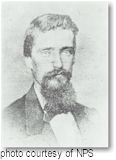
John Wesley Hillman
|
The Klamaths revered the lake and the surrounding
area, keeping it undiscovered by white explorers until 1853. That year, on
June 12, three gold prospectors, John Wesley Hillman, Henry Klippel, and
Isaac Skeeters, came upon a long, sloping mountain. Upon reaching its
highest point, a huge, awe-inspiring lake was visible. "This is the
bluest lake we've ever seen," they reported, and named it Deep Blue
Lake. But gold was more on the minds of settlers at the time and the
discovery was soon forgotten.
 Captain Clarence Dutton was the next man to make a
discovery at Crater Lake. Dutton commanded a U.S. Geological Survey party
which carried the Cleetwood, a half-ton survey boat, up the steep
slopes of the mountain then lowered it to the lake. From the stern of the Cleetwood,
a piece of pipe on the end of a spool of piano wire sounded the depth of
the lake at 168 differnt points. Dutton's soundings of 1,996 feet were
amazingly close to the sonar readings made in 1959 that established the
lake's deepest point at 1,932 feet. Captain Clarence Dutton was the next man to make a
discovery at Crater Lake. Dutton commanded a U.S. Geological Survey party
which carried the Cleetwood, a half-ton survey boat, up the steep
slopes of the mountain then lowered it to the lake. From the stern of the Cleetwood,
a piece of pipe on the end of a spool of piano wire sounded the depth of
the lake at 168 differnt points. Dutton's soundings of 1,996 feet were
amazingly close to the sonar readings made in 1959 that established the
lake's deepest point at 1,932 feet.
William Gladstone Steel devoted his life and fortune
to the establishment and management of Crater Lake National Park. His
preoccupation with the lake began in 1870. In his efforts to bring
recognition to the park, he participated in lake surveys that provided
scientific support. He named many of the lake's landmarks, including
Wizard Island, Llao Rock, and Skell Head. Steel's dream was realized on
May 22, 1902 when President Theodore Roosevelt signed the bill giving
Crater Lake national park status. And because of Steel's involvement,
Crater Lake Lodge was opened in 1915 and the Rim Drive was completed in
1918.
Crater Lake National Park is fast approaching its
100th birthday. The celebration of one of our nation's oldest parks is a
testament to the courage and determination of William G. Steel and the
countless others who have been involved in the preservation of this
national treasure. In looking to the future appreciation and preservation
of this park, knowledge of its history and origins are imperative in
keeping with the tradition of Crater Lake's unique past.
Visitor Centers
Steel Information Center
The Steel Center at park headquarters is open every day from early April
through late October, 9 AM to 5 PM. From November through March, it is
open Friday through Sunday (except for Christmas day) from 10 AM to 4 PM.
Self service information is available Monday through Thursday during the
same hours. (During the winter months, National Park Service information
is also available from 10 AM to 4 PM daily at the Rim Contact Station
located inside the cafeteria building at Rim Village.) A park ranger is on
duty to assist you with information, weather forecasts, backcountry
camping permits, ski route advisories, and safety tips. A 20 minute film The
Crater Lake Story describes the formation of Crater Lake through a
story passed down by Native Americans of this area. It is shown throughout
the day in the auditorium. For more information, the Steel Information
Center may be contacted at (541) 594-2211 extension 402. Books,
maps, posters, postcards, and educational materials are available for
purchase here from the Crater Lake Natural History Association. The Steel
Center has public restrooms and is fully accessible. A post office is also
located in this building.
Rim Village Visitor Center
This visitor center is located on the south rim of the caldera,
approximately 200 yards west of the Crater Lake Lodge. It is open from
early June through late September. General park information, backcountry
camping permits, and educational sales items are available at this
location.
Sinnott Memorial Overlook and
Crater Lake Lodge
Both of these facilities have interpretive displays and exhibits which are
open to the public in the summer.
Day Visits
Mazama Village
 Shortly
after passing through the Annie Spring Entrance Station you will encounter
Mazama Village. Mazama Village is one of two areas in the park where
services are provided. The only major campground in the park is located
here (198-site Mazama Village Campground). Lodging is also available at
the 40-unit Mazama Village Motor Inn. The Mazama Village Store has
convenience store items, a coin-operated laundry and showers, firewood,
and unleaded gasoline. Shortly
after passing through the Annie Spring Entrance Station you will encounter
Mazama Village. Mazama Village is one of two areas in the park where
services are provided. The only major campground in the park is located
here (198-site Mazama Village Campground). Lodging is also available at
the 40-unit Mazama Village Motor Inn. The Mazama Village Store has
convenience store items, a coin-operated laundry and showers, firewood,
and unleaded gasoline.
Munson Valley
The primary visitor service in this section of
the park is the William G. Steel Information Center (open year-round).
Information, backcountry permits, exhibits, maps and publication sales, an
audio-visual program, and first aid can be obtained at the center. The
other developments in Munson Valley are for park support personnel.
If you approach Munson Valley from the
north (accessible only from late June to October), the easterly portion of
the Rim Drive is a left-hand turn just past the Steel Information Center.
Continuing straight ahead (south) takes you to Mazama and the Annie Spring
Entrance Station. If you approach Munson Valley from the south, you
encounter the junction with the Rim Drive. Proceeding north-west, you
begin the clock-wise portion of the Rim Drive, and access to the Rim
Village. Turning east takes you around Crater Lake in a counter-clockwise
direction and is the quickest route to The Pinnacles section of the park.
A short distance (east) of this road
junction on the Rim Drive is the delightful Castle Crest Wildflower Trail.
While this is a short .4-mile loop trail, the tread is uneven and is not
suitable for wheelchairs. When flowers are in bloom the profusion of
colors is spectacular. The trail passes from forest, to wet meadows,
crosses a tributary of Munson Creek, and finally passes a small dry slope
exposing the visitor to a wide assortment of Northwest wildflowers.
Rim Village
 The hub of
development at Crater Lake National Park is concentrated in Rim Village.
The historic Crater Lake Lodge (extensively remodeled in 1995 after a
6-year closure), Sinnott Memorial Overlook, Rim Village Visitor Center,
and Gift Shop/Cafeteria are all located at Rim Village. The hub of
development at Crater Lake National Park is concentrated in Rim Village.
The historic Crater Lake Lodge (extensively remodeled in 1995 after a
6-year closure), Sinnott Memorial Overlook, Rim Village Visitor Center,
and Gift Shop/Cafeteria are all located at Rim Village.
The views of Crater Lake from the Rim are
certainly the highlight of Rim Village. A path follows along the Rim from
Discovery Point to Crater Lake Lodge (2.6 miles round-trip). An extension
of this trail proceeds from Crater Lake Lodge to the top of Garfield Peak
(3.4 miles round-trip). Walking a portion of any of these trails affords
the visitor views of Wizard Island, The Watchman, Hillman Peak, Mt.
Thielsen (located outside of the park to the north), Cleetwood Cove
(located at the base of the North Rim, nearly 6 miles distance), Mt.
Scott, and Garfield Peak. A short walk to Sinnott Memorial, with a small
museum and ranger-talks during the summer, gives a spectacular view 900
feet down to the lake's surface.
Winter lasts for eight months at Crater
Lake National Park. At an elevation of 7,100 feet, snow lingers long into
the "summer". While access to the Rim Village is open
year-round, most of the facilities are buried under the 533 inches of snow
Crater Lake receives each year (on average). The Rim Village Gift
Store/Cafeteria are the only services open in winter. Ranger-led snowshoe
walks are offered on weekends and holidays.
Rim Drive
 The
33-mile Rim Drive encircles Crater Lake, with each mile giving a very
different perspective of the lake, rim, and surrounding terrain. Open
only during the summer from late June to mid-October, there are
numerous overlooks, many with interpretive signs. The only access to the
lake itself is via a steep trail to Cleetwood Cove, where boat
tours of the lake are offered. Numerous picnic areas can be found
along the Rim Drive, as well as hiking access to Garfield Peak (from Rim
Village), Lightning Springs (west side), Cleetwood Cove (north side),
Mount Scott (east side), Sun Notch Viewpoint and Crater Peak (south side).
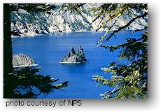
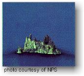
Both Kerr Notch and Sun Notch Viewpoints are particularly spectacular
viewpoints, with views down to Phantom Rock and across the lake to Wizard
Island. To protect the fragile meadows, please stay on the established
trails! The
33-mile Rim Drive encircles Crater Lake, with each mile giving a very
different perspective of the lake, rim, and surrounding terrain. Open
only during the summer from late June to mid-October, there are
numerous overlooks, many with interpretive signs. The only access to the
lake itself is via a steep trail to Cleetwood Cove, where boat
tours of the lake are offered. Numerous picnic areas can be found
along the Rim Drive, as well as hiking access to Garfield Peak (from Rim
Village), Lightning Springs (west side), Cleetwood Cove (north side),
Mount Scott (east side), Sun Notch Viewpoint and Crater Peak (south side).
Both Kerr Notch and Sun Notch Viewpoints are particularly spectacular
viewpoints, with views down to Phantom Rock and across the lake to Wizard
Island. To protect the fragile meadows, please stay on the established
trails!
The Pinnacles
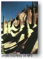 The
Pinnacles can be reached in the summer from the Rim Drive on a paved,
6-mile road. These eerie spires of eroded ash, rise from the edges of Sand
and Wheeler Creeks in pinnacle-fashion. Once upon a time, the road
continued east of the turn-out, to the former East Entrance of the park. A
path now replaces the old road and follows the rim of Sand Creek (and more
views of pinnacles) to where the entrance arch still stands. Along
the drive to The Pinnacles is the 16-site, tents only, Lost Creek
Campground. An alternate route back to the Rim Drive, is to take the
Grayback Road (one-way, westbound only). The
Pinnacles can be reached in the summer from the Rim Drive on a paved,
6-mile road. These eerie spires of eroded ash, rise from the edges of Sand
and Wheeler Creeks in pinnacle-fashion. Once upon a time, the road
continued east of the turn-out, to the former East Entrance of the park. A
path now replaces the old road and follows the rim of Sand Creek (and more
views of pinnacles) to where the entrance arch still stands. Along
the drive to The Pinnacles is the 16-site, tents only, Lost Creek
Campground. An alternate route back to the Rim Drive, is to take the
Grayback Road (one-way, westbound only).
Camping
There are two campgrounds inside the
park:
Mazama Campground, operated by the
park's concessionaire, contains 200 sites and is open from June through
early October. Reservations are not taken, but generally there are
plenty of sites available. The campground offers running water, fire
rings, picnic tables, and flush toilets. Wheelchair sites are available.
The fee for 1999 was $14.75 per tent/camper site or $15.75 per RV site.
More than 2 adults per site - $3 per additional person. Lost
Creek Campground contains 16 sites for tent camping only. It is located in
the southeast corner of the park on the spur road to the Pinnacles
overlook. It is open from July through early October. Fees are $10 per
site.
Please Note - Weather can impact the opening and closing dates of both
campgrounds.
Camping within 40 miles of Crater Lake
is available at the following sites:
Oregon
State Parks (Campsite Information Center): (800)
452-5687
Winema
National Forest
Headquarters office in Klamath Falls - (541) 883-6714
Chiloquin Ranger Station - (541) 783-2221
Rogue
River National Forest
Headquarters office in Medford - (541) 776-3600
Prospect Ranger Station - (541) 560-3623
Umqua
National Forest
Headquarters office in Roseburg - (541) 672-6601
Diamond Lake Ranger Station - (541) 498-2531
Trails
General Information
 There
are more than 90 miles of trails leading into the backcountry of Crater
Lake National Park. These are usually snow-free from mid-July to
early-October. Just over 90% of the park is managed as wilderness, though
these areas have yet to be designated as such. A permit is required for
all overnight trips. There
are more than 90 miles of trails leading into the backcountry of Crater
Lake National Park. These are usually snow-free from mid-July to
early-October. Just over 90% of the park is managed as wilderness, though
these areas have yet to be designated as such. A permit is required for
all overnight trips.
Be prepared for sudden and extreme weather
changes. Be prepared for the unexpected and carry extra food and water.
Always carry raingear. Pack-out or bury human waste more than 200 feet
from water. Stay on trails. Dogs and other pets, bicycles, and motor
vehicles are NOT allowed on any park trails. Remember, elevations range
from 6,000-9,000 feet- take it easy and have fun!
Selected Hiking Trails
| Trail Name |
Distance |
Difficulty |
Trail Highlights |
| Sun Notch Viewpoint |
.5 mile roundtrip |
Short stroll, allow 30 minutes |
Overlook of Crater Lake and Phantom Ship |
| Castle Crest Wildflower Garden |
.5 mile loop trail |
Short stroll, allow 30 minutes |
Display of wildflowers in August |
| Godfrey Glen |
1 mile loop trail |
Gentle level hike, allow 45 minutes |
Overlook of Annie Creek Canyon |
| Watchman Peak |
1.4 miles roundtrip |
Moderate climb, 500ft. rise, allow 1 hour |
Historic fire tower, overlook of Wizard
Island |
| Annie Creek Canyon |
1.7 mile loop |
Moderate climb, allow 1.5 hours |
Deep stream cut canyon |
| Garfield Peak |
3.4 miles roundtrip |
Strenuous climb, 1,000ft. rise, allow 2 to 3
hours |
Panoramic views, |
| Mt. Scott |
5 miles roundtrip |
Strenuous climb, 1,500ft. rise, allow 3 hours |
Highes peak in park, historic fire tower |
Cleetwood Cove Trail
Visitors wishing to reach the lakeshore of Crater Lake will need to hike
the Cleetwood Cove trail. Located on the north side of Crater Lake, it is
the only safe and legal access to the lake. The trail is one mile
in length (one-way) and drops 700 feet as you descend from the East Rim
Drive trailhead to the lakeshore. On your return trip, this is comparable
to climbing 65 flights of stairs! The Cleetwood Cove hiking trail is
recommended only for those in good physical condition and should not be
attempted by visitors with heart, breathing, or leg problems. It is not
accessible for visitors with mobility impairments. Hikers are advised to
wear closed-toe shoes and bring plenty of water, sunscreen, and mosquito
repellent. Toilets are available at both the trailhead and the boat dock
area, however are not available on Wizard Island. Due to the park's heavy
snow conditions, the trail typically does not open until late June and
closes in mid-October.
Winter Activities
 Crater
Lake National Park receives an average of 45 feet of snow annually. The only
road open during the winter months is the southern entrance road up to
Rim Village. During periods of heavy snowfall, the road to Rim Village may
also be closed. The Steel Information Center is open daily except for
Christmas, as is Rim Village where a cafeteria and gift shop are located.
Ranger-led winter ecology walks are held every weekend. Other
popular winter activities include snowmobiling, snow shoeing and
cross-country skiing,. Crater
Lake National Park receives an average of 45 feet of snow annually. The only
road open during the winter months is the southern entrance road up to
Rim Village. During periods of heavy snowfall, the road to Rim Village may
also be closed. The Steel Information Center is open daily except for
Christmas, as is Rim Village where a cafeteria and gift shop are located.
Ranger-led winter ecology walks are held every weekend. Other
popular winter activities include snowmobiling, snow shoeing and
cross-country skiing,.
The following is a list of selected ski
trails at the park:
- Discovery Point and Wizard Island Overlook This
is the most popular, and easiest ski trail in the park. It provides
spectacular views of the lake. Flat and rolling terrain. Round-trip: 2
miles to Discovery Point; 5 miles to Wizard Island Overlook.
- Mazama Village Loop This loop provides easy, flat
skiing conditions for beginners. Located next to the entrance station
near the Junction of Hwy 62 and the road to Crater Lake. Round-trip: 1
mile.
- Hemlock LoopA rolling journey through ancient
forest. Views of the Klamath Basin to the southeast. Moderate
difficulty. Round-trip: 1 mile.
- Sun Notch Trail A good alternative to skiing the
rim, especially when the weather is poor. Once at Sun Notch, you can
look down the 1,000 foot drop to the lake's surface and Phantom Ship.
Extreme caution must be exercised near the rim, snow cornices may be
present! During high avalanche conditions, use the marked avalanche
bypass route. Moderate difficulty. Round-trip: 10 miles.
- Raven Trail Steep descent through snow-covered
hemlocks, including several sharp curves. Immediately upon leaving the
woods, the trail crosses a potentially dangerous avalanche chute;
caution is advised. Round-trip: 2 miles.
- Dutton Creek Zig-zagging through the forest, this
trail descends steeply in the first mile among dense hemlocks. It
eventually meets the Pacific Crest Trail. A steep climb over a ridge
brings you back out to the roadway, either at Hwy. 62 or at Annie
Springs. One way: 9 miles.
- Skiing around Crater Lake A complete trip around
the lake takes 2-3 days, longer during storms. There are no shelters
along the 33 mile route. This trip should only be attempted by
experienced and properly equipped skiers.
|


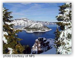 Crater Lake is widely known for its intense blue
color and spectacular views. During summer, visitors may navigate the
Rim Drive around the lake, enjoy boat tours on the lake surface, stay in
the historic Crater Lake Lodge, camp at Mazama Village, or hike some of
the park's various trails including Mt. Scott at 8,929 ft. Diverse
interpretive programs enhance visitors' knowledge and appreciation of
this national park, 90% of which is managed as wilderness. The winter
brings some of the heaviest snowfall in the country, averaging 533
inches per year. Although park facilities mostly close for this snowy
season, visitors may view the lake during fair weather, enjoy
cross-country skiing, and participate in weekend snowshoe hikes.
Crater Lake is widely known for its intense blue
color and spectacular views. During summer, visitors may navigate the
Rim Drive around the lake, enjoy boat tours on the lake surface, stay in
the historic Crater Lake Lodge, camp at Mazama Village, or hike some of
the park's various trails including Mt. Scott at 8,929 ft. Diverse
interpretive programs enhance visitors' knowledge and appreciation of
this national park, 90% of which is managed as wilderness. The winter
brings some of the heaviest snowfall in the country, averaging 533
inches per year. Although park facilities mostly close for this snowy
season, visitors may view the lake during fair weather, enjoy
cross-country skiing, and participate in weekend snowshoe hikes.