

|
|
|
Thunder Creek Trail
Summary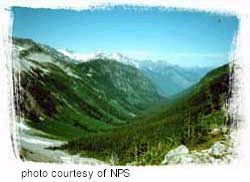 This is an
ideal trail for a short walk, a long day hike, or an extended backpack.
Along the Thunder Creek Valley are ancient forests, streamside openings,
and, from higher points, magnificent views. A recommended walk is to the
junction with Fourth of July Pass Trail at 1.7 miles (2.7 km). Following
Fourth of July Pass Trail up 3.2 miles (5.1 km) of switchbacks to Fourth
of July Pass, or continuing along Thunder Creek for about the same
distance provides beautiful mountain views. Thunder Creek Trail divides
again 9.7 miles from the trailhead to go up Fisher Creek and Easy Pass
(11.3 miles/18.2 km further) to exceptionally fine meadows and vistas, or
climbs to Thunder Basin and over Park Creek Pass (9.3 miles further) and
on to the Stehekin Valley. Descriptions for Diablo and Colonial Creek area
day hikes and Easy Pass are on separate handouts. This is an
ideal trail for a short walk, a long day hike, or an extended backpack.
Along the Thunder Creek Valley are ancient forests, streamside openings,
and, from higher points, magnificent views. A recommended walk is to the
junction with Fourth of July Pass Trail at 1.7 miles (2.7 km). Following
Fourth of July Pass Trail up 3.2 miles (5.1 km) of switchbacks to Fourth
of July Pass, or continuing along Thunder Creek for about the same
distance provides beautiful mountain views. Thunder Creek Trail divides
again 9.7 miles from the trailhead to go up Fisher Creek and Easy Pass
(11.3 miles/18.2 km further) to exceptionally fine meadows and vistas, or
climbs to Thunder Basin and over Park Creek Pass (9.3 miles further) and
on to the Stehekin Valley. Descriptions for Diablo and Colonial Creek area
day hikes and Easy Pass are on separate handouts.
Access The first half mile (.8 km) follows Thunder Arm of Diablo Lake. Note the colors of the lake and stream. This is because Thunder Creek carries a heavy load of "rock flour," ground by the many glaciers of its headwaters. This trail was opened by prospectors and trappers. Mining developers and the USFS made major improvements in the early 1900s. Look for old blazes, telephone insulators, and a few cut stumps along the way. At 300 yards (90 m) from the trailhead, a spur leads to Thunder Woods Nature Trail, a self-guided intrepretive walk along a 0.9 mile (1.4 km) loop. At .8 miles (1.3 km), a modern suspension bridge crosses at the historic bridge site. Forest Fires Along Thunder Creek Trail, the first open view is from a 1970 burn at about 4.5 miles. Here an emerging forest of young Douglas-fir and a profusion of seed bearing herbs and shrubs attracts birds, rodents and their predators. Across the valley, note a newer burn from lightning strikes in 1990. Rock cliffs and McAllister Glacier provide natural fire breaks and a splendid backdrop for this evolving forest scene. Campsites A relentless 2.2 mile (3.5 km) climb from the valley bottom at Tricouni Camp leads to Junction Camp and a major trail junction. From this high ridge, enjoy an expansive view of Boston Glacier and Tricouni Peak. From here, one may either take Fisher Creek Trail to Easy Pass, or continue on Thunder Creek Trail to Park Creek Pass. Both ways lead to grand trail experiences. Mining History Above Skagit Queen, the trail rises steeply for a mile (1.6 km) into the mouth of Thunder Basin, a hanging glacial valley. More hiking through avalanche paths and stands of silver fir leads to the fringes of the subalpine zone where Thunder Basin Camp is located, 2.9 miles (4.7 km) beyond Skagit Queen. Park Creek Pass From Park Creek Pass, the trail descends quickly through heather and wildflower meadows into a hanging valley and Buckner Camp. Contouring down the forested slopes of Park Creek Valley, the trail intersects the Stehekin Valley Road 7.9 miles (12.7 km) from the pass at 2,300' (700 m) elevation. Check schedules and make a reservation in advance to take the Park Service shuttle bus to Stehekin Landing. Permits/Information
|
|
For Additional Information Contact: North
Cascades National Park
For more information visit the National Park Service website
|