

|
|
|
Thornton Lakes Trail
Summary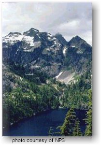 This strenuous
day hike or overnight backpack leads to a series of 3 alpine lakes. It
is 5.3 miles (one way; 8.5 km) to the first lake. A scramble route
to Trapper Peak offers magnificent views. This strenuous
day hike or overnight backpack leads to a series of 3 alpine lakes. It
is 5.3 miles (one way; 8.5 km) to the first lake. A scramble route
to Trapper Peak offers magnificent views.
Access The first 2.3 trail miles (3.7 km) follow an old road grade through a logging area from the 1960s. A natural mix of Douglas-fir, Pacific silver fir, hemlock, cedar, alder, and maples are returning. This lower section can be brushy. Upper Trail A steep .6 mile (1 km) drop from the saddle ends at Lower Thornton Lake. Use caution when crossing the outlet! These classic cirque lakes were created as glaciers gouged out rock basins, then retreated. Three designated campsites are located near the lake outlet. A primitive path to the upper lakes proceeds from that point. Wildlife A permit (no charge) is required for all overnight stays in the backcountry. Camping near Lower Thornton Lake must be at designated sites. Cross-country camping is allowed only at the third lake, Triumph Col, or the ridge to the west of the lakes. Permits/Information
|
|
For Additional Information Contact: North
Cascades National Park
For more information visit the National Park Service website
|