
|
|
|
Chilliwach River-Copper Ridge Trail
Summary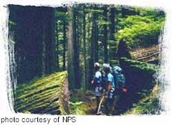 The
Chilliwack River and Copper Ridge trail system provide trail access to the
remote northwestern park area. It is noted for its scenic subalpine
meadows on Copper Ridge, and for the 18.5 mile (30 km) route that follows
the Chilliwack River from its source near Hannegan Pass to Chilliwack Lake
in Canada. The
Chilliwack River and Copper Ridge trail system provide trail access to the
remote northwestern park area. It is noted for its scenic subalpine
meadows on Copper Ridge, and for the 18.5 mile (30 km) route that follows
the Chilliwack River from its source near Hannegan Pass to Chilliwack Lake
in Canada.
Access From Hannegan Trailhead (elevation 3100', or 940 m) the trail climbs through silver fir stands and avalanche clearings to Hannegan Pass at 4500' (1370 m). Views of Ruth Mountain dominate this area. From the pass, the trail descends to the headwaters of the Chilliwack River and Boundary Camp, located just inside the national park boundary. Boundary Camp is in a subalpine area and fires are not permitted. Here the trail splits, with one fork heading up to Copper Ridge and the other continuing down the Chilliwack Valley. Copper Ridge Campfires are not allowed anywhere on the ridge because of the extremely delicate nature of the plants and soils. You may notice a coarse netting material covering several areas around Egg and Copper Lakes. This material has been placed in areas severely damaged by overuse in the past, and is helping natural plant cover to return to these areas. It is very important that you do not walk on or otherwise disturb the covered areas. Chilliwack Valley The trail up Brush Creek to Whatcom Pass is located 7 miles (11 km) from Boundary Camp, and is just east of the Chilliwack River crossing. Graybeal Camp is located 2 miles (3 km) up the valley, and Whatcom Camp is just before the pass, 5 miles (8 km) from the trail junction. From here hikers can continue over the pass to Ross Lake via the Little Beaver or Big Beaver drainages. There are a number of campsites along both routes. A composting toilet is available during summer at Whatcom Camp. Permits/Information
|
|
For Additional Information Contact: North
Cascades National Park
For more information visit the National Park Service website
|