

|
|
|
History | Places | Activities

|
Description Natural Bridges protects some of the finest examples of ancient stone architecture in the southwest. The monument is located in southeast Utah on a pinyon-juniper covered mesa bisected by deep canyons of Permian age Cedar Mesa Sandstone. Where meandering streams cut through the canyon walls, three natural bridges formed: Kachina, Owahcomo and Sipapu. At an elevation of 6,500 feet above sea level, the Monument is home to a wide variety of plants and animals. Plants range from the fragile cryptobiotic soil crusts to remnant stands of Douglas-fir and ponderosa pine. Natural Bridges was established in 1908, making it the oldest National Park Service site in Utah.
|
Monument Information Hours/Seasons: Natural Bridges is open year-round. The scenic drive is open every day from early morning until about 30 minutes past sunset. Directions: The entrance to Natural Bridges is at the end of Highway 275, which is roughly 35 miles west of Blanding on Highway 95. Fees: Weather: Summer highs may exceed 100 Degrees Fahrenheit, with lows in the 60's. Fall and Spring temperatures are milder, with highs in the 70's and 80's. Winter temperatures range from highs in the 40's and 50's to lows well below freezing.
|
|||
|
Human Prehistory European History Naming the Bridges
Horsecollar Ruin History I am very much thrilled over a discovery I made the other day. I was working about half way between Sipapu and Kachina Bridges and at lunch time I was in the narrow canyon where the sun does not shine very much at that time of year, but I could see that about thirty feet above me the sun was shining warm and bright on the cliff. I crawled up a broken ledge thinking that it would be nice to eat my lunch there when to my surprise I saw a ledge full of houses, within 80 yards of the trail over which I have walked for more than twenty years. There is one large kiva with the roof almost complete and a fine ladder standing in the hatchway with the small willows still holding the rungs in place. I could not tell how many rungs are on the ladder because of the debris which the pack rats have piled up around its base; only three and a half feet show between the top of the pile and the hatch. Beside the kiva are two well-preserved stone and adobe houses with no roofs but walls which are in a fine state of preservation. A small barrel shaped structure abuts against one of the houses. Six or eight rooms with walls of fine masonry but partly torn down are also on the ledge. There is a lot of broken pottery and flaked stone lying about. I picked up six arrow points and several broken ones. You know, I felt like a foolish kid to have passed so near these ruins for so many years and not know of their presence, but someone had found them before I did many years ago; a few pits have been dug in the ruins but the kiva has not been touched.Thus, Horsecollar ruins reentered the world of Natural Bridges. Not much has changed since Zeke Johnson's day. The ladder into the kiva is gone, and much of the debris inside has been removed. Sadly, one can no longer find pottery or arrowheads here anymore--practically everything has been taken away by other visitors. But much still remains here to delight the eye and mind. The kiva, for example, is incredibly well preserved, and a rare find. The roof remains original and unaltered by the Park Service. You can see how it was built--large roof beams, overlain by smaller branches, then by reeds and thin sticks, and finally covered by a generous layer of mud-plaster. The ladder, which once protruded from a hole in the roof, has been removed for safekeeping. More than 700 years old like the ruins themselves, it cannot stand to have people climbing on it. Amazingly, some visitors still try to climb inside, often destroying part of the remaining roof. However you don't need to climb in to see what's there. If you look in carefully from the side, you can still see the original fire pit near the center of the floor. In front of it is an upright slab of rock--a deflector stone designed to keep air currents coming from the ventilator shaft in the front wall from blowing out the fire. Toward the rear wall is a small hole called a "Sipapu," perhaps representing the gateway from which the Hopi believe one's spirit enters and leaves this world. There is also a "bench" against the back wall. Was it used as a chair? Storage? While we may never know such specifics, these things left by past peoples fuel our imaginations and add to our perspective. The round "Horsecollar" ruins at the far right end of the alcove are also much as Zeke Johnson first saw them. If you look closely, you can see which one was built first (Hint: one half is completely round, while the other is "stuck on" to the round one). No one knows the exact purpose of these unusual rooms. Why are they so perfectly round, and why did their builders not use the back of the alcove as a wall and save themselves much work? Were they ever roofed? If not, why bother constructing plaster floors? Were they used for storage? If so, why were fires lit inside them? If you come up with a good answer to this puzzle, feel free to jot it down in the register book or tell a Ranger. The remaining structures here--including living space, storage chambers, and at least one other kiva, are in various states of decay, but are still relatively well preserved. You may notice near this kiva a partially burnt piece of wood which has been neatly sawed in half. Archaeologists have taken a sample of the log to use for dating these ruins. Wetter and drier years have produced a pattern of thick and thin growth rings in the wood, which can be perfectly matched to a known pattern of these rings found in wood across the Southwest. This method, known as dendrochronology, allows scientists to tell precisely the age of a piece of wood, and often even the season in which the tree was cut. Because Natural Bridges has been part of the Park Service for so long, its ruins have been well studied and now provide the longest running complete record of tree-ring dates in the Utah, and one of the best in the Southwest. The record is often used by archaeologists elsewhere to date wood. One hundred meters to the north, along this same cliff level, is the north section of Horsecollar Ruins. They consist of several large, finely mortared rooms, with one additional area in front made of stones laid without mortar, and crudely built compared to the others. Why was this oddball room built? Perhaps the builders did not have the luxury of time to make a finely mortared structure. Perhaps fine construction was not necessary, the room being simply a storage room, or for summer use, or maybe a "playpen" to allow small children to be outdoors but away from the cliff edge. Interestingly, one of the doorways here was remodeled to make a smaller opening. Perhaps this was done to conserve heat in the winter, or to impede entry in case of attack. Horsecollar is among the largest and best preserved ancestral Puebloan structures in the Monument. It stands as a reminder that people have lived here for hundreds of years and that we are but the latest visitors in this fragile and beautiful place.
History Before Douglas, local cowboy Jim Scorup named the bridge "Caroline" in honor of his mother. Before that, Cass Hite had named it "Senator.
Owachomo Bridge History Early in the Monument's development, a dirt road led to Owachomo bridge from the south. It ended at the campground and ranger station directly southwest of the bridge. There were no other roads, and visitors seeking the other two bridges hiked or rode horses through the rugged canyons, often guided by the first "custodian" of the National Monument, Ezekial "Zeke" Johnson. Today, remnants of "Zeke's trail", now on the National Register of Historic Places, can still be seen just across the canyon below Owachomo.
Sipapu Bridge History President Augusta Sipapu
Accessibility The visitor center and rest rooms are accessible to all persons. The campground has no designated site for disabled persons but has several sites and one rest room accessible. The three bridge overlook trails are accessible via a concrete sidewalk, however the sidewalk to the Kachina Bridge viewpoint may not be accessible with a standard wheelchair due to its slope.
Camping The Monument's 13-site campground is open year-round, but it is not cleared of snow in the winter. The fee is $10 per night. No reservations are accepted and there is no group site available. Wood fires are permitted, but no wood gathering is allowed inside the Monument. Vehicles over 26 feet long are not allowed in the campground. All sites fill by early afternoon from early March through late October. Rangers at the visitor center can give directions to nearby alternate camping areas.
Hiking There are several short
trails leading to natural bridges and other features.These include: Loop Hike Starting at any of the three bridges, an unmaintained trail system takes you to all three bridges and back across the mesa top to your starting point. The entire loop is about 8.2 miles long and requires about 5 - 6 hours minimum. Hiking between two of the three bridges reduces the mileage to about 5.5 and the time needed to about 3 - 4 hours. Any of the loop hikes should be considered strenuous, since they require ascents and descents of up to 500 vertical feet and Monument elevations range from 6,000 to 6,500 feet above sea level. Hiking the trails during winter can be hazardous due to accumulations of ice and snow, especially the sections entering/exiting the canyon at Sipapu and Kachina Bridges.
Ranger-led Activities Ranger programs are presented in the campground amphitheater spring through fall. Topics and times vary; see schedules posted on area bulletin boards. Guided walks and visitor center patio talks may also be offered. Programs are not presented during the winter months. A Junior Ranger Program is available, with an eight page Kids newspaper full of stories, puzzles, games, and activities. Badges are awarded to children who finish the required number of activities for their age group. Scenic Drive The nine mile long Bridge View Drive is a one-way scenic loop starting and ending near the visitor center. Overlooks for each of the three bridges and one cliff dwelling are reached by short walks from parking areas along the drive. A trailhead for each bridge is also located along the drive, as is a small picnic area. The road is plowed in the winter. The scenic drive is open every day from early morning until about 30 minutes past sunset. Visitor Center The Visitor center has exhibits,
an audiovisual program, books, maps and videos for sale. Rangers are
on duty to answer questions and collect entry fees. Informal interpretive
programs may be given on the patio during peak season. Rest rooms and
water are available 24 hours a day. The hours are:
|
||||
|
For Additional Information Contact:
Natural Bridges National
Monument
|
||||
|
For more information visit the National Park Service website |
||||
 Repeatedly
occupied and abandoned during prehistoric times, Natural Bridges was
first used during the Archaic period, from 7000 B.C. to A.D. 500. Only
the rock art and stone tools left by hunter-gatherer groups reveal that
humans lived here then. Around AD 700, ancestors of modern Puebloan
people moved onto the mesa tops to dry farm and later left as the natural
environment changed. Around AD 1100, new migrants from across the San
Juan River moved into small, single-family houses near the deepest,
best-watered soils throughout this area. In the 1200's, farmers from
Mesa Verde migrated here, but by the 1300's the ancestral Puebloans
migrated south. Navajos and Paiutes lived in the area during later times,
and Navajo oral tradition holds that their ancestors lived among the
early Puebloans.
Repeatedly
occupied and abandoned during prehistoric times, Natural Bridges was
first used during the Archaic period, from 7000 B.C. to A.D. 500. Only
the rock art and stone tools left by hunter-gatherer groups reveal that
humans lived here then. Around AD 700, ancestors of modern Puebloan
people moved onto the mesa tops to dry farm and later left as the natural
environment changed. Around AD 1100, new migrants from across the San
Juan River moved into small, single-family houses near the deepest,
best-watered soils throughout this area. In the 1200's, farmers from
Mesa Verde migrated here, but by the 1300's the ancestral Puebloans
migrated south. Navajos and Paiutes lived in the area during later times,
and Navajo oral tradition holds that their ancestors lived among the
early Puebloans.
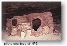 The
Horsecollar Ruin site is a major attraction at Natural Bridges, and
one of the most interesting ancestral Puebloan sites in the area. The
name Horsecollar comes from the shape of the doorways to several
structures here, which were thought to resemble horsecollars. Abandoned
more than 700 years ago, its remarkable state of preservation--for example,
an undisturbed kiva with an original roof and interior design--is due
to the isolation of Natural Bridges and the relatively few visitors
who make the journey down these canyons.
The
Horsecollar Ruin site is a major attraction at Natural Bridges, and
one of the most interesting ancestral Puebloan sites in the area. The
name Horsecollar comes from the shape of the doorways to several
structures here, which were thought to resemble horsecollars. Abandoned
more than 700 years ago, its remarkable state of preservation--for example,
an undisturbed kiva with an original roof and interior design--is due
to the isolation of Natural Bridges and the relatively few visitors
who make the journey down these canyons.  Kachina
is "the middle bridge". Spanning the canyon equidistant from
both
Kachina
is "the middle bridge". Spanning the canyon equidistant from
both 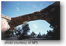 Owachomo
is the smallest and thinnest of the three natural bridges here and is
commonly thought to be the oldest. We may never know for certain, as
each of the bridges certainly have eroded at different rates. Regardless
of its relative age, it is certainly the most fragile and elegant of
the three spans, and an awe inspiring feature of erosion.
Owachomo
is the smallest and thinnest of the three natural bridges here and is
commonly thought to be the oldest. We may never know for certain, as
each of the bridges certainly have eroded at different rates. Regardless
of its relative age, it is certainly the most fragile and elegant of
the three spans, and an awe inspiring feature of erosion.
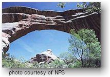 Sipapu
is the largest and most spectacular of the three bridges in the Monument.
It is considered middle aged, older than Kachina but younger than Owachomo.
Its rounded opening and smooth sides are mute evidence of countless
floods bearing scouring rocks and sand. This bridge, whose opening would
almost house the dome of the United States Capitol, has taken thousands
of years to form but will someday collapse and erode as part of the
endless cycles of time and change.
Sipapu
is the largest and most spectacular of the three bridges in the Monument.
It is considered middle aged, older than Kachina but younger than Owachomo.
Its rounded opening and smooth sides are mute evidence of countless
floods bearing scouring rocks and sand. This bridge, whose opening would
almost house the dome of the United States Capitol, has taken thousands
of years to form but will someday collapse and erode as part of the
endless cycles of time and change.