

|
|
|
History | Places | Activities
|
|
|
|
Description Hovenweep protects a collection of unique prehistoric archeological sites. The inhabitants of Hovenweep were part of the large farming culture which occupied the Four Corners region of Utah, Colorado, New Mexico, and Arizona from about 500 B.C. until nearly A.D. 1300. Located along the border between Utah and Colorado, the monument is noted for its solitude and undeveloped, natural character.
|
Monument Information Hours/Seasons: Hovenweep is open year-round. The Ranger Station is open daily from 8:30 a.m.- 4:30 p.m., with extended hours during summer. The Ranger Station is closed winter holidays. Fees: Directions: The only paved entrance road is Highway 262, which travels east from Highway 191 approximately 15 miles south of Blanding. Weather: Summer highs may exceed 100 Degrees Fahrenheit, with lows in the 60's. Fall and Spring temperatures are milder, with highs in the 70's and 80's. Winter temperatures range from highs in the 40's and 50's to lows well below freezing.
|
|||
|
Human Prehistory Ancestral Puebloans The buildings that visitors to Hovenweep see today are the remnants of the settlements these people built during the high point of their occupation of region. The structures here are numerous and varied. Some are square, some D-shaped, some round, some measuring nearly four stories tall. There are towers, kivas, pueblos, room blocks, granaries, check dams, and farming terraces. The ancestral Puebloan's masonry is as beautiful as it is complex, and many of the structures are precariously built atop rock outcroppings, still standing after almost 700 years. Many theories have been offered as to the use of the buildings at Hovenweep. The famous towers could have been used as celestial observatories, defensive structures, storage facilities, civil buildings, homes, or any combination of these. Archeologists have found that most of the towers were associated with kivas (religious and social structures), giving some evidence toward a ceremonial use. Around the towers are piles of rubble that indicate that there were many more structures in existence than are seen today, leaving archeologists to ponder over the actual function of these towers. While we do not know the uses of some buildings, we do know that the people who built them were successful farmers. They terraced their land into farmable plots, formed catch basins to hold water run-off, and built check dams to retain the soil that would normally wash off the cliff edges by erosion. Storage caches along the canyon rims still exist and can be spotted by the discerning eye. These caches would have held dried crops of corn, beans and squash for later use. Some believe that stored crops would be plentiful enough to last through anticipated dry years as well. Masonry Styles
Departure
European History
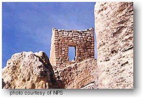
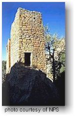
Ranger Station/Square Tower
Square Tower
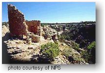
Group Hovenweep Castle is what remains of a large pueblo situated on edge of the canyon rim. Even though it is called a "castle," its use was most likely domestic. There is very little evidence at Hovenweep to support the theory that these structures were built purely for defensive purposes. Square Tower, for which the group is named, is a three story high tower that sits upon a sandstone rock below Hovenweep Castle. Its location near the spring at the head of the canyon gives rise to speculation that it is a ceremonial structure. Hovenweep House is a horseshoe-shaped building near the remains of check dam on the canyon rim above the spring. Dams were typically built above springs in order to hold water and allow it to slowly percolate down through the sandstone until it reached an impervious layer of shale, from which it flowed into the canyon as a spring. Tower Point, at the center of the Y-shape of the canyon, holds a single round tower that commands a view of the entire area. And while it appears to be a lone tower, the canyon below was once filled with dwellings, and it is likely that other buildings ran right up to it just as at Hovenweep Castle. Across from Tower Point is Eroded Boulder House, a dwelling built within a large boulder. Above that, on the canyon rim, are the Twin Towers, a pair of two-story apartment-type buildings containing sixteen rooms. Across and down the canyon are Stronghold House (at left) and Stronghold Tower, structures that were once connected by a log that bridged a crevice in the canyon. Beyond Stronghold House is Unit-Type House, a dwelling similar to the unit pueblos of Mesa Verde (blocks of rooms with a southern kiva and a trash dump south of that). Openings in the east wall of Unit-Type House are arranged to allow a determination of the solstices, equinoxes, and perhaps even moon cycles.
Also at Holly is the most dramatic example of how these people determined the solstice and equinox by tracking the sun's position. Tucked under a rock ledge are markers consisting of a complete spiral, a partial spiral, and a complete three-ring concentric circle. Daggers of light appear on these petroglyphs as the sun rises, aligning on the three designs to mark the summer solstice and the fall and spring equinoxes. As farmers, it was vital to know when it was time to plant crops, and astronomical devices such as this are found at nearly all the sites, usually in the form of holes in the eastern walls of certain structures.
Horseshoe Hackberry Group
Cutthroat Group
Cajon Group
Camping There is a small campground near the ranger station which is open seasonally on a first-come, first-served basis. The sites are designed for tent camping, though a few sites will accommodate RV's 25 feet or less in length. The fee is $10.00 per night. Flush toilets and running water are available. Backpacking is not permitted within Hovenweep.
Hiking The trail system at Hovenweep is primitive and lightly maintained. To protect cultural resources, hiking is limited to established trails only. Hiking trails are available at each of the cultural sites and walking tours are possible with self-guiding trail guides. Trails range in length from a 1/2 mile loop to an 8 mile route that connects two of the cultural site groups.Two trails originate at the Ranger Station and offer visitors the opportunity to view nearby archeological sites: one is a two mile trail that takes about 1.5 hours and has an elevation change of 150 feet; the second trail is shorter and easier.
Photography Hovenweep is a paradise for photographers. The rich colors of the sandstone glow in the crisp sunlight against a sky so blue it seems almost unreal. Abandoned structures cling to the canyon rims, offering themselves for close-ups or cross-canyon shots that will reward even the most amateur picture-taker. And the night sky at Hovenweep is a treasure all its own, with air so clear and free of light-pollution that the Milky Way stretches from horizon to horizon like a jeweled rainbow.
Ranger Station The ranger station contains limited exhibits and educational information for visitors. There is a bookstore specializing in materials on the culture and natural history of the area. A video is available for those not able to take the walking tour of the sites. Picnic tables are available at the Ranger Station Area. Due to the high cost of garbage removal, visitors are required to pack out their own garbage.
Ranger-led Programs Guided hikes and talks are lead by the interpretive staff peridoically spring through fall. Inquire at the ranger station for details and schedules. Interpretive programs can be arranged in advance by contacting the Ranger Station.
|
||||
|
For Additional Information Contact:
Hovenweep National
Monument
|
||||
|
For more information visit the National Park Service website |
||||

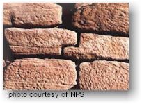 The
masonry found in the Hovenweep area is very distinctive and shows considerable
skill in construction techniques. Structures at other locations in the
region, even the cliff dwellings at Mesa Verde, rarely exhibit such
careful construction and attention to architectural detail. In brief,
the tower walls have the following characteristics:
The
masonry found in the Hovenweep area is very distinctive and shows considerable
skill in construction techniques. Structures at other locations in the
region, even the cliff dwellings at Mesa Verde, rarely exhibit such
careful construction and attention to architectural detail. In brief,
the tower walls have the following characteristics: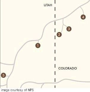
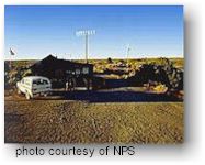 The
ranger station contains limited exhibits and educational information
for visitors. There is a bookstore specializing in materials on the
culture and natural history of the area. A video is available for those
not able to take the walking tour of the sites. Picnic tables are available
at the Ranger Station Area. Due to the high cost of garbage removal,
visitors are required to pack out their own garbage. The Ranger Station
is open from 8:00 a.m.- 4:30 p.m., seven days a week (except for winter
holidays).
The
ranger station contains limited exhibits and educational information
for visitors. There is a bookstore specializing in materials on the
culture and natural history of the area. A video is available for those
not able to take the walking tour of the sites. Picnic tables are available
at the Ranger Station Area. Due to the high cost of garbage removal,
visitors are required to pack out their own garbage. The Ranger Station
is open from 8:00 a.m.- 4:30 p.m., seven days a week (except for winter
holidays). 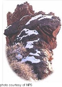 The
most concentrated remains of buildings at Hovenweep are found at Square
Tower Group, spread along both sides of a Y-shaped canyon. Nearly thirty
kin kivas were once scattered along the slopes of this canyon between
the many stone masonry housing units, indicating that perhaps as many
as 500 people once lived in this canyon. There are numerous named buildings
at Square Tower Group, some of which are mentioned below.
The
most concentrated remains of buildings at Hovenweep are found at Square
Tower Group, spread along both sides of a Y-shaped canyon. Nearly thirty
kin kivas were once scattered along the slopes of this canyon between
the many stone masonry housing units, indicating that perhaps as many
as 500 people once lived in this canyon. There are numerous named buildings
at Square Tower Group, some of which are mentioned below.
 The
Holly Group was once the home to an estimated 150 or more people. This
group contains five named buildings: Tilted Tower, Holly Tower, Curved
Wall House, Great House, and Isolated Boulder House. The most spectacular
of these is Holly tower, a graceful two-story structure that was skillfully
built on a tall, narrow boulder. This tower has a single entrance, reachable
only by hand and toe holds carved into the boulder, and represents one
of the finest examples of Montezuma Valley architecture.
The
Holly Group was once the home to an estimated 150 or more people. This
group contains five named buildings: Tilted Tower, Holly Tower, Curved
Wall House, Great House, and Isolated Boulder House. The most spectacular
of these is Holly tower, a graceful two-story structure that was skillfully
built on a tall, narrow boulder. This tower has a single entrance, reachable
only by hand and toe holds carved into the boulder, and represents one
of the finest examples of Montezuma Valley architecture.
 Horseshoe
Ruin was a small village housing only 50 to 60 people. There was a dam
on the canyon rim creating a reservoir, groups of unit houses in the
canyon, and ceremonial structures to the east and west of the main pueblo.
An isolated tower stands on the sandstone point to the west of the main
dwellings, overlooking the canyons to the south as if watching for danger,
but its function was probably ceremonial. The most significant building
at this site is Horseshoe House itself, a D-shaped structure with a
curved wall on one side, subdivided into compartments in the general
pattern of the Sun Temple at Mesa Verde.
Beneath the canyon rim below Horseshoe House is a small cliff dwelling
and kiva, and in the grotto that holds the spring are many well preserved
ancient hand prints.
Horseshoe
Ruin was a small village housing only 50 to 60 people. There was a dam
on the canyon rim creating a reservoir, groups of unit houses in the
canyon, and ceremonial structures to the east and west of the main pueblo.
An isolated tower stands on the sandstone point to the west of the main
dwellings, overlooking the canyons to the south as if watching for danger,
but its function was probably ceremonial. The most significant building
at this site is Horseshoe House itself, a D-shaped structure with a
curved wall on one side, subdivided into compartments in the general
pattern of the Sun Temple at Mesa Verde.
Beneath the canyon rim below Horseshoe House is a small cliff dwelling
and kiva, and in the grotto that holds the spring are many well preserved
ancient hand prints.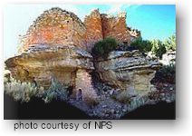 Cutthroat
was a Pueblo III village of substantial size, perhaps having a population
over 200, built on an S-shaped stream that was dammed to provide a small
reservoir between the two sections of the village. Cutthroat differs
from the other site groups in that it is built on a stream bed rather
than clustered around a canyon head spring. Another interesting feature
of several of the towers at Cutthroat is their lack of visible entrances.
Many of these entrances could have been below ground, or the towers
could have been accessed from the top by ladders. This site sits at
the highest elevation of all the Hovenweep group, receiving higher annual
precipitation, cooler temperatures, and having deeper soils than the
other sites.
Cutthroat
was a Pueblo III village of substantial size, perhaps having a population
over 200, built on an S-shaped stream that was dammed to provide a small
reservoir between the two sections of the village. Cutthroat differs
from the other site groups in that it is built on a stream bed rather
than clustered around a canyon head spring. Another interesting feature
of several of the towers at Cutthroat is their lack of visible entrances.
Many of these entrances could have been below ground, or the towers
could have been accessed from the top by ladders. This site sits at
the highest elevation of all the Hovenweep group, receiving higher annual
precipitation, cooler temperatures, and having deeper soils than the
other sites. 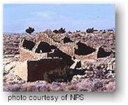 The
Cajon group consists of the ruins of a small village constructed in
the same configuration as Hackberry, Horseshoe, and Holly. The surviving
structures are situated about the head of a small canyon, and the rubble
of other room blocks at the site indicate that about 80 to 100 people
was lived here. Under the ledge of one canyon wall are small cliff dwellings
and pictographs painted in Mesa Verde pottery style, and the remains
of a good-sized earthen dam built in the wash above the spring can still
be seen today. On the western slope of the
canyon stands an exotic circular tower with its walls following the
undulations of three large boulders. The builders of this tower carefully
fitted their masonry stones to the rocks to produce a round building
plan on a remarkably uneven surface. It is a prime example of the skill
and determination of the architects and masons of Hovenweep.
The
Cajon group consists of the ruins of a small village constructed in
the same configuration as Hackberry, Horseshoe, and Holly. The surviving
structures are situated about the head of a small canyon, and the rubble
of other room blocks at the site indicate that about 80 to 100 people
was lived here. Under the ledge of one canyon wall are small cliff dwellings
and pictographs painted in Mesa Verde pottery style, and the remains
of a good-sized earthen dam built in the wash above the spring can still
be seen today. On the western slope of the
canyon stands an exotic circular tower with its walls following the
undulations of three large boulders. The builders of this tower carefully
fitted their masonry stones to the rocks to produce a round building
plan on a remarkably uneven surface. It is a prime example of the skill
and determination of the architects and masons of Hovenweep.