|
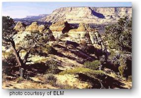
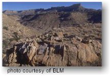
The Grand Staircase--A
Museum of Earth History
 The
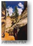
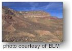
cream- and rose-colored cliffs of Navajo sandstone pictured here are
the third in a series of great geological steps that ascend northward
across the southwest corner of the Monument. This Grand Staircase-the
Chocolate, Vermilion, White, Gray, and Pink Cliffs--spans five different
life zones from Sonoran desert to coniferous forests. It is a masterpiece
of geological and biological diversity. The
cream- and rose-colored cliffs of Navajo sandstone pictured here are
the third in a series of great geological steps that ascend northward
across the southwest corner of the Monument. This Grand Staircase-the
Chocolate, Vermilion, White, Gray, and Pink Cliffs--spans five different
life zones from Sonoran desert to coniferous forests. It is a masterpiece
of geological and biological diversity.
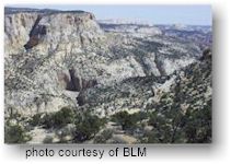
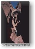
The Canyons of the Escalante--Wonders
in Water and Stone
 The
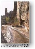
Escalante River cascades off the southern flank of the Aquarius Plateau,
winding through a 1,000-mile maze of interconnected canyons. This magical
labyrinth is one of the scenic wonders of the West. Even though
Spanish explorer and priest Father Silvestre Velez de Escalante never
wet a boot or even saw the river, his is the namesake given by the Powell
survey crew that discovered and named the Escalante River in 1872. The
Escalante River cascades off the southern flank of the Aquarius Plateau,
winding through a 1,000-mile maze of interconnected canyons. This magical
labyrinth is one of the scenic wonders of the West. Even though
Spanish explorer and priest Father Silvestre Velez de Escalante never
wet a boot or even saw the river, his is the namesake given by the Powell
survey crew that discovered and named the Escalante River in 1872.
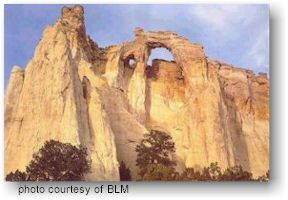
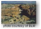
The Kaiparowits Plateau--An
American Outback
 A
vast wedge-shaped block of mesas and deeply incised canyons towers above
the surrounding canyonlands. The isolated, rugged plateau is refuge
for wildlife, rare plants, and a few adventure-ready individuals equipped
to handle profound solitude and uncompromising wild country. "The
Kaiparowits was the name for a point near the north end of the plateau
so we decided to call the whole mountain by that name," wrote A.
H. Thompson. It is a Paiute name meaning "Big Mountain’s Little
Brother." Many sites from prehistoric cultures have been recorded
on the Plateau. Many more are preserved for future study. A
vast wedge-shaped block of mesas and deeply incised canyons towers above
the surrounding canyonlands. The isolated, rugged plateau is refuge
for wildlife, rare plants, and a few adventure-ready individuals equipped
to handle profound solitude and uncompromising wild country. "The
Kaiparowits was the name for a point near the north end of the plateau
so we decided to call the whole mountain by that name," wrote A.
H. Thompson. It is a Paiute name meaning "Big Mountain’s Little
Brother." Many sites from prehistoric cultures have been recorded
on the Plateau. Many more are preserved for future study.
Camping
 Developed
Campgrounds Developed
Campgrounds
Developed campgrounds
may be found at the perimeter of the Monument along Highways 12 and
89. BLM operates 2 developed campgrounds within the Monument, offering
picnic tables, grills, and restrooms. Calf Creek campground, along Highway
12 between Escalante and Boulder, has 13 sites and is also the trail
head for Lower Calf Creek Falls. There is a $7 nightly camping site
fee and a $2 per carload day use fee. Deer Creek campground has 4 sites
and is located 6 miles east of Boulder along the Burr Trail. It has
a $4 nightly camping fee. There is a 14 day stay limit at all BLM sites.
Primitive Camping
Primitive camping continues to be popular in
Escalante Canyons and other parts of the Monument. If you camp at a
site not identified in this brochure, please find a location which shows
signs of prior use as a campsite. Do not camp at trailheads or within
500' of corrals, springs, seeps, or streams.
We strongly recommend
that you use a camp stove. For campfires, a metal fire pan, such as
a garbage can lid or an old barbecue bottom, is recommended. Before
breaking camp, transfer the cold, blackened ashes to your garbage container,
and stow the fire pan in a separate bag. This way, other campers will
find a clean camp for their own enjoyment. Bring your own firewood,
since dead and down wood is important habitat for other creatures, and
please do not take living plant material for any purpose.
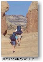
Hiking
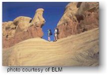 Grand
Staircase-Escalante National Monument covers 1.9 million acres of public
lands in Southern Utah, much of it accessible for hiking. Hiking in
this rugged and remote area is mostly on unmarked routes. Find out what
your skill level is by doing a day hike. Visit with BLM staff and plan
extended hikes accordingly. These lands are rugged and primitive, appealing
to those looking for an adventure. Remoteness, limited travel corridors,
and low visitation have all helped to preserve this type of opportunity. Grand
Staircase-Escalante National Monument covers 1.9 million acres of public
lands in Southern Utah, much of it accessible for hiking. Hiking in
this rugged and remote area is mostly on unmarked routes. Find out what
your skill level is by doing a day hike. Visit with BLM staff and plan
extended hikes accordingly. These lands are rugged and primitive, appealing
to those looking for an adventure. Remoteness, limited travel corridors,
and low visitation have all helped to preserve this type of opportunity.
Hiking Route Descriptions
Escalante/Boulder Area
 Lower
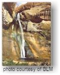
Calf Creek Falls - Map: Calf Creek 7.5 quadrangle. This 2 3/4
mile (one way) interpretive trail begins from the Calf Creek campground
($2 per vehicle day use fee area). This hike is moderately difficult
on a developed sandy trail which ends at 126-foot-high Calf Creek Falls. Lower
Calf Creek Falls - Map: Calf Creek 7.5 quadrangle. This 2 3/4
mile (one way) interpretive trail begins from the Calf Creek campground
($2 per vehicle day use fee area). This hike is moderately difficult
on a developed sandy trail which ends at 126-foot-high Calf Creek Falls.
Escalante
Natural Bridge - Map: Calf Creek 7.5 quadrangle. This easy 2
mile (one way) hike begins from the Highway 12 bridge which crosses
the Escalante River 15 miles east of Escalante. Park at the trailhead
and hike upstream. Numerous river crossings are necessary in ankle to
knee deep water. The natural bridge is on the south side of the canyon.
 Phipps
Wash - Map: Calf Creek 7.5 quadrangle.
This route also begins at the Highway 12 bridge trailhead. Follow the
marked route downstream past private property then hike in and out of
the river until you get to the mouth of Phipps Wash which enters from
the west. Maverick Natural Bridge (approximately 1.5 miles) can be found
in a north side drainage of Phipps wash. Phipps Arch is accessed by
scrambling up a south side drainage. Phipps
Wash - Map: Calf Creek 7.5 quadrangle.
This route also begins at the Highway 12 bridge trailhead. Follow the
marked route downstream past private property then hike in and out of
the river until you get to the mouth of Phipps Wash which enters from
the west. Maverick Natural Bridge (approximately 1.5 miles) can be found
in a north side drainage of Phipps wash. Phipps Arch is accessed by
scrambling up a south side drainage.
 Peek-a-boo
and Spooky Gulches - Map: Big Hollow Wash 7.5 quadrangle.
This is a moderate hike that explores narrow and challenging short slot
canyons. Drive approximately 26 miles south on the Hole-in-the-Rock
road to the signed Dry Fork turnoff on the left. Follow the road, keeping
left, to the parking area. From the rim descend on a cairned route to
the Dry Fork Wash. The canyon to your immediate left is called the Narrows
and does not require scrambling or climbing skills. Peek-a-boo Gulch
is a short distance downstream on your left and requires some climbing,
and scrambling skill. The mouth of Spooky Canyon is approximately ½
mile further downstream from Peek-a-boo and requires less scrambling
skill although it is extremely narrow and may not be suitable for larger
or claustrophobic people. Keep your eyes open for rattlesnakes. All
three canyons can be hiked in a day. Peek-a-boo
and Spooky Gulches - Map: Big Hollow Wash 7.5 quadrangle.
This is a moderate hike that explores narrow and challenging short slot
canyons. Drive approximately 26 miles south on the Hole-in-the-Rock
road to the signed Dry Fork turnoff on the left. Follow the road, keeping
left, to the parking area. From the rim descend on a cairned route to
the Dry Fork Wash. The canyon to your immediate left is called the Narrows
and does not require scrambling or climbing skills. Peek-a-boo Gulch
is a short distance downstream on your left and requires some climbing,
and scrambling skill. The mouth of Spooky Canyon is approximately ½
mile further downstream from Peek-a-boo and requires less scrambling
skill although it is extremely narrow and may not be suitable for larger
or claustrophobic people. Keep your eyes open for rattlesnakes. All
three canyons can be hiked in a day.
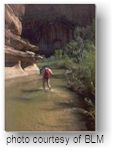 Escalante
River Gorge - Map: Escalante 7.5 & Calf Creek 7.5 quadrangle.
Approximately 15 miles one way, 2 days. The signed trailhead is just
east of Escalante. This moderate hike is in and out of ankle to knee
deep water along the scenic upper Escalante River canyon. There are
opportunities for side trips up Death Hollow and Sand Creek. The hike
ends at the Highway 12 bridge trailhead. Flash floods are always a danger. Escalante
River Gorge - Map: Escalante 7.5 & Calf Creek 7.5 quadrangle.
Approximately 15 miles one way, 2 days. The signed trailhead is just
east of Escalante. This moderate hike is in and out of ankle to knee
deep water along the scenic upper Escalante River canyon. There are
opportunities for side trips up Death Hollow and Sand Creek. The hike
ends at the Highway 12 bridge trailhead. Flash floods are always a danger.
Boulder
Mail Trail - Maps: Escalante 7.5 & Calf Creek 7.5 quadrangle.
Approximately 16 miles one way, 2 days. Most people hike this route
starting at the Boulder Airstrip trailhead off of the Hells Backbone
road. This moderate to strenuous hike requires cross-country route finding
abilities. The Boulder Mail Trail is an historic route that was once
used to deliver mail and supplies by muleback between Escalante and
Boulder. There are spectacular views and expanses of slickrock. It crosses
Sand Creek, Death Hollow and upper Mamie Creek (dry). The route is marked
sporadically by rock cairns and old telegraph wire.
The Gulch / Escalante River to Hwy 12 -
Maps: King Bench 7.5, Red Breaks 7.5 & Calf Creek 7.5 quadrangles.
Approximately 27 miles one way, 3-4 days. This hike starts at The Gulch
trailhead off of the Burr Trail road and ends at the Highway 12 Bridge
trailhead. This moderately strenuous hike has short sections of narrows
in the lower Gulch which require difficult route scrambling, or to climb
up and around on the west canyon rim. Route finding along the river
can be difficult requiring negotiating through brush and tamarisk thickets
along the river. May require deep wading in spots. No reliable water
source in The Gulch during summer months. Flash floods are a danger.
Escalante River Hwy 12 Bridge to Harris Wash
- Maps: Calf Creek 7.5, King Bench 7.5, Red Breaks 7.5 & Silver
Falls 7.5 quadrangles. Approximately 37 miles one way, 4-5 days. This
moderately strenuous hike starts at the Highway 12 Bridge trailhead
and ends at the Harris Wash trailhead off of the Hole-in-the-Rock road.
There is also a difficult route negotiating through brush and tamarisk
thickets between Boulder Creek and The Gulch. This route requires walking
in and out of mid-calf to knee deep water. There are opportunities for
side trips up Boulder Creek, The Gulch, Horse Canyon and Silver Falls
Canyon. Flash floods are definitely a danger.
Wolverine - Maps: Pioneer Mesa 7.5 &
King Bench 7.5 quadrangles. Approximately 5 miles one way. This moderate
hike down Wolverine Canyon to Horse Canyon starts at the Wolverine trailhead
off of the Wolverine Loop road. Water is scarce or non- existent so
plan on carrying all that you will need. The lower end of the canyon
is quite narrow. Be aware of flash flood dangers.
Kanab Area
 Lick
Wash - Maps: Deer Spring Point 7.5 quadrangle. From Kanab drive
east to the Johnson Canyon turnoff from highway 89. Travel north to
the Skutumpah Road turnoff and travel east about 14 miles to Lick Wash.
The mouth of the canyon is located approximately 2 miles from Deer Springs
Ranch. There is no developed trailhead, but hikers can park on the flat
at the mouth of the canyon. The canyon is approximately 3 miles long
with no elevation change making it a fairly easy day hike. Be aware
of flash flood dangers. Lick
Wash - Maps: Deer Spring Point 7.5 quadrangle. From Kanab drive
east to the Johnson Canyon turnoff from highway 89. Travel north to
the Skutumpah Road turnoff and travel east about 14 miles to Lick Wash.
The mouth of the canyon is located approximately 2 miles from Deer Springs
Ranch. There is no developed trailhead, but hikers can park on the flat
at the mouth of the canyon. The canyon is approximately 3 miles long
with no elevation change making it a fairly easy day hike. Be aware
of flash flood dangers.
Starlight
Arch - Maps: Five Mile Valley and Calico Peak. This feature lies
west of the Paria Movie Set, which can be accessed from Highway 89 between
Kanab, Utah and Page, Arizona. There is no established trail to the
arch from the Paria Movie Set. The best way to access the arch is by
hiking up the Paria River. This is a scenic day trip. Be aware of flash
flood dangers.
Willis Creek - Map:
Bull Valley Gorge 7.5 quadrangle. This area can be accessed from the
Skutumpah Road. The creek is located approximately 25 miles northeast
of the Johnson Canyon and Skutumpah road junction. There is no established
trailhead into Willis Creek and both sides of the road are private property.
Parking is available about ½ mile northeast of the creek up the Willis
Creek Road, or to the south of the creek along the Skutumpah Road. The
narrow wash is lined with slickrock and makes for an adventuresome 2
mile day hike. For the more experienced hiker, a loop trip is possible
down Willis Creek and up Sheep Creek to the Skutumpah Road. Flash floods
are a danger.
Cottonwood Creek -
This small slot canyon is located approximately 3 miles south of Grosvenor
Arch along the west side of Cottonwood Canyon Road. The small slot canyon
runs parallel with the road for about ½ mile and makes for a short scenic
one to two hour hike. Although there is no developed trailhead for the
canyon, hikers can park along the side of Cottonwood Canyon Road. Maps:
Butler Valley 7.5 quadrangle.
 Hackberry
Canyon - This 14 mile canyon parallels the Cottonwood Canyon
Road. The mouth of the Canyon is accessible from the Cottonwood Canyon
Road, and is located about 15 miles north of Highway 89. Parking is
available along the Cottonwood Canyon Road. No established trail exists
in the canyon, but the route is self defined through the drainage. The
Canyon offers enchanting one to three day hikes. The canyon is narrow
and increases in elevation heading north. Some rock scrambling is involved.
Several springs are located in the canyon, and can be utilized for drinking
water if treated, however, expect to share them with permitted livestock.
Maps: Calico Peak and Slick Rock Bench 7.5 quadrangle. Hackberry
Canyon - This 14 mile canyon parallels the Cottonwood Canyon
Road. The mouth of the Canyon is accessible from the Cottonwood Canyon
Road, and is located about 15 miles north of Highway 89. Parking is
available along the Cottonwood Canyon Road. No established trail exists
in the canyon, but the route is self defined through the drainage. The
Canyon offers enchanting one to three day hikes. The canyon is narrow
and increases in elevation heading north. Some rock scrambling is involved.
Several springs are located in the canyon, and can be utilized for drinking
water if treated, however, expect to share them with permitted livestock.
Maps: Calico Peak and Slick Rock Bench 7.5 quadrangle.
Paria River/Coyote Buttes
Paria
River/Coyote Gulch Fee Demonstration Project
The Paria
Canyon/Coyote Buttes Recreation Fee Demonstration site is managed as
a partnership by the Arizona Strip Field Office and the Kanab Resource
Area, Bureau of Land Management, Northern Arizona University, and the
Arizona Strip Interpretive Association under the authority of Public
Law 104-134. The project implements a fee/permit system for Paria Canyon,
the White House Campground, and Coyote Buttes. The project uses visitor
generated fees to enhance and maintain wilderness resources and visitor
services.
Mountain Biking
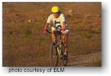 The
Grand Staircase–Escalante National Monument covers 1.9 million acres
of public lands in Southern Utah, with several hundred miles of roads
and trails. Many of the routes are ideal for family or group, vehicle
supported trips. Mountain biking is a refreshing way to experience the
variety of landscapes that the Monument has to offer. These lands are
rugged and primitive, appealing to those looking for an adventure. Remoteness,
limited travel corridors, and low visitation have all helped to preserve
this type of opportunity. The
Grand Staircase–Escalante National Monument covers 1.9 million acres
of public lands in Southern Utah, with several hundred miles of roads
and trails. Many of the routes are ideal for family or group, vehicle
supported trips. Mountain biking is a refreshing way to experience the
variety of landscapes that the Monument has to offer. These lands are
rugged and primitive, appealing to those looking for an adventure. Remoteness,
limited travel corridors, and low visitation have all helped to preserve
this type of opportunity.
Route Descriptions
Escalante/Boulder Area
Cedar
Wash Loop - From Escalante ride east on Highway 12 to the Hole
in the Rock Road and follow the signs to Cedar Wash Road which returns
to town. Fairly level route with views of the Straight Cliffs and access
(short hikes) to two natural arches. Approximately 20 miles round trip.
Use Dave Canyon 7.5 quadrangle map.
Alvey
Wash Loop - From Escalante follow the Smoky Mountain (Alvey Wash)
Scenic Byway south to Little Valley Wash and return north to Highway
12 on the Pet Hollow road. A scenic ride through the upper canyons of
the Kaiparowits Plateau. Approximately 32 miles round trip, 600-foot
elevation gain. Use Dave canyon, Death Ridge, and Canaan Creek 7.5 quadrangle
maps.
Wolverine / Circle Cliffs Loop
- This tour leaves the Burr Trail 19 miles east of Boulder. Ride south
on the Wolverine Canyon road which loops back to the Burr trail after
29 miles. Complete the loop by riding west on the Burr Trail 14 miles.
This ride features spectacular views of the Circle Cliffs, the Wolverine
Petrified Wood Natural Area, Little Death Hollow, and historic uranium
mines. Many good camping sites. Approximately 43 miles round trip, fairly
level route. Use Lamp Stand, Pioneer Mesa, Wagon Box, and Bitter Creek
Divide 7.5 quadrangle maps.
 Egypt
- Begin from Hole in the Rock Road 16.5 miles south of Highway 12. Ride
east, crossing Twentyfive Mile Wash, to the Egypt Trailhead (mountain
bikes are not allowed on the trail). Outstanding views of the Escalante
River Canyons. Approximately 10 miles one way, 300-foot elevation gain,
Use Egypt 7.5 quadrangle map. Egypt
- Begin from Hole in the Rock Road 16.5 miles south of Highway 12. Ride
east, crossing Twentyfive Mile Wash, to the Egypt Trailhead (mountain
bikes are not allowed on the trail). Outstanding views of the Escalante
River Canyons. Approximately 10 miles one way, 300-foot elevation gain,
Use Egypt 7.5 quadrangle map.
 Fiftymile
Bench - Begin from Hole-in-the-Rock Road at Willow Tank, 34.2
miles south of Highway 12. This route heads up Willow Tank slide to
Fiftymile Bench, south along the bench, and descends down Sooner Slide
to Hole-in-the-Rock Road. Return north to Willow Tank. The route follows
the Straight Cliffs high above the desert floor with far vistas of the
Escalante River Canyons, Henry Mountains, and Glen Canyon Country. Approximately
27 miles round trip, strenuous elevation gain of 500 feet. Use Big Hollow
Wash, Blackburn Canyon, and Sooner Bench 7.5 quadrangle maps. Fiftymile
Bench - Begin from Hole-in-the-Rock Road at Willow Tank, 34.2
miles south of Highway 12. This route heads up Willow Tank slide to
Fiftymile Bench, south along the bench, and descends down Sooner Slide
to Hole-in-the-Rock Road. Return north to Willow Tank. The route follows
the Straight Cliffs high above the desert floor with far vistas of the
Escalante River Canyons, Henry Mountains, and Glen Canyon Country. Approximately
27 miles round trip, strenuous elevation gain of 500 feet. Use Big Hollow
Wash, Blackburn Canyon, and Sooner Bench 7.5 quadrangle maps.
Big Water Area
Nipple
Loop - This route leaves Big Water and heads north along Nipple
Creek Wash to Nipple Butte (approximately 14 miles one way). From Nipple
Butte a loop can be made down Tibbet Canyon (approximately 12 miles).
Views of Smoky Mountain, lower Kaiparowits Plateau, and Lake Powell.
Be prepared for steep climbs. Roads not passable when wet. Use Nipple
Butte and Tibet Bench 7.5 quadrangle maps.
Smoky Mountain/Smokey Hollow Loop - From
Big Water ride east on the Warm Creek Road into Glen Canyon National
Recreation Area to the intersection with the Smoky Mountain / Smoky
Hollow Roads (approximately 16 miles one way). Continue north up Warm
Creek / Smoky Hollow to the Smoky Mountain Road and return south on
this road to Glen Canyon National Recreation Area (approximately
31 miles). This route is long and strenuous. Outstanding canyons and
views of Lake Powell. Roads are not passable when wet. Use Smoky Hollow
and Sit Down Bench 7.5 quadrangle maps.
South Cottonwood Canyon - Access to the
Cockscomb and lower Cottonwood Canyon from Highway 89 or Highway 12.
A well-traveled road with interesting geologic formations and shady
cottonwood groves. Approximately 46 miles from Highway 89 to Kodachrome
Basin State Park. Be prepared for steep climbs. The ride is easier starting
at Kodachrome Basin and riding south. The road is not passable when
wet. Use Lower Coyote Springs, Horse Flat, Butler Valley, and Slick
Rock Bench 7.5 quadrangle maps.
Paria Movie
Set - From Highway 89 ride north approximately 6 miles to the
Paria Movie Set. Across the Paria River is the ghost town of Old Pahreah.
Return the same route to Highway 89. Steep climb out of the Paria Valley.
Road not passable when wet. Use Five Mile Valley 7.5 quadrangle.
Cannonville
Area
Grosvenor
Arch/Long Flat Loop - Begin at Kodachrome Basin State Park and
ride east following the signs to Grosvenor Arch (approximately 13 miles).
From Grosvenor Arch a loop can be made by continuing south and east
6 miles to Long Flat, turn south for 2.5 miles. Turn west for 4 miles
to the spring and return north 6 miles to Grosvenor Arch. Be prepared
for steep climbs. Roads are not passable when wet. Use topo quads Butler
Valley, Horse Flat, 4 Mile Bench.
Kanab Area
Johnson
Canyon / Skutumpah Roads - The Johnson Canyon Road, 11 miles
east of Kanab on Highway 89, provides access to the canyons and terraces
of the Grand Staircase. Many rides of varying lengths can be made from
Johnson Canyon and Skutumpah roads. It’s approximately 65 miles from
Highway 89 to Cannonville on Highway 12. Be prepared for steep climbs.
The Skutumpah Road is not passable when wet. Use topo quads Skutumpah
Creek, Deer Springs Point, Deer Range Point, Bull Valley Gorge, and
Cannonville.
Sand Gulch - This route
follows an existing road that presents a back way in to the Paria Movie
Set. For mountain bike riders, this is a great route as traffic is low.
The route can be accessed from Highway 89. The turn off for the ride
is at the corral one mile west of the Paria Movie Set turn off. The
corral area offers plenty of space to park and unload bikes. The route
follows the road out of the corral heading west for about a mile and
a quarter, then makes a sharp turn back to the east, ending at the Paria
Movie Set. The route provides a good afternoon ride for a round- trip
of 12 miles to and back from the Movie Set. There are no steep elevation
changes, but there is a wide wash to cross to get into the Movie Set.
Topo quads Eight-Mile Pass and Five- Mile Pass and Five-Mile Valley.
Horseback
Riding
 The
Monument offers numerous opportunities to experience the backcountry
by horse. The varied landforms provide horse riders with a variety of
challenging terrain for all skill levels. These lands are rugged and
primitive, appealing to those looking for adventure. Remoteness, limited
travel corridors, and low visitation have all helped to preserve this
type of opportunity. The
Monument offers numerous opportunities to experience the backcountry
by horse. The varied landforms provide horse riders with a variety of
challenging terrain for all skill levels. These lands are rugged and
primitive, appealing to those looking for adventure. Remoteness, limited
travel corridors, and low visitation have all helped to preserve this
type of opportunity.
Route Descriptions
Escalante/Boulder Area
The
Lower Gulch - Map: King Bench 7.5 quadrangle. This ride begins
along the Burr Trail. It is a picturesque canyon ride which follows
the stream bed for approximately 5 ½ miles downstream before it becomes
impassable to horses. In several areas the route narrows and you may
encounter boggy conditions and quicksand. Water is usually reliable
in the upper end of the canyon, but dries up in the lower end during
the summer months. Deerflies are a definite problem in late May, June
and July. Flash floods are always a possibility.
Deer Creek - Map: King Bench 7.5 quadrangle.
Approximately 7 miles one way. This route begins near the Deer Creek
campground off of the Burr Trail road. Once you leave Deer Creek there
is no water, even in The Gulch, unless you ride early in the year (before
late June). Route is over slickrock and deep sand, some areas are quite
steep. This ride is only for experienced riders and horses in good trail
shape. You can combine The Gulch and Deer Creek to make a longer ride.
The Lower Gulch/Horse Canyon/Escalante River/Silver
Falls Route - Map: King Bench 7.5, Red Breaks 7.5 & Silver
Falls 7.5 quadrangles. Approximately 25 miles one way, 4-5 days. This
is a very strenuous route beginning at The Gulch trailhead (see previous
route descriptions). You exit The Gulch and go across King Bench to
descend into Horse canyon on a steep, hazardous route. Then ride downstream
in Horse Canyon to the Escalante River where you should expect to encounter
quicksand in places and areas of dense willow and tamarisk. The route
up Silver Falls Canyon (in Glen Canyon National Recreation Area) has
some intermittent water part of the year but by late spring expect it
to be dry. This ride should not be attempted except by very experienced
riders and horses, and only when trail is in good condition.
Kanab Area
The
Lower Gulch - Map: King Bench 7.5 quadrangle. This ride begins
along the Burr Trail. It is a picturesque canyon ride which follows
the stream bed for approximately 5 ½ miles downstream before it becomes
impassable to horses. In several areas the route narrows and you may
encounter boggy conditions and quicksand. Water is usually reliable
in the upper end of the canyon, but dries up in the lower end during
the summer months. Deerflies are a definite problem in late May, June
and July. Flash floods are always a possibility.
Deer Creek - Map: King Bench 7.5 quadrangle.
Approximately 7 miles one way. This route begins near the Deer Creek
campground off of the Burr Trail road. Once you leave Deer Creek there
is no water, even in The Gulch, unless you ride early in the year (before
late June). Route is over slickrock and deep sand, some areas are quite
steep. This ride is only for experienced riders and horses in good trail
shape. You can combine The Gulch and Deer Creek to make a longer ride.
The Lower Gulch/Horse Canyon/Escalante River/Silver
Falls Route - Map: King Bench 7.5, Red Breaks 7.5 & Silver
Falls 7.5 quadrangles. Approximately 25 miles one way, 4-5 days. This
is a very strenuous route beginning at The Gulch trailhead (see previous
route descriptions). You exit The Gulch and go across King Bench to
descend into Horse canyon on a steep, hazardous route. Then ride downstream
in Horse Canyon to the Escalante River where you should expect to encounter
quicksand in places and areas of dense willow and tamarisk. The route
up Silver Falls Canyon (in Glen Canyon National Recreation Area) has
some intermittent water part of the year but by late spring expect it
to be dry. This ride should not be attempted except by very experienced
riders and horses, and only when trail is in good condition.
|