

|
|
|
History | Camping | Climbing | Driving Tours | Hiking | Mountain Biking
|
|
|
|
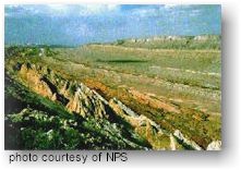
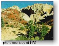
Description Called "Wayne Wonderland" in the 1920s by local boosters Ephraim P. Pectol and Joseph S. Hickman, Capitol Reef National Park comprises 378 square miles of colorful canyons, ridges, buttes, and monoliths. About 75 miles of the long up-thrust called the "Waterpocket Fold", extending like a rugged spine from Thousand Lake Plateau southward to Lake Powell, is preserved within the park boundary. "Capitol Reef" is the name of an especially rugged and spectacular park of the Waterpocket Fold near the Fremont River. |
Park Information Operating Hours: Entrance Fee: Permits: Location: Weather & Climate: Capitol Reef Visitor
Center: For more information contact the visitor center at (435) 425-3791 ext. 111
|
|
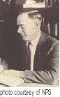
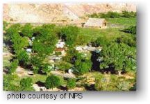
EARLY HISTORYOnly a few decades ago, Capitol Reef and the Waterpocket Fold country comprised one of the remote corners of the "lower 48". Easy road access came only with the construction of a paved Utah Hwy 24 through the Fremont River Canyon in 1962.The earliest traces of human activity date from the 9th century when Indian peoples occupied the flood plains and high ground near the few perennial watercourses. These people - called the Fremont Culture by archeologists - were contemporaries of the pueblo-building Anasazi of the Four Corners area but were less advanced. In the 13th century, all Indian cultures in this area underwent sudden change; the Fremont Indian settlements and fields were abandoned. No one is sure what happened to these Fremont hunter-farmers. Not for several centuries did significant human activity reappear. When the first white explorers traveled in the vicinity of the Waterpocket Fold, both Utes and Southern Paiute nomads were encountered. Despite the fact that numerous expeditions passed near Capitol Reef, none of them explored the Waterpocket Fold to any great extent. It was, as now, incredibly rugged and forbidding. Following the Civil War, Mormon church officials at Salt Lake City sought to establish "missions" in the remotest niches of the intermountain west. In 1866, a quasi-military expedition or Mormons in pursuit of marauding Indians penetrated the high valleys to the west. In the 1870s, settlers moved into these valleys, eventually establishing Loa, Fremont, Lyman, Bicknell, and Torrey. Meanwhile, men from the expeditions of Major John Wesley Powell had begun to explore the area. In the early 1880s, settlers moved into Capitol Reef country. Tiny communities sprung up along the life-sustaining Fremont River; Junction (later "Fruita"), Caineville and Aldridge were created. Fruita prospered, Caineville barely survived, Aldridge died. By 1920, the work was hard but the life in Fruita was good. No more than ten families at one time were sustained by the fertile flood plain of the Fremont River and the land changed ownership over the years. The area remaind isolated. THE "FATHER OF CAPITOL REEF NATIONAL MONUMENT"  Ephraim
Porter Pectol was born in 1875. As a child he lived in Caineville, another
abortive Mormon settlement 20 miles east ot Capitol Reef. In 1910, he
went into business in Torrey and operated a store there for many years.
He served as Mormon Bishop of Torrey from 1911 until 1928. Ephraim
Porter Pectol was born in 1875. As a child he lived in Caineville, another
abortive Mormon settlement 20 miles east ot Capitol Reef. In 1910, he
went into business in Torrey and operated a store there for many years.
He served as Mormon Bishop of Torrey from 1911 until 1928.
Pectol was sensitive to the rugged beauty of the Capitol Reef area and was an avid Fremont culture relic hunter. A private museum in his Torrey store was widely known. Pectol was anxious that the "outside world" should come to appreciate the beauty of the area. In 1921, he organized a "Boosters Club" in Torrey. Pectol pressed a promotional campaign, furnishing stories and photos to periodicals and newspapers. In his efforts, he was increasingly aided by his brother-in-law, Joseph S. Hickman, who was Wayne County High School principal.
Pectol was elected to the presidency of the "Associated Civics Club of Southern Utah", successor to the Wayne Wonderland Club. The club raised $150.00 to interest a Salt Lake City photographer in taking a series of promotional photos. For several years, the photographer - J.E. Broaddus - traveled and lectured on "Wayne Wonderland". In 1933, Pectol himself was elected to the legislature and almost immediately contacted President Roosevelt and asked for the creation of "Wayne Wonderland National Monument" out of the federal lands comprising the bulk of the Capitol Reef area. Federal agencies began a feasibility study and boundary assessment. Meanwhile, Pectol not only guided the government investigators on numerous trips, but escorted an increasing number of visitors. The lectures of Broaddus were having an effect. On August 2, 1937, President Roosevelt signed a proclamation creating Capitol Reef National Monument.
Cathedral Valley
Campground Cedar Mesa Campground Fruita Campground
Rock TypeThe rock at Capitol Reef is comprised predominately of sandstone. It varies in hardness from the soft crumbly Entrada to the relatively hard Wingate. The Wingate cliff walls are the most popular for climbing, as natural fracturing has created many climbable crack systems. In addition, the hardness of the Wingate lends itself more readily to the successful use of chocks, nuts, and camming devices; however it can flake off easily and be very unpredictable. Climbing in canyon country is not something to be taken lightly.Route DescriptionsTwo published guides cover climbs at Capitol Reef. They are Desert Rock by Eric Bjornstad from Chockstone Press, Inc., 1996 and Rock Climbing Utah by Stewart M. Green from Falcon Publishing, 1998. Both are available for sale at the visitor center bookstore . If you climb a new route and wish to leave a route description contact a ranger at the visitor center.PermitsPermits are not required for climbing. However, if you plan to camp overnight on a climb, you are required to obtain a free backcountry use permit, available at the visitor center.Restrictions and ConcernsCapitol Reef National Park is a clean climbing area. Minimum impact techniques that don't destroy the rock or leave a visual trail are encouraged. The use of white chalk is prohibited. Climbers using chalk must use chalk which closely matches the color of the surrounding rock. The use of power drills is also prohibited. Bolts may only be used to replace existing unsafe bolts. Where it is necessary to leave or replace existing webbing, the webbing should closely match the color of the surrounding rock. Ropes may not be left in place unattended for more than 24 hours, and these ropes must be out of reach from the ground or other points accessible without technical climbing.Closed AreasDue to the abundance of prehistoric rock writings, the section of the rock wall north of Utah Hwy 24 between the Fruita Schoolhouse (Mile 80.6) and the east end of the Kreuger Orchard (Mile 81.4) is closed to climbing. In other areas, climbing is not permitted above or within 100 feet of rock art panels or prehistoric structures. Other areas closed to climbing are: Hickman Natural Bridge and all other arches and bridges, Temple of the Moon, Temple of the Sun, and Chimney Rock.SafetyClimbing during the summer is very hot as temperatures frequently reach the upper 90's to near 100 degrees. Carry plenty of water. Afternoon thunderstorms are common in July and August. Sandstone is weak when wet, so avoid climbing in damp areas or right after a rain. Please climb safely! Many falls have been taken on relatively easy routes because experienced climbers became careless. Please report all accidents or injuries at the visitor center.
Scenic DriveThe Scenic Drive starts at the park Visitor Center and provides access to Grand Wash, Capitol Gorge, Pleasant Creek, and the South Draw Road. The Scenic Drive is a 10 mile paved road with dirt spur roads into Grand Wash and Capitol Gorge that, weather permitting, are accessible to ordinary passenger vehicles. The Scenic Drive is not a loop, so you must return on the same road. Entrance fees of $4 per vehicle are charged for the Scenic Drive. The entrance station is located just south of the campground on the Scenic Drive. There is no entrance fee for holders of Golden Eagle, Golden Age, or Golden Access passes. A free Guide to the Scenic Drive brochure is available at the entrance station. Follow this link for a virtual tour of the Scenic Drive.South Draw RoadThe South Draw Road is a high clearance 4-wheel-drive road that extends from Pleasant Creek to the park boundary near Tantalus Flats. The South Draw Road is rough and rocky, includes several creek crossings, and, in inclement weather, becomes impassable to even 4-wheel-drive vehicles. The South Draw Road is reached by following the Pleasant Creek Road from the end of the Scenic Drive to the crossing at Pleasant Creek. The South Draw Road climbs upward from Pleasant Creek, exits the park, and eventually meets Utah Hwy 12 at 8,500 feet on Boulder Mountain. The access to the South Draw Road from Boulder Mountain is closed in winter, and access from Pleasant Creek is not possible, except during the mildest winters, due to snow.Notom-Bullfrog RoadThe Notom-Bullfrog road intersects Utah Hwy 24 9.3 miles east of the Capitol Reef Visitor Center and extends south to Bullfrog Marina and Glen Canyon National Recreation Area. This dirt road runs along the eastern side of the Waterpocket Fold and offers excellent scenery as well as marvelous hiking opportunities. Access to many of the park's backcountry trails, such as Lower Muley Twist and Halls Creek Narrows can be found off this road. While portions of the road outside the park are paved, the majority of the Notom-Bullfrog road is dirt and subject to changes in weather conditions. Visitors are advised to check with the Visitor Center before setting out.Burr Trail RoadThe Burr Trail road, originally a cattle trail blazed by stockman John Atlantic Burr, extends from the town of Boulder on Utah Hwy 12 to the Notom-Bullfrog Road. Much of the 36.5 mile road lies outside the boundary of Capitol Reef and traverses the Circle Cliffs, as well as spectacular canyon areas such as Long Canyon and The Gulch. The 5.3 mile stretch of road inside Capitol Reef includes a breathtaking set of switchbacks rising some 800 feet in only one- half mile. These switchbacks are not considered suitable for RVs or vehicles towing trailers. From Boulder to the west boundary of Capitol Reef, the Burr Trail road is surfaced. Inside the park it remains a graded dirt road and is subject to change due to weather conditions. Visitors should inquire about road and weather conditions before traveling.Hartnet RoadThe Harnet road, or western half of the Cathedral Valley Loop, begins 11.7 miles east of the Visitor Center off Utah Hwy 24. In order to take this route to Cathedral Valley, visitors must ford the Fremont River soon after leaving the highway, which may require a 4WD vehicle. The remaining 24 miles to the top of the loop afford expansive view of the Blue Flats and the South Desert. The northern end of the loop nears Thousand Lake Mountain, and the geology and topography change greatly with the subsequent gain in elevation. Conditions on the Hartnet road vary widely based on recent weather. At best, high clearance vehicles are recommended and visitors should check with the Visitor Center for the most current road information.Caineville Wash RoadThe Caineville Wash road, or eastern side of the Cathedral Valley Loop, begins 18.6 miles east of the Visitor Center. By taking this route into Cathedral Valley, visitors avoid the Fremont River Ford on the Hartnet side of the loop; however, those planning on driving the entire loop are encouraged to begin at the River Ford to be certain they are able to make the crossing. 16.5 miles up the road, in Lower Cathedral Valley, are the Temple of the Sun and Moon, massive monoliths rising from the desert floor. Further north in Upper Cathedral Valley, columns of spire-like formations dominate the landscape. Conditions on the Caineville Wash road vary widely based on recent weather. Check with the Visitor Center for current road information.
BACKCOUNTRY HIKING Capitol Reef offers many hiking options for serious backpackers and those who enjoy exploring remote areas. Marked hiking routes lead into narrow, twisting gorges and slot canyons and to spectacular viewpoints high atop the Waterpocket Fold. Popular backcountry hikes in the southern section of the park include Upper and Lower Muley Twist Canyons and Halls Creek. Backcountry hiking opportunities also exist in the Cathedral Valley area and near Fruita...the possibilities are endless! Stop in the visitor center and talk to a ranger if you are interested in a backcountry hike. They can help you pick out a hike that will fit your time and abilities. If you plan to take an overnight hike, you need to obtain a free backcountry permit at the visitor center prior to your trip. Backcountry group size cannot exceed 12 people.
#1 SCENIC DRIVE Rating: Easy to moderate with some hills.Length: 1 to 25 miles. Surface: Paved. The roads into Grand Wash and Capitol Gorge are dirt and follow wash bottoms. Some sections are sandy and rocky. The road to Pleasant Creek is dirt and gravel with rough sections. Description: The Scenic Drive starts at the park Visitor Center and provides access to Grand Wash, Capitol Gorge, Pleasant Creek, and the South Draw Road. You must return on the same road, so the length of your ride depends on where you turn around. Vehicle traffic can be heavy from April through October. The road is narrow and without shoulders, so bicyclists must be alert to approaching vehicular traffic. Consider doing this as a morning or evening ride when traffic is reduced or during the off season. The road has some moderately steep grades. The park entrance station is located just south of the campground on the Scenic Drive. The entrance fee is $4.00 per vehicle and is good for 7 days in Capitol Reef. Bicyclists who have not previously paid the entrance fee must pay when they pass the fee station. Payment is as for a car, i.e.: a family traveling together would pay $4.00. If you are traveling alone the fee would be $2.00. Be sure to pick up a free copy of A Guide to the Scenic Drive at the entrance station. Other park maps and brochures are available at the Visitor Center.
#2 CATHEDRAL VALLEY LOOP Rating: Strenuous with some steep sections.Length: 60+ miles. Surface: The route traverses a variety of road surfaces including dirt, sand, bentonite clay, and rocky areas and also requires a ford of the Fremont River. Description: Riding into the Cathedral Valley can be a very challenging and rewarding experience. This is one of the more remote areas of the park. Finding water is very difficult and summer temperatures can soar over 100 degrees. This ride is best done in the spring or fall. There are steep hills and switchbacks, wash crossings (muddy when flowing), stretches of deep sand and a river ford that is usually 1 to 1 1/2 feet deep. Access to Cathedral Valley is via the Harnet Road (11.7 miles east of the Visitor Center) or the Caineville Wash Road (18.6 miles east of the Visitor Center) on Utah Hwy 24. The park has a 5 site primitive (no water) campground located mid-way through the loop. The campground is run on a first come, first served basis (permits are not required) and is free. For more information on Cathedral Valley, inquire at the Visitor Center or write us an E-Mail message at care_interpretation@nps.gov. #3 SOUTH DRAW ROAD Rating: Strenuous with very steep hills.Length: Depending on route chosen, 12,22, or 52 miles. Surface: The route traverses a variety of dirt, sand, and rocky surfaces and crosses several creeks that may be muddy. Description: This ride is not recommended in the winter or spring months due to deep snow at higher elevations which make the route impassable. If you like fast downhill rides, this trip should satisfy you. The route starts at 8,500 feet on Boulder Moutain and ends in the park at 5,500 feet. Make sure your bike has good brakes. This trip works best if you can shuttle a vehicle to the Pleasant Creek parking area located at the end of the Scenic Drive and then drive to a starting point at the junction of the Bowns Reservoir Road and Utah Hwy 12 on Boulder Mountain. Follow the Bowns Reservoir Road to Jorgeson and Tantalus Flats (bypass the turnoff to the reservoir), and continue on into the park via the South Draw Road. The South Draw Road turns into the Pleasant Creek Road at the Pleasant Creek crossing inside the park. The parking area is located near this point. If you prearranged a vehicle shuttle, your trip will end here. Alternatively, you can ride the entire loop, including 40 miles of paved road along the Scenic Drive and Utah Hwys 24 and 12, back to your starting point on Boulder Mountain. Be sure to carry a map of the area (available at the bookstore in the Visitor Center) as there are side roads that may be confusing.
#4 BOULDER MOUNTAIN / UTAH HWY 12 - BURR TRAIL ROAD / NOTOM - BULLFROG ROAD / UTAH HWY24 LOOP Rating: Very Strenuous with steep climbs.Length: 80 to 125 miles. Surface: The Notom/Bullfrog Road and part of the Burr Trail Road are graded dirt with some sandy stretches and wash crossings that are muddy when flowing. The Notom/Bullfrog Road is paved for the first 5 miles from Utah Hwy 24 to Notom. The Burr Trail Raod is paved form the west park boundary to Boulder. Utah Hwys 12 and 24 are paved. Description: Starting at the Visitor Center and riding west via Utah Hwy 24, 10 miles, to Utah Hwy 12, this loop takes you over the high country on the west flank of Boulder Mountain (9,400 feet in elevation) on Utah Hwy 12, through the Circle Cliffs, across the Waterpocket Fold on the Burr Trail Road, and then up the Strike Valley along the Notom/Bullfrog Road back to Utah Hwy 24. The complete loop includes approximately 70 miles of paved road. A shuttle can shorten the ride and cut out some of the paved sections. The ride along the Burr Trail Road takes you through narrow, sheer walled Long Canyon, across the relatively flat center of the Circle Cliffs areas, and down the steep eastern slope of the Waterpocket Fold via the spectacular Burr Trail Road Switchbacks. Many miles of spur roads are available for exploring in the Circle Cliffs area. Near the top of the Burr Trail Road switchbacks, a short spur road branches north into Upper Muley Twist Canyon. This three mile road follows the wash bottom past several large arches and ends at the Strike Valley Overlook parking area. Bicycles are not permitted beyond this point. From the parking area, a short foot trail leads to a spectacular view of Strike Valley from the top of the Waterpocket Fold. Another hiking route continues through Upper Muley Twist Canyon (9 miles round trip). At the bottom of the Burr Trail Road switchbacks you will encounter an intersection. Turn left (north) here and continue up the Notom/Bullfrog Road through Strike Valley. The Notom/Bullfrog Road parallels the east flank of the Waterpocket Fold with its steep upthrust of dome topped cliffs. The road continues north approximately 40 miles to the junction of Utah Hwy 24. Take Utah Hwy 24 west 9 miles to the Visitor Center. The park has a 5 site primitive (no water) campground located approximately 12 miles north of the Burr Trail Road junction on the Notom/Bullfrog Road. The campground is run on a first come, first served basis (permits are not required) and is free.
|
||
|
For Additional Information Contact:
Capitol Reef National
Park
|
||
|
For more information visit the National Park Service website |
||
 In
1924, Hickman extended community involvement in the promotional effort
by organizing a Wayne County-wide "Wayne Wonderland Club".
In 1924, the educator was elected to the Utah State Legislature.
In
1924, Hickman extended community involvement in the promotional effort
by organizing a Wayne County-wide "Wayne Wonderland Club".
In 1924, the educator was elected to the Utah State Legislature.
 Traditionally,
Capitol Reef National Park has experienced minimal use by technical
rock climbers. However, recent years have seen an increase in climbing
in Utah's canyon country. Included here are the park regulations and
concerns regarding technical climbing.
Traditionally,
Capitol Reef National Park has experienced minimal use by technical
rock climbers. However, recent years have seen an increase in climbing
in Utah's canyon country. Included here are the park regulations and
concerns regarding technical climbing. 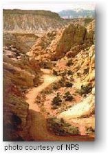
 DAY
HIKING
DAY
HIKING