
|
|
|
History
| Places |
Backpacking | Biking |
Boating | Camping |
Climbing
4WD | Hiking
| Ranger Programs | Scenic Drives
|
Description Canyonlands National Park preserves a colorful landscape of sedimentary sandstones eroded into countless canyons, mesas and buttes by the Colorado River and its tributaries. Located in southeast Utah, the park sits in the heart of a vast basin bordered by sheer cliffs of Wingate Sandstone. The Colorado and Green rivers divide the park into four districts: the Island in the Sky, the Needles, the Maze and the rivers themselves. While the districts share a primitive desert atmosphere, each retains its own character and offers different opportunities for exploration and the study of natural and cultural history. Most visits to Canyonlands involve camping along the trails, roads and rivers found here. The four districts are not directly linked by any roads, so travel between requires two to six hours by car. Generally, people find it impractical to visit more than one or two districts in a single trip.
|
Park Information Operating Hours/Seasons: The park is open year-round. Visitor centers are open daily from 8 a.m. to 4:30 p.m., with extended hours spring through fall. Visitor centers are closed December 25th. Directions: There are two paved entrances into Canyonlands. Highway 313 leads to the Island in the Sky District and is 10 miles north of Moab. Highway 211 leads to the Needles District and is 40 miles south of Moab. Fees: Permits: Weather: Canyonlands is located in a high desert, with cold winters and hot summers (highs frequently over 100 degrees F). Temperatures are mild during spring and fall.
|
|||
|
Human Prehistory
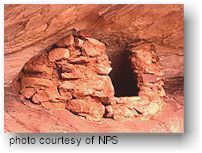
Hunter-GatherersThe first humans known to visit Canyonlands were Paleoindians, who searched for large game animals and edible plants as long as 10,000 years ago. While some of their projectiles have been found in the park, it was not until about 5,000 years ago that people routinely lived in the area. During the time period from about 5000 to A.D. 250, people continued to gather wild plants and animals, utilizing stone tools and throwing devices like the atlatl. The importance of grasses is recorded on many archaic rock art panels, especially those representative of the "Barrier Canyon" style that can be seen in Horseshoe Canyon. Ancestral PuebloansBy A.D. 250, farming techniques from Mesoamerica had reached the southwest, and the hunter-gatherers were cultivating corn and constructing slab-lined cists for storing the collected grains. Intially, the agriculturalists did not have much use for the hot, dry climate of Canyonlands. However, growing populations in nearby Mesa Verde and new techniques of flood-water farming caused people to take advantage of bottomlands and alluvial banks in many canyons of the southwest. By A.D. 1200, there was a major occupation in Salt Creek Canyon in the Needles District. You can see the storage structures or granaries used by the ancestral puebloans in the Needles District at Roadside Ruin, and at the Island in the Sky on Aztec Butte. Around A.D. 1300, the Ancestral Puebloans left the region and moved south to Arizona and New Mexico, probably due to climatic changes. Utes, Navajos and PaiutesUtes moved into the area as early as A.D. 1300, living without permanent dwellings much like the hunter-gatherers in the Archaic period. Ute, Navajo and Paiute Indians all occupied southern Utah when Spanish explorers entered the area in the late 1700's, though their use of the Canyonlands area appears to have been minimal.
European History Exploration
MappingEuropeans knew little of the Colorado River and its tributaries until 1869, when Major John Wesley Powell completed his first expedition from Green River, Utah through the Grand Canyon. Powell repeated the expedition in 1871-72, continuing his studies of the geological, natural and cultural history of the area. Bert Loper, Charles S. Russell, and E.R. Monett made the first pleasure run down the Colorado River through Cataract Canyon in 1907. Julius Stone was the first to hire a guide, Nathaniel Galloway, to take him down the river in 1909. The first motion pictures of the canyons were filmed by Emery and Ellsworth Kolb on their 1911 trip, and in 1937 Norman Nevills started commercial river trips down the Colorado. SettlementIn March 1883, the Denver & Rio Grande railroad joined with the Rio Grande Western railroad near Green River, Utah, providing rail transportation to southeastern Utah. This, combined with the removal of Native Americans to reservations during the late 1800's and early 1900's, nurtured the growth of farming and ranching communities such as Moab and Bluff. With the Utes removed to the Uinta Reservation, Mormon settlers reclaimed the abandoned pioneer community of Moab, and Mormons from the town of Bluff settled Blanding, Monticello, and La Sal. RanchingThe first Europeans to permanently settle southeast Utah were ranchers. From the 1880's until 1975, much of Canyonlands was used for ranching, and features in each district of the park bear the names of these early cowboys. Deb Taylor, Al Holman, John Shafer and many others grazed both cattle and sheep around what is now the Island in the Sky. Don Cooper, Mel Turner, D.L. Goudelock and Joe Titus ranched the Indian Creek area until 1914, when their holdings under the Indian Creek Cattle Company were bought by a pair of brothers named Scorup and Sommerville. Headquarted at the Dugout Ranch, just outside the Needles District, the Indian Creek Cattle Company operates today under ownership of the Nature Conservancy. The Biddlecomes, Ekkers, Tidwells and Chaffins are names common to the Maze, and A.C. Ekker continues to ranch inside the Orange Cliffs Unit of Glen Canyon National Recreation Area today. In addition to cattle, the rugged country around Canyonlands harbored cattle rustlers and other outlaws. Robbers Roost, a mesa top west of the Maze, served as a secluded refuge for Robert Leroy Parker (Butch Cassidy), Tom and Bill McCarthy, Matt Warner and others. MiningDue to the rugged topography of the Canyonlands area, much of it was accessible only by foot or horse until the Uranium boom of the 1950's. With the growth of the country's nuclear arms program, the Atomic Energy Commission offered monetary incentives for the discovery and delivery of Uranium ore. Certain rock layers in Canyonlands contain Uranium, and prospectors built many exploratory roads on public lands in search of radioactive "gold". Many of these routes, including the White Rim Road at the Island in the Sky, are popular four-wheel-drive roads today; others exist as scars that are slowly revegetating. The Creation of CanyonlandsIn the 1950's and early 60's, Arches National Monument Superintendent Bates Wilson began advocating for the creation of a "Grand View National Park" in what is now Canyonlands. Wilson first visited the area by horse in 1951, and spent four years working on a National Park Service archaeological investigation of the Needles District. The Secretary of the Interior, Stewart Udall, visited the area in 1961, and began lobbying Capitol Hill for a national park on what were then Bureau of Land Management lands. On September 12, 1964, President Lyndon B. Johnson signed Public Law 88-590 establishing Canyonlands National Park "...in order to preserve an area in the State of Utah possessing superlative scenic, scientific, and archaeological features for the inspiration, benefit and use of the public...".Initially consisting of 257,640 acres, the park was expanded in 1971 to its present 337,570 acres.
Island in the Sky
Needles
The Maze
Horseshoe Canyon
Orange Cliffs/Glen Canyon
Cataract Canyon/Lake
Powell
Activities There are many ways to enjoy the wonders of Canyonlands. Most visits involve primitive camping in sites along the park's backcountry trails, roads and rivers. However, the Island in the Sky District offers a variety of easily accessible overloooks and short hiking trails perfect for day trips. Campgrounds and popular backcountry areas are usually full every night from mid-March through Memorial Day and from Labor Day through mid-October.
Sites and ZonesIn order to protect natural and cultural resources and prevent crowding, the backcountry of Canyonlands is divided up into sites and zones, and access to each is limited. There are designated walk-in sites along some heavily traveled hiking trails, mostly in the Needles District, for use by backpackers. In more remote areas, where travel is limited to foot or boat, visitors stay in at-large zones and may choose their own campsites.
Permits are required for all overnight trips in the backcountry. During the spring and fall, demand for permits frequently exceeds the number available. If you plan to visit Canyonlands during peak season, especially to camp along the White Rim Road, it is recommended that you make reservations well in advance. These permits can be reserved starting the second monday in July for the next calendar year. Mountain bikes groups must remain on established roads and camp in designated sites. There is no single track riding in the park.
Above their confluence, the Colorado and Green rivers are Class I flatwater, perfect for canoes, sea kayaks and other shallow- water boats. Below the confluence, the combined flow of both rivers spills down Cataract Canyon with remarkable speed and power, creating a challenging stretch of Class III-V white water. Personal water craft are not permitted on the rivers in Canyonlands. The waters of Lake Powell inundate much of Cataract Canyon below the park boundary, creating a 30-mile stretch of water with no current and frequent, up-canyon winds.
Canyonlands has two developed campgrounds, both available on a first-come, first-served basis only. Vault toilets, picnic tables, and grills are provided. Campgrounds typically fill daily from late March through June and again from early September to mid-October. Squaw Flat Campground
(Needles District) Willow Flat Campground
(Island District) Group CampsitesThe Needles District has an additional three campsites for groups of 11 or more people, which may be reserved in advance for a fee of $10. Nightly fees are $3 per person. • Squaw Flat (50 people, 10 vehicles) Outside the ParkDead Horse Point State Park, which has a 21-site campground, is located on Utah 313 approximately 35 miles from Moab, near the Island in the Sky District of Canyonlands. Drinking water, flush toilets, picnic tables and grills are provided. Reservations may be made 3-120 days in advance by calling the Utah State Parks reservation office at (800)322-3770. Camping is allowed in many Bureau of Land Management (BLM) areas outside the park. Some restrictions apply. Contact the nearest BLM office for more information: Grand Resource Area
(outside Island): (435) 259-6111
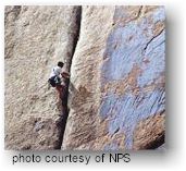
RegulationsTechnical rock climbing is prohibited in the Salt Creek Archeological District in the Needles, in the Horseshoe Canyon Unit of the Maze District, into any archeological site or cultural resource, or on any arch or natural bridge in Canyonlands National Park or the Orange Cliffs Unit of Glen Canyon NRA named on a USGS map, with the exception of Washer Woman Arch at the Island. The intentional removal of lichen or plants from rock is prohibited. The physical altering of rock faces by chiseling, glue reinforcement of existing holds, and gluing of new holds is prohibited. The use of motorized power drills is prohibited. All climbing shall be free or clean aid climbing with the following exceptions:
Canyoneering (cross-country travel involving the occasional use of climbing equipment ) may occur in areas closed to rock climbing, but must occur at least 300 feet away from cultural sites.
Permits are required for all overnight trips in the backcountry. During the spring and fall, demand for permits frequently exceeds the number available. If you plan to visit Canyonlands during peak season, especially to camp along the White Rim Road, it is recommended that you make reservations well in advance. These permits can be reserved starting the second Monday in July for the next calendar year. All vehicles must remain on established roads and must be "street legal." ATVs are not permitted. High-clearance, four-wheel-drive vehicles and some experience are required for most backcountry roads. Other vehicles (e.g. low-clearance all-wheel-drive or high-clearance 2WD) usually have difficulty negotiating the rough slickrock, loose rocks, deep sand and steep switchbacks found throughout the park.
Trails are usually marked with cairns (small rock piles) and have signs at intersections. Many remote trails do not receive regular maintenance and may not be adequately marked. All backcountry hikers should carry a topographic map.
Rangers conduct evening programs and interpretive talks April through October at the Island in the Sky and Needles districts. Schedules are posted at visitor centers and campgrounds. Rangers also lead guided hikes in Horseshoe Canyon April through October. Walks depart the west rim parking lot Saturday and Sunday at 9am. Special walks or programs may be arranged for groups of 20 or more by contacting the districts directly: Island in the Sky: (435)
259-4712
Several short trails, including Mesa Arch, Upheaval Dome and Aztec Butte, lead to unique natural and cultural resources. Plan on spending at least an hour in the park to drive out to Grand View Point. More time is needed to enjoy the other overlooks or explore some of the short hiking trails.
|
||||
|
For Additional Information Contact:
Canyonlands National
Park |
||||
|
For more information visit the National Park Service website |
||||
 The
rugged canyons of what is now Canyonlands National Park have witnessed
many human events since the earliest Americans. Paleoindians first entered
the region around 10,000 years ago. Since then, the tides of human occupation
have ebbed and flowed in concert with the availability of various resources
and the technology to take advantage of those resources.
The
rugged canyons of what is now Canyonlands National Park have witnessed
many human events since the earliest Americans. Paleoindians first entered
the region around 10,000 years ago. Since then, the tides of human occupation
have ebbed and flowed in concert with the availability of various resources
and the technology to take advantage of those resources.
 People
have visited what is now Canyonlands National Park for over 10,000 years.
Over time, various groups moved in and out of the area in concert with
the availability of natural resources and the technology for exploiting
those resources.
People
have visited what is now Canyonlands National Park for over 10,000 years.
Over time, various groups moved in and out of the area in concert with
the availability of natural resources and the technology for exploiting
those resources.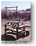 In
the 1770's, the Escalante and Dominguez parties circled Canyonlands,
looking for a route between Santa Fe, New Mexico and Monterey, California.
Though southern Utah was recognized as a Spanish possession with the
signing of the Adams Onis treaty in 1819, this did not deter French
and American trappers from entering the area in the early 1800's. From
1836 through 1838, a trapper named Denis Julien carved his name throughout
the Canyonlands area, including in the Colorado River canyon. The U.S.
Army sent Captain John N. Macomb on an expedition to explore the Colorado
Plateau for a wagon route from New Mexico to Utah in 1859. The expedition
members drew the first accurate maps of southeast Utah, and compiled
geographical and geological information of the area. river
In
the 1770's, the Escalante and Dominguez parties circled Canyonlands,
looking for a route between Santa Fe, New Mexico and Monterey, California.
Though southern Utah was recognized as a Spanish possession with the
signing of the Adams Onis treaty in 1819, this did not deter French
and American trappers from entering the area in the early 1800's. From
1836 through 1838, a trapper named Denis Julien carved his name throughout
the Canyonlands area, including in the Colorado River canyon. The U.S.
Army sent Captain John N. Macomb on an expedition to explore the Colorado
Plateau for a wagon route from New Mexico to Utah in 1859. The expedition
members drew the first accurate maps of southeast Utah, and compiled
geographical and geological information of the area. river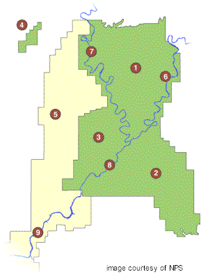
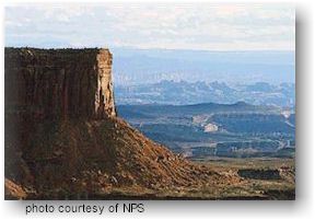
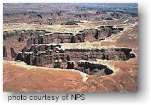 The
Island in the Sky overlooks canyon country from a high mesa top over
a thousand feet above the surrounding terrain. The Island is the easiest
district to visit in a short period of time, offering many pullouts
with spectacular views of the other districts and other features along
the paved scenic drive. Hiking trails and four-wheel-drive roads
access other spectacular views, geological formations, and backcountry
areas for day or overnight trips.
The
Island in the Sky overlooks canyon country from a high mesa top over
a thousand feet above the surrounding terrain. The Island is the easiest
district to visit in a short period of time, offering many pullouts
with spectacular views of the other districts and other features along
the paved scenic drive. Hiking trails and four-wheel-drive roads
access other spectacular views, geological formations, and backcountry
areas for day or overnight trips.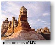 The
Needles forms the southeast corner of Canyonlands and was named for
the colorful spires of Cedar Mesa Sandstone that dominate the area.
Some hiking or four-wheel driving is required to see the district's
main features. An extensive trail system provides many opportunities
for long day hikes and overnight trips. Foot trails and four-wheel-drive
roads lead to such features as Tower Ruin, Confluence Overlook, Elephant
Hill, the Joint Trail, and Chesler Park.
The
Needles forms the southeast corner of Canyonlands and was named for
the colorful spires of Cedar Mesa Sandstone that dominate the area.
Some hiking or four-wheel driving is required to see the district's
main features. An extensive trail system provides many opportunities
for long day hikes and overnight trips. Foot trails and four-wheel-drive
roads lead to such features as Tower Ruin, Confluence Overlook, Elephant
Hill, the Joint Trail, and Chesler Park. The
Maze is the least accessible district of Canyonlands. Due to the district’s
remoteness and the difficulty of roads and trails, travel to the Maze
requires more time, as well as a greater degree of self-sufficiency.
Rarely do visitors spend less than three days in the Maze, and the area
can easily absorb a week-long trip. The
Orange Cliffs Unit of
The
Maze is the least accessible district of Canyonlands. Due to the district’s
remoteness and the difficulty of roads and trails, travel to the Maze
requires more time, as well as a greater degree of self-sufficiency.
Rarely do visitors spend less than three days in the Maze, and the area
can easily absorb a week-long trip. The
Orange Cliffs Unit of 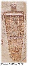 Horseshoe
Canyon is a detached unit of Canyonlands National Park that was added
in 1971. The intriguing rock art in Horseshoe Canyon is considered by
many to be some of the most significant in North America.The Great Gallery,
the best known and most spectacular panel in Horseshoe Canyon, includes
well-preserved, life-sized figures with intricate designs like the one
shown at right. Other impressive sights
include spring wildflowers, sheer sandstone walls and mature cottonwood
groves along the intermittent stream in the canyon bottom.
Horseshoe
Canyon is a detached unit of Canyonlands National Park that was added
in 1971. The intriguing rock art in Horseshoe Canyon is considered by
many to be some of the most significant in North America.The Great Gallery,
the best known and most spectacular panel in Horseshoe Canyon, includes
well-preserved, life-sized figures with intricate designs like the one
shown at right. Other impressive sights
include spring wildflowers, sheer sandstone walls and mature cottonwood
groves along the intermittent stream in the canyon bottom.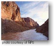 The
Colorado and Green rivers wind through the heart of Canyonlands, cutting
through the layered sandstone to form two deep canyons. Both rivers
are calm upstream of the Confluence, ideal for canoes, kayaks and other
shallow water craft. Below the Confluence, the combined flow of both
rivers spills down Cataract Canyon with remarkable speed and power,
creating a world-class stretch of white water. Personal water craft
are not permitted on the rivers. River flows are dependent upon
snowmelt, and the character of both rivers changes dramatically depending
on the season. High water generally stretches from early May to late
June.
The
Colorado and Green rivers wind through the heart of Canyonlands, cutting
through the layered sandstone to form two deep canyons. Both rivers
are calm upstream of the Confluence, ideal for canoes, kayaks and other
shallow water craft. Below the Confluence, the combined flow of both
rivers spills down Cataract Canyon with remarkable speed and power,
creating a world-class stretch of white water. Personal water craft
are not permitted on the rivers. River flows are dependent upon
snowmelt, and the character of both rivers changes dramatically depending
on the season. High water generally stretches from early May to late
June.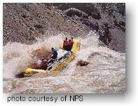 Cataract
Canyon contains fourteen miles of rapids ranging in difficulty up to
Class V. It is a particularly hazardous and isolated section of the
Colorado River and is subject to extreme water level fluctuations.
A permit is required for all trips through Cataract Canyon.
Cataract
Canyon contains fourteen miles of rapids ranging in difficulty up to
Class V. It is a particularly hazardous and isolated section of the
Colorado River and is subject to extreme water level fluctuations.
A permit is required for all trips through Cataract Canyon.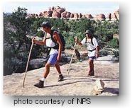 Much
of Canyonlands is managed as undeveloped land, and the park has become
an increasingly popular destination for backcountry travel. Permits
are required for all overnight trips in the backcountry. During the
spring and fall, demand for permits frequently exceeds the number available.
If you plan to visit Canyonlands during peak season, it is recommended
that you make reservations well in advance.
Much
of Canyonlands is managed as undeveloped land, and the park has become
an increasingly popular destination for backcountry travel. Permits
are required for all overnight trips in the backcountry. During the
spring and fall, demand for permits frequently exceeds the number available.
If you plan to visit Canyonlands during peak season, it is recommended
that you make reservations well in advance. Canyonlands
is famous for its mountain biking terrain, particularly for the 100-mile
Canyonlands
is famous for its mountain biking terrain, particularly for the 100-mile
 The
sandstone towers at the
The
sandstone towers at the  There
are hundreds of miles of four-wheel-drive roads in Canyonlands, providing
access to various campsites, trailheads and viewpoints in the park's
backcountry. These roads range in difficulty from intermediate, like
the
There
are hundreds of miles of four-wheel-drive roads in Canyonlands, providing
access to various campsites, trailheads and viewpoints in the park's
backcountry. These roads range in difficulty from intermediate, like
the 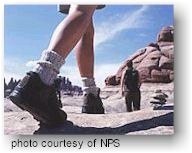 Canyonlands
has hundreds of miles of hiking trails which explore the park’s natural
and cultural features. Both the
Canyonlands
has hundreds of miles of hiking trails which explore the park’s natural
and cultural features. Both the  The
The