|
History
 Human
Prehistory Human
Prehistory
Rocks
have attracted visitors to Arches National Park for thousands of years.
However, sightseeing has not been the main activity for very long. Hunter-gatherers
migrated into the area about 10,000 years ago at the end of the Ice
Age. As they explored Courthouse Wash and other areas in what is now
Arches, they found pockets of chert and chalcedony, microcrystalline
quartz perfect for making stone tools. Chipping or knapping these rocks
into dart points, knives, and scrapers, they created debris piles that
are still visible to the trained eye.
Then, roughly two thousand years ago,
the nomadic hunters and gatherers began cultivating certain plants and
settled into the Four Corners region. These early agriculturalists,
known as the ancestral Puebloan and Fremont people, raised domesticated
maize, beans, and squash, and lived in villages like those preserved
at Mesa Verde National Park.
While no dwellings have been found in
Arches, the northern edge of ancestral Puebloan territory, there are
rock inscription panels. Like earlier people, the ancestral Puebloans
left lithic scatters, often overlooking waterholes where someone may
have shaped tools while watching for game. People living in modern-day
pueblos like Acoma, Cochiti, Santa Clara, Taos, and the Hopi Mesas are
descendants of the ancestral Puebloans.
The Fremont were contemporaries of the
ancestral Puebloans and lived in the same general area, so distinctions
between the two cultures are blurry. However, Fremont rock inscriptions,
pottery and other artifacts clearly demonstrate the existence of different
technologies and traditions. Both the Fremont and the ancestral Puebloans
left the region about 700 years ago.
As the ancestral Puebloan and Fre-mont
peoples were leaving, nomadic Shoshonean peoples such as the Ute and
Paiute entered the area and were here to meet the first Europeans in
1776. The petroglyph panel near Wolfe Ranch is believed to have some
Ute images since it shows people on horseback, and horses were adopted
by the Utes only after they were introduced by the Spanish.
European History
 The
first Europeans to explore the Southwest were Spaniards. As Spain’s
New World empire expanded, they searched for travel routes across the
deserts to their California missions. In fact, the Old Spanish Trail
linking Santa Fe and Los Angeles ran along the same route, past the
park visitor center, that the highway does today. The
first Europeans to explore the Southwest were Spaniards. As Spain’s
New World empire expanded, they searched for travel routes across the
deserts to their California missions. In fact, the Old Spanish Trail
linking Santa Fe and Los Angeles ran along the same route, past the
park visitor center, that the highway does today.
The first reliable date within Arches
is an interesting one. Denis Julien, a French-American trapper with
a habit of chiseling his name and the date onto rocks throughout the
Southwest, left an inscription in this area: Denis Julien, June 9, 1844.
If we only knew what he thought of the wonders he saw!
The first European settlement of Southern
Utah arose from the colonizing efforts of the Mormon Church. The Mormons
attempted to establish the Elk Mountain Mission in what is now Moab
in June of 1855, but conflicts with the Utes caused them to abandon
the effort. In the 1800s and 1890s, Moab was settled permanently by
ranchers, prospectors, and farmers. One settler even found a beautiful
spot within what is now Arches National Park. John Wesley Wolfe, a veteran
of the Civil War, built the homestead known as Wolfe Ranch around 1898,
seeking good fortune in the newly established State of Utah. It is located
on Salt Wash, at the beginning of the Delicate Arch Trail. Wolfe and
his family lived there a decade or more, then moved back to Ohio. The
cabin remains, an echo of what must have been a remarkable experience.
One of the earliest settlers to describe
the beauty of the red rock country around Arches was Loren “Bish” Taylor,
who took over the Moab newspaper in 1911 when he was eighteen years
old. Bish editorialized for years about the marvels of Moab, and loved
exploring and describing the rock wonderland just north of the frontier
town. Some of his journeys were with John “Doc” Williams, Moab’s first
doctor. As Doc rode his horse north to ranches and other settlements,
he often climbed out of Salt Valley to the spot now called Doc Williams
Point, stopped to let his horse rest and looked back over the fabulously
colored rock fins.
Word spread. Alexander Ringhoffer, a
prospector, wrote the Rio Grande Western Railroad in 1923 in an effort
to publicize the area and gain support for creating a national park.
Ringhoffer led railroad executives interested in attracting more rail
passengers into the formations; they were impressed, and the campaign
began. The government sent research teams to investigate and gather
evidence. In 1929, President Herbert Hoover signed the legislation creating
Arches National Monument, to protect the arches, spires, balanced rocks,
and other sandstone formations. In 1971 Congress changed the status
of Arches to a National Park, recognizing over 10,000 years of cultural
history that flourished in this now famous landscape of sandstone arches
and canyons.
Activities
Backpacking
 Arches
is a relatively small park, with very few areas far enough from roads
to qualify as backcountry. Outside the developed areas there are no
designated trails, campsites, or reliable water sources.
In order to backpack in Arches, you must obtain a free
backcountry permit at the visitor center. The maximum group size is
twelve, but smaller groups are strongly recommended to reduce impacts.
Permits may not be reserved in advance. Backpackers should know how
to navigate with a topographic map, recognize safety hazards and practice
low-impact camping specific to the high desert. Primary safety considerations
include steep terrain, loose rock, lightning, flash floods, and dehydration.
Pets may not accompany groups in the backcountry. Arches
is a relatively small park, with very few areas far enough from roads
to qualify as backcountry. Outside the developed areas there are no
designated trails, campsites, or reliable water sources.
In order to backpack in Arches, you must obtain a free
backcountry permit at the visitor center. The maximum group size is
twelve, but smaller groups are strongly recommended to reduce impacts.
Permits may not be reserved in advance. Backpackers should know how
to navigate with a topographic map, recognize safety hazards and practice
low-impact camping specific to the high desert. Primary safety considerations
include steep terrain, loose rock, lightning, flash floods, and dehydration.
Pets may not accompany groups in the backcountry.
Biking
 In
Arches, bicycles are permitted only on roads: there is no single track
or trail riding within the park. Use caution when biking on the main
road. Please ride single file and stay to the edge of the lane. Many
of the dirt roads here are sandy or washboarded; however, the Willow
Springs road offers an enjoyable two to three hour ride. In
Arches, bicycles are permitted only on roads: there is no single track
or trail riding within the park. Use caution when biking on the main
road. Please ride single file and stay to the edge of the lane. Many
of the dirt roads here are sandy or washboarded; however, the Willow
Springs road offers an enjoyable two to three hour ride.
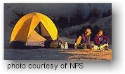
Camping
 The
Devils Garden campground is located eighteen miles from the park entrance
and is open year-round. From mid-March to late October, a $10 per night
fee is charged. From late October to mid-March, the fee is $5 per night. The
Devils Garden campground is located eighteen miles from the park entrance
and is open year-round. From mid-March to late October, a $10 per night
fee is charged. From late October to mid-March, the fee is $5 per night.
Individual campsites are available on
a first-come, first-served basis only. From March to October, visitors
must pre-register for campsites at the entrance station. Pre-registration
begins at 7:30 a.m. (go to the visitor center if the entrance station
is closed). During these months, the campground fills daily, often by
9 a.m.
Campground facilities include potable
water, tables, grills as well as pit-style and flush toilets (water
is turned off during the winter months). There are no showers. Bring
your own wood or charcoal for the grills. Some sites will accommodate
RV's up to 30 feet in length. Check at the visitor center for more information.
Group Sites
The campground has two sites for groups
of eleven or more people. The Juniper Basin campsite will accommodate
up to 55 people; the Canyon Wren campsite up to 35. The group camping
fee is $3 per person per night, with a $33 per night minimum. No recreational
vehicles or trailers are permitted in the group sites.
Group
campsites may be reserved through NRRS year-round. Reservations must
be made no less than 4 days and no more than 360 days in advance. Unreserved
group campsites are available on a first-come, first-served basis on
the day of arrival. To make a reservation, visit
www.Recreation.gov.
Climbing
The rock at Arches offers excellent climbing
opportunities, despite its sandy nature. Most climbing routes in the
park require advanced techniques. Permits are not required, unless the
trip involves an overnight stay in the backcountry.
It the responsibility of all climbers
to know and obey park regulations and route closures (see left margin).
Regulations
- Use of motorized drills is prohibited.
- Climbing is prohibited on any arch
identified on current USGS 7.5 minute topographical maps; on Balanced
Rock year-round; on Bubo from January 1st to June 30th; on Industrial
Disease on the Devil Dog Spire from January 1st to June 30th.
- The use of chalk for climbing must
be of a color which blends with the native rock.
- Climbers are encouraged to employ
clean-climbing ethics, leave dull-colored webbing when recovery
is impossible, and access climbing routes via established trails,
slickrock or sandy washes.
Hiking
Easy Trails
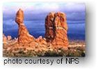 Balanced
Rock Balanced
Rock
A loop trail around the base of a fragile, picturesque
rock formation.
Starting Point: Balanced Rock parking area
Length: 0.3 mile (0.5 km) round trip
Time: 15 to 30
minutes
Broken Arch
Starting Point: Sand Dune Arch parking
area or Devils Garden campground across from campsite #40
Length:
1.2 miles (2 km) round trip; 2 miles (3.2 km) including the loop
Time: 30 to 60 minutes
From the Sand Dune Arch parking area,
the trail cuts across a large meadow to the arch and continues to the
campground. Loop trail leads through fin canyons with sand dunes and
slickrock.
Delicate Arch Viewpoint
Starting Point: Delicate Arch Viewpoint
parking area
Length: 100 yards (91 meters) round trip
Time: 10 to 15 minutes
In addition to the short accessible
trail, another (moderately strenuous) hiking trail climbs one-half mile
(0.8 km) toward Delicate Arch and ends at the rim of a steep canyon
that separates the viewpoint from the arch. (This is not the popular
trail to Delicate Arch, which starts at the Wolfe Ranch parking area.)
Desert Nature Trail
Starting Point: Arches Visitor Center
Length: 0.2 mile (0.3 km) round trip
Time: 15 to 30
minutes
Discover the adaptations of plants and animals in the desert
on a self-guided nature walk. Trail guide available at the trailhead.
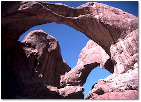
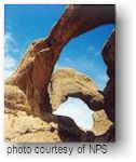
Double Arch
Starting Point: Double Arch parking area
Length: 0.5 mile (0.8 km) round trip
Time: 15 to 30
minutes
A relatively flat, sandy trail leads to the base of two giant
arch spans which are joined at one end.
Landscape Arch
Starting Point: Devils Garden trailhead parking area
Length:
2 miles (3.2 km) round trip
Time: 30 to 60 minutes
A relatively
flat, gravel-surfaced trail (usually heavily populated with hikers)
leads to a spectacular ribbon of rock, whose span is more than a football
field in length. Short side trips to Tunnel and Pine Tree Arches. Trail
guide available at trailhead.
Sand Dune Arch
Starting Point: Sand Dune Arch parking
area
Length: 0.4 mile (0.6 km) round trip
Time:
15 to 30 minutes
Trail leads through deep sand to a secluded arch
among sandstone fins.
Skyline Arch
Starting Point: Skyline Arch parking area
Length: 0.4
mile (0.6 km) round trip
Time: 10 to 20 minutes
A short
hike on a flat, well-defined trail. On a cold November night in 1940,
a large chunk fell out of the arch, instantly doubling the size of its
opening.
 The
Windows The
Windows
Starting Point: Windows parking
area
Length: 1 mile (1.6 km) round trip
Time: 30
to 60 minutes
A gentle climb up a gravel loop trail leads to three
massive arches (North and South Windows and Turret Arch). An alternate
return, slightly longer, is by way of the primitive loop around the
back of the two Windows. The primitive loop trail starts at the South
Window viewpoint.
Moderate Trails
Park
Avenue Trail
Starting Point: Park Avenue parking area
Ending Point: Courthouse Towers parking area
Length:
1 mile (1.6 km) one way
Time: 30 to 60 minutes
Elevation
change: 320 feet (98 meters)
From Park Avenue parking area, the
trail descends steeply into a spectacular canyon and continues down
the wash to Courthouse Towers. If you have a shuttle driver, you can
begin at one point and be picked up at the other. For round-trip hiking,
retrace your steps along the trail rather than walk along the park road.
Tower Arch
Starting Point: Klondike Bluffs parking area,
via the Salt Valley road
Length: 3.4 miles (5.6 km) round
trip
Time: 2 to 3 hours
The trail climbs a steep, but short,
rock wall, cuts across a valley and then meanders through sandstone
fins and sand dunes. An alternate, shorter trail (0.3 mile [0.4 km]
one way), begins at the end of the four-wheel-drive road on the west
side of Tower Arch. This unpaved road washes out quickly in rainstorms;
inquire at the visitor center about road conditions before heading out.
Long Trails
Delicate
Arch
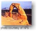 Starting
Point: Wolfe Ranch parking area Starting
Point: Wolfe Ranch parking area
Length: 3 miles (4.8 km)
round trip
Time: 2 to 3 hours
Elevation change:
480 feet (146 meters)
Take at least 1 quart (1 liter) of water per
person! There is no shade. Open slickrock with some exposure to heights.
The first half-mile is a wide, well-defined trail. Upon reaching the
slickrock, follow the rock cairns. The trail climbs gradually and levels
out toward the top of this rock face. Just before you get to Delicate
Arch, the trail goes along a rock ledge for about 200 yards.
Devils
Garden Primitive Loop
Starting Point:
Devils Garden Trailhead parking area
Length: 7.2 miles (11.5
km) round trip, including all points of interest
Time: 3 to
5 hours
Longest of the maintained trails in the park, the Devils
Garden Trail leads to eight awe-inspiring arches. Expect narrow ledges
with rocky surface hiking and scrambling on slickrock. Not recommended
when rock is wet or snowy. Trail guide available at trailhead.
Double O
Arch
Starting Point: Devils Garden
Trailhead parking area
Length: 4 miles (6.4 km) round trip
Time: 2 to 3 hours
Beyond Landscape Arch, the trail becomes
more challenging as it climbs over sandstone slabs; footing is rocky;
there are narrow ledges with exposure to heights. Spur trails lead to
Partition and Navajo Arches. Dark Angel is one-half mile (0.8 km) farther.
Trail guide available at trailhead.
Fiery
Furnace
The Fiery Furnace is a labyrinth of
narrow sandstone canyons and fins. There are no marked trails and the
area has suffered resource damage due to increased visitation.
Visitors who want to explore the Fiery Furnace must obtain a hiking
permit at the visitor center (fee charged) and watch a minimum impact
video. All groups are encouraged to sign up for a
ranger-guided hike.
Photography
 Arches
is a photographer's paradise. The combination of brilliant colors and
unique landforms (many close to the scenic drive), lends itself to picture-taking.
In fact, many features of Arches, especially Delicate Arch, can be seen
on posters and advertisements around the world.
Though there are great spots throughout the park, here
are some recommended locations for visitors who like to leave the scouting
to someone else: Arches
is a photographer's paradise. The combination of brilliant colors and
unique landforms (many close to the scenic drive), lends itself to picture-taking.
In fact, many features of Arches, especially Delicate Arch, can be seen
on posters and advertisements around the world.
Though there are great spots throughout the park, here
are some recommended locations for visitors who like to leave the scouting
to someone else:
Early Morning
Moab Fault, The Three Gossips, Sheep Rock, The Great Wall, Turret Arch,
The Spectacles, Double Arch, Cache Valley, Wolfe Ranch, Double O Arch,
Landscape Arch.
Late Afternoon
Park Avenue, Courthouse Towers, Petrified Dunes, Balanced Rock, The
Garden of Eden, North and South Windows, Delicate Arch, Fiery Furnace,
Skyline Arch, Fins in Devils Garden, Tower Arch.
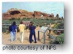
Ranger Programs
 Fiery
Furnace Walks Fiery
Furnace Walks
Rangers lead walks into the
Fiery Furnace twice each day, once in the morning and once in the afternoon.
These 2.5 to 3 hour hikes are moderately strenuous, requiring the occasional
use of hands to scramble through narrow cracks and along narrow ledges.
Visitors are encouraged to accompany a ranger for safety and to reduce
impacts. In order to visit the Fiery Furnace without a ranger, visitors
must obtain a permit (fee charged) at the visitor center.
In order to support the
program, fees are now charged for Fiery Furnace walks. The cost is $6
for adults; $3 for children six to twelve years old and adults sixty-two
or older. Group size is limited, and these popular walks often fill
a day or two in advance. Make your reservation and pay your fee at the
visitor center up to seven days in advance of the walk, and for groups
of no more than ten people. Larger groups can request a special tour
by contacting the park; a minimum of four weeks' notice is advised.
Other Guided Walks
Rangers lead easy, one-hour
walks each day at different locations throughout the park.
Evening Programs
Join a ranger at the Devils
Garden campground amphitheater (next to Canyon Wren group campsite and
across the road from campsite #25) nightly. Programs last about forty-five
minutes.
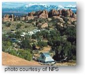
Scenic Drive
 The
road system in Arches passes many outstanding natural features. As Arches'
popularity has increased, people have begun to park in areas that damage
plants and sometimes endanger other visitors. Please park in established
lots only. Generally, parking spaces are easier to find before 9 a.m.
and after 7 p.m. The
road system in Arches passes many outstanding natural features. As Arches'
popularity has increased, people have begun to park in areas that damage
plants and sometimes endanger other visitors. Please park in established
lots only. Generally, parking spaces are easier to find before 9 a.m.
and after 7 p.m.
Drive to the Windows Section
and see some of the park's largest arches. (Add one-half hour to stroll
beneath either North Window or Double Arch.).
or...
Drive
to the Delicate Arch Viewpoint and see the world's most famous arch,
a mile distant. Stop at Wolfe Ranch on your way back and imagine what
it would have been like to homestead this relatively barren area in
the late 1800s.
Junior
Ranger Program
Hey Kids! Tired
of just sitting in the car, looking at that stuff adults call scenery?
Do you want to know more about Arches and help protect the park?
Then the Junior Ranger program is for you!
If you are between the ages of six and twelve, and you
are planning to spend at least one day in Arches, pick up a Junior Ranger
booklet at the visitor center.
You must complete several activities
in the booklet, like word games, drawings and fill-in-the-blanks about
why you shouldn't chase or catch lizards. You must also gather a bag
of litter or bring twenty aluminum cans to be recycled and attend a
ranger program or watch the slide program at the visitor center.
It's that simple! Once you're
finished, you can pick up your badge at the visitor center.
Becoming
a Junior Ranger is a serious and important task, but it's lots of fun
too! Check it out!
|