

|
|
|
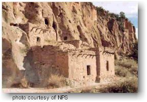 Pueblo dwellings at Bandelier National Monument |
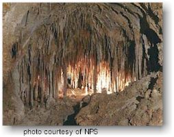 Doll's Theater at Carlsbad Caverns National Park |
| Aztec
Ruins National Monument - Aztec Ruins National
Monument reserves structures and artifacts of Ancestral Pueblo people
from the 1100's through 1200s. People associated with Chaco Canyon to
the south built and used the structures, then people related to the Mesa
Verde region to the north used the site in the 1200's.
Bandelier National Monument - On the canyon-slashed slopes and bottoms of the Pajarito Plateau are the ruins of many cliff houses and pueblo style dwellings of 13th-century Pueblo Indians. Capulin Volcano National Monument - Capulin Volcano, a nearly perfectly-shaped cinder cone, stands more than 1200 feet above the surrounding High Plains of northeastern New Mexico. The volcano is long extinct, and today the forested slopes provide habitat for mule deer, wild turkey, black bear and other wildlife. Abundant displays of wildflowers bloom on the mountain each summer. A 2-mile paved road spiraling to the volcano rim makes Capulin Volcano one of the most accessible volcanoes in the world. Trails leading around the rim and to the bottom of the crater allow a rare opportunity to easily explore a volcano. Carlsbad Caverns National Park - Established to preserve Carlsbad Cavern and numerous other caves within a Permian-age fossil reef, the park contains over 85 known caves, including Lechuguilla Cave—the nation's deepest limestone cave at 1,567 feet (478m) and third longest. Carlsbad Cavern, with one of the world's largest underground chambers and countless formations, is highly accessible, with a variety of tours offered year-round. Chaco Culture National Historical Park - Chaco Culture National Historical Park preserves one of America's richest and most facinating cultural and historic areas. Chaco Canyon was a major center of ancestral Puebloan culture between A.D. 850 and 1250. It was a hub of ceremony, trade, and government for the prehistoric Four Corners area - and a phenomenon unlike anything before or since. El Malpais National Monument - This monument preserves 114,277 acres of which 109,260 acres are federal and 5,017 acres are private. El Malpais means "the badlands" but contrary to its name this unique area holds many surprises, many of which researchers are now unraveling. Volcanic features such as lava flows, cinder cones, pressure ridges and complex lava tube systems dominate the landscape. Closer inspection reveals unique ecosystems with complex relationships. Sandstone bluffs and mesas border the eastern side, providing access to vast wilderness. El Morro National Monument - "Inscription Rock" is a soft sandstone monolith, rising 200 feet above the valley floor, on which are carved hundreds of inscriptions. The monument also includes pre-Columbian petroglyphs and Pueblo Indian ruins. Fort Union National Monument - Fort Union was established in 1851 by Lieutenant Colonel Edwin V. Sumner as a guardian and protector of the Santa Fe Trail. During it's forty-year history, three different forts were constructed close together. The third and final Fort Union was the largest in the American Southwest, and functioned as a military garrison, territorial arsenal, and military supply depot for the southwest. Today, visitors use a self-guided tour path to visit the second fort and the large, impressive ruins of the third Fort Union. The largest visible network of Santa Fe Trail ruts can be seen here. |
Gilla
Cliff Dwellings National Monument - Gila Cliff
Dwellings National Monument offers a glimpse of the homes and lives of
the people of the Mogollon culture who lived there from the 1280s
through the early 1300s. The surroundings probably look today very much
like they did when the cliff dwellings were inhabited. It is surrounded
by the Gila National Forest and lies at the edge of the Gila Wilderness,
the nation's first designated wilderness area. This designation means
that the wilderness character of the area will not be altered by the
intrusion of roads or other evidence of human presence.
Pecos National Historical Park - Pecos preserves 12,000 years of history including the ancient pueblo of Pecos, two Spanish Colonial Missions, Santa Fe Trail sites, 20th century ranch history of Forked Lightning Ranch, and the site of the Civil War Battle of Glorieta Pass. Petroglyph National Monument - More than 20,000 prehistoric and historic Native American and Hispanic petroglyphs (images carved in rock) stretch 17-miles along Albuquerque's West Mesa escarpment. Associated archeological sites provide important chapters in a 12,000 year- long story of human life in the Albuquerque area. Salinas Pueblo Missions National Monument - Once, thriving American Indian trade communities of Tiwa and Tompiro speaking Puebloans inhabited this remote frontier area of central New Mexico. Early in the 17th-century Spanish Franciscans found the area ripe for their missionary efforts. However, by the late 1670s the entire Salinas District, as the Spanish had named it, was depopulated of both Indian and Spaniard. What remains today are austere yet beautiful reminders of this earliest contact between Pueblo Indians and Spanish Colonials: the ruins of four mission churches, at Quarai, Abó, and Gran Quivira and the partially excavated pueblo of Las Humanas or, as it is known today, Gran Quivira. Santa Fe National Historic Trail - Between 1821 and 1880, the Santa Fe Trail was primarily a commercial highway connecting Missouri and Santa Fe, New Mexico. From 1821 until 1846, it was an international commercial highway used by Mexican and American traders. In 1846, the Mexican-American War began. The Army of the West followed the Santa Fe Trail to invade New Mexico. When the Treaty of Guadalupe ended the war in 1848, the Santa Fe Trail became a national road connecting the United States to the new southwest territories. Commercial freighting along the trail continued, including considerable military freight hauling to supply the southwestern forts. The trail was also used by stage coach lines, thousands of gold seekers heading to the California and Colorado gold fields, adventurers, fur trappers, and some emigrants. In 1880 the railroad reached Santa Fe and the trail faded into history. White Sands National Monument - At the northern end of the Chihuahuan Desert lies a mountain ringed valley, the Tularosa Basin. Rising from the heart of this basin is one of the world's great natural wonders - the glistening white sands of New Mexico. Here, great wave-like dunes of gypsum sand have engulfed 275 square miles of desert and have created the world's largest gypsum dune field. The brilliant white dunes are ever changing: growing, cresting, then slumping, but always advancing. Slowly but relentlessly the sand, driven by strong southwest winds, covers everything in its path. Old Spanish National Historic Trail - The Old Spanish Trail was a pack mule trail linking land-locked New Mexico with coastal California between 1829 and 1848. Over this trail moved people, goods, and ideas. Recognizing the national significance of this historic long distance trade route, in 2002 Congress designated it the Old Spanish National Historic Trail.
|
|
|
|
For more information visit the National Park Service website
|
|||