|
A National Park in "LA's Backyard"
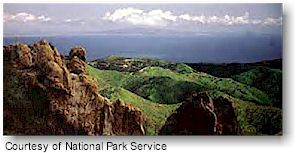 Santa Monica Mountains rise above Los Angeles, widen to meet the curve of Santa Monica Bay and reach their highest peaks facing the ocean, forming a beautiful and multi-faceted landscape. Santa Monica Mountains National Recreation Area is a cooperative effort that joins federal, state and local park agencies with private preserves and landowners to protect the natural and cultural resources of this transverse mountain range and seashore.
Comprising 153,075 acres, the Santa Monica Mountains National Recreation Area, is the World’s largest urban national park. Santa Monica Mountains rise above Los Angeles, widen to meet the curve of Santa Monica Bay and reach their highest peaks facing the ocean, forming a beautiful and multi-faceted landscape. Santa Monica Mountains National Recreation Area is a cooperative effort that joins federal, state and local park agencies with private preserves and landowners to protect the natural and cultural resources of this transverse mountain range and seashore.
Comprising 153,075 acres, the Santa Monica Mountains National Recreation Area, is the World’s largest urban national park.
Located in a Mediterranean ecosystem, the Santa Monica Mountains contain a wide variety of plants and wildlife. The mountains also have an interesting and diverse cultural history which begins with the Chumash and Gabrielino/Tongva peoples and continues today in "L.A.'s backyard."
Getting There:
The Santa Monica Mountains National Recreation Area is located west of Griffith Park in Los Angeles County and to the east of the Oxnard Plain in Ventura County. U.S. Highway 101 (Ventura Freeway) borders the mountains on the north, and State Highway 1 (Pacific Coast Highway) and the Pacific Ocean form the southern boundary. Access to most park areas is available via many roads that cross the mountains between these two major highways. A portion of the park also stretches into the Simi Hills, north of U.S. Highway 101.
The National Park Service Visitor Center is located at 401 West Hillcrest Drive in Thousand Oaks, California.
From Ventura Freeway (U. S. Highway 101) to Lynn Rd turn north on Lynn road turn east (right) on Hillcrest Drive left onto McCloud Ave. First driveway on the right.
If you are going South on the 23 Freeway, exit at the Thousand Oaks Blvd/ Hillcrest Drive exit go west or right onto Hillcrest and turn right onto McCloud.
|