 |
 |
|
|
|
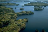
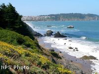
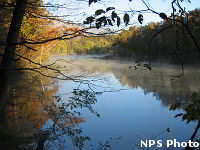
Apostle Islands National Lakeshore
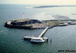
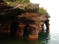 The Apostle Islands are known as the Jewels of Lake Superior. This national lakeshore is made up of 21 islands and 12 miles of mainland. Public docks are found on 13 of the islands. Camping is allowed on 18 of the islands and at one campsite on the mainland. There are more than 50 miles of trails on the islands that provide access to lighthouses, abandoned quarries, historic logging camps, beaches, campsites, old farm sites, and scenic overlooks.
There are also opportunities for scuba diving to see the underwater rock formations and the shipwrecks. There are sea caves along the mainland shore. In the summer, the sea caves are best seen by boat. You can take your own boat or kayak to explore the caves or there are outfitters who will take you on a guided tour or on a boat tour.
In the winter, if the lake is sufficiently frozen, visitors can walk, snowshoe, or ski across the ice to the cliffs. There are several guided tours offered by the park staff such as lighthouse tours, a tour of an historic commercial fishing camp or a commercial fishing museum, campfire programs, and a nature walk on Stockton Island.
For more information visit:
Apostle Islands National Lakeshore
Cumberland Island National Seashore
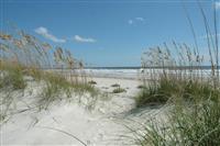 The visitor center is located in St. Marys which is in the very southeastern
tip of Georgia. Cumberland Island is 7 miles east of St. Marys and is only accessible
by boat. Cumberland Island is the largest of Georgia’s barrier islands. The
national park service has a concession that operates a passenger-only ferry
from here all year long. There is an admission fee for the park and a separate
fee for the ferry. Reservations are recommended.
The visitor center is located in St. Marys which is in the very southeastern
tip of Georgia. Cumberland Island is 7 miles east of St. Marys and is only accessible
by boat. Cumberland Island is the largest of Georgia’s barrier islands. The
national park service has a concession that operates a passenger-only ferry
from here all year long. There is an admission fee for the park and a separate
fee for the ferry. Reservations are recommended.
Beach accessible wheelchairs are available and the Park’s concession rents bikes at Sea Camp. There are more than 50 miles of hiking trails that go through forests, wetlands, historic districts, marshes and beautiful beaches. There are developed campgrounds and wilderness camping.
Other activities include fishing, stargazing, photography, boating, beach combing, kayaking, and swimming. There are over 300 species of birds as well as other wildlife like armadillos, feral horses, manatees and sea turtles to watch.
There are several guided tours or you can explore the island on your own. There is a museum on the island where you can learn about the Timucua, the Native Americans in Southeastern Georgia and Northeastern Florida, the plantation era, the gilded age, the War of 1812 and see restored carriages. You can visit the first African Baptist church and the Plum Orchard Mansion.
For more information visit:
Cumberland Island National
Seashore
Flagstaff Area National Monuments
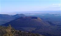 Wupatki, Sunset Crater Volcano and Walnut Canyon National Monuments protect
more than 40,000 acres and 3,000 archaeological sites near Flagstaff Arizona.
There is a one hour scenic loop road that winds through Sunset Crater Volcano
and Wupatki National Monuments.
Wupatki, Sunset Crater Volcano and Walnut Canyon National Monuments protect
more than 40,000 acres and 3,000 archaeological sites near Flagstaff Arizona.
There is a one hour scenic loop road that winds through Sunset Crater Volcano
and Wupatki National Monuments.
Wupatki is one of the warmest and driest places on the Colorado Plateau. Wupatki was home to numerous groups of people over thousands of years. Trade items from the Pacific to the Gulf of Mexico have been discovered here. There are six prehistoric pueblos here that are open to the public year round. Take a self-guided tour of the largest, Wupatki Pueblo, located behind the visitor center. All trails in the monument are under one mile.
Sunset Crater Volcano erupted more than 900 years ago changing the landscape and the lives of the people, plants and animals forever. You can hike a trail through the lava flow or enjoy a view from the Cinder Hills Overlook. Come view the night skies at one of the monthly star parties in the summer.
Walnut Canyon is having a Centennial Celebration in 2015. Come join us for a full year of guided tours and activities. Allow 2 hours to see the visitor center and museum, hike down to the cliff dwellings and walk the Rim Trail. The Island Trail goes into the canyon and provides access to 25 cliff dwelling rooms. It is one of the best ways to enjoy the park but the hike back to the top is strenuous.
For more information visit:
Flagstaff
Area National Monuments
Mount Rainier National Park
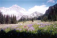 Located in western Washington about 85 miles south of Seattle. Mount Rainier
is 14,410 feet above sea level and is an active volcano.
Located in western Washington about 85 miles south of Seattle. Mount Rainier
is 14,410 feet above sea level and is an active volcano.
There are 5 developed areas in the park. All of the areas have roadside attractions and hiking trails.
Longmire is in the southwest corner of the park and has a museum, and a campground and picnic area.
Paradise is famous for meadows of wildflowers and for being one of the consistently snowiest places on Earth with an average snowfall of 641 inches. The main visitor center is here. Winter activities include snowshoeing, cross-country skiing and tubing.
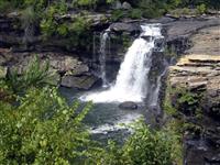
Ohanapecosh is in the southeast corner of the park and is drier and sunnier than the west side. This area is closed in the winter. There is a visitor center, a campground and picnic area and three trails to Silver Falls.
The Sunrise area is the highest point that can be reached by car in the park. This area has a visitor center, a lodge and a campground. This is the second most visited area of the park because of the breathtaking views and the variety of hiking trails.
The Carbon and Mowich area receive so much rain that the climate and plants resemble a temperate rainforest. Mowich Lake is the largest and deepest lake in the park. There are 2 campgrounds and a picnic area here. July and August are generally sunny and mild but the rest of the year is quite rainy and there is heavy snowfall from November through April. Raingear is recommended year round.
For more information visit:
Mount Rainier National Park
Joshua Tree National Park
 Located in southeastern California about an hour east of Palm Springs. This
park protects a region where the Mojave and Colorado deserts converge and is
known for its plant diversity.
Located in southeastern California about an hour east of Palm Springs. This
park protects a region where the Mojave and Colorado deserts converge and is
known for its plant diversity.
Unlike most national parks, summer is the least popular time to visit here because the temperatures exceed 100 degrees. March and April are the ideal time to visit and if there has been enough winter rain, you may see wildflowers in bloom. Even in the winter the temperatures are pleasant.
This desert only receives about 4 inches of rain a year but there are hundreds of species that live here. Red-spotted toads, round-tailed ground squirrels, bighorn sheep, coyotes, kangaroo rats and rattlesnakes are some of them.
This park has 9 campgrounds. The best way to discover this park is on foot and there are 12 short nature trails. Rock climbing is another favorite activity here with more than 400 formations to climb. It has become a world class rock climbing destination. Horseback riding, biking, stargazing and backpacking are other activities to be enjoyed here.
For more information visit:
Joshua Tree National Park
Little River Canyon National Preserve
 Located in northeastern Alabama. Little River is unique because it flows along
the top of Lookout Mountain.
Located in northeastern Alabama. Little River is unique because it flows along
the top of Lookout Mountain.
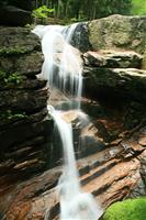
If you are entering the park from the north, the first stop you should make is Little River Falls. This 45-foot waterfall is where the Little River Canyon begins. In winter and early spring the water level is high. This is a favorite time to kayak the river. Other activities include hunting, fishing, biking, horseback riding, rock climbing and hiking.
There are several trails in the canyon including one that leads to the bottom of the canyon. Camping is only allowed at 3 campsites in the backcountry area. There is also an 11-mile scenic drive that allows you to see the beauty of the canyon from several overlooks. At one of the overlooks, you can see Grace's High falls which is a 133-foot seasonal waterfall. It isn't usually seen in the summer. Wolf Creek Overlook has one of the most beautiful views of the canyon.
There are over 140 species of birds found here including turkey vultures, woodpeckers and owls.
For more information visit:
Little River Canyon National
Preserve
Franconia Notch State Park
 Located between Franconia and Lincoln in northwestern New Hampshire. Franconia
Notch is a spectacular mountain pass where you can see waterfalls, covered bridges,
lakes and enjoy the beauty of the mountains.
Located between Franconia and Lincoln in northwestern New Hampshire. Franconia
Notch is a spectacular mountain pass where you can see waterfalls, covered bridges,
lakes and enjoy the beauty of the mountains.
Visit the Flume Gorge Visitor Center and walk through the Flume Gorge at the south end of the park. The Flume is a natural gorge that extends 800 feet. Bus service will take you to the entrance of the gorge where you can enjoy walking trails and other points of interest. You can also ride the tram at Cannon Mountain that provides scenic views at 4,200 feet or visit the New England Ski Museum.
At Echo Lake you can swim, fish or boat. This was the home of the "Old Man of the Mountain" or "Great Stone Face" immortalized by Nathaniel Hawthorne and Daniel Webster but it slid off the mountain in 2003. Profile Lake is directly below the site of the Old Man of the Mountain and is open to fly-fishing only.
Hiking on the Appalachian Trail, biking on the recreational trail, and camping are favorite activities here.
For more information visit:
Franconia Notch State Park
Capitol Reef National Park
 Located in south-central Utah. This is one of the less visited national parks
in Utah so you won't have to deal with crowds. Some of the favorite activities
here include hiking, biking, backpacking, walking through the orchards and picking
the fruit in season and visiting the petroglyph panel and historic schoolhouse.
Located in south-central Utah. This is one of the less visited national parks
in Utah so you won't have to deal with crowds. Some of the favorite activities
here include hiking, biking, backpacking, walking through the orchards and picking
the fruit in season and visiting the petroglyph panel and historic schoolhouse.
There are several auto tours through the park. The Cathedral Valley loop tour will show you panoramic views of this painted desert country, sculptured monoliths, the Gypsum Sinkhole and Glass Mountain. The Waterpocket District in the southern section of the park has a 125-mile loop tour. Side trips from this tour can provide short day hikes or serious backpacking trips to explore the more remote areas of the park.
The scenic drive takes you past rock formations, the Grand Wash, the Navajo Formation and a short trail leads to Cassidy Arch, which was named for the outlaw Butch Cassidy. In the Fruita area and the Scenic Drive, there are 15 hikes ranging from easy to strenuous. There is one developed campground and two primitive campgrounds. The geology of the area has created conditions that allowed unique plant species to grow here. There are over 880 plant species in the park.
For more information visit:
Capitol Reef National Park
Crater Lake National Park
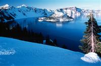 Located in southern Oregon about 85 miles northeast of Medford. Crater Lake
is over 1900 feet deep and is the deepest lake in the United States. The lake
was formed after the collapse of an ancient volcano that erupted about 7700
years ago. Because the lake is filled mostly by snowfall, it is one of the clearest
in the world.
Located in southern Oregon about 85 miles northeast of Medford. Crater Lake
is over 1900 feet deep and is the deepest lake in the United States. The lake
was formed after the collapse of an ancient volcano that erupted about 7700
years ago. Because the lake is filled mostly by snowfall, it is one of the clearest
in the world.
The park is always open but some of the roads and facilities are closed during the winter. The average snowfall is over 500 inches a year. Ranger-led snowshoe hikes are offered on weekends from late November through April. Snowshoes are provided at no cost. Cross-country skiing is available on a number of trails and snowmobiling is allowed in certain areas.
In the summer there are many activities available. Boat tours of the volcano, trolley tours, swimming, fishing, camping, hiking and ranger programs will keep you busy. The Rim Drive typically opens in June which provides more access for biking, walking and driving. There are more than 90 miles of hiking trails in the park that range from easy to strenuous or you can take a backpacking trip on the Pacific Crest Trail that stretches from Mexico to Canada.
For more information visit:
Crater Lake National Park
Voyageurs National Park
 Located near International Falls in northern Minnesota. To really enjoy this
park you need to park your car and explore by boat.
Located near International Falls in northern Minnesota. To really enjoy this
park you need to park your car and explore by boat.
There are 3 visitor centers here but only one is open year round and that is the Rainy Lake Visitor Center located on the shore of Black Bay. All 3 visitor centers have free public boat launches.
You can explore the park by guided boat tours, canoe trips or hikes. You can also charter a tour boat or camp at one of the 270 sites within the park. There are 13 Destination sites within the park boundaries that can be reached only by boat and allow visitors the opportunity to learn about the park. Many of these sites have historic structures.
There are hiking trails accessible by car and some only accessible by water. In the winter you can explore the park on one of the three packed snowshoe trails and you can even borrow snowshoes free of charge from the visitor center. Other winter activities include snowmobiling, cross-country skiing or ice-fishing.
For more information visit:
Voyageurs National Park
Congaree National Park
 Located in South Carolina about 25 minutes from downtown Columbia. Here you
will find the largest intact expanse of old growth bottomland hardwood forest
remaining in the southeastern United States.
Located in South Carolina about 25 minutes from downtown Columbia. Here you
will find the largest intact expanse of old growth bottomland hardwood forest
remaining in the southeastern United States.
The park has 22 different plant communities. Most of the park is on the Congaree River floodplain and on average the park is flooded 10 times a year. The park is best seen on the water. There are a limited number of free, ranger-guided canoe tours available each year. If you aren't lucky enough to get on one of those tours, you can bring your own kayak or canoe and explore on your own.
The Congaree River Blue Trail is a 50-mile recreational paddling trail that starts in Columbia and ends in the park. Park rangers and volunteers conduct guided programs throughout the year on topics such as a 6-mile off trail hike to some of the largest trees at Congaree, birding programs, a night hike to explore the world of owls and special programs just for kids.
There are no entrance fees at this park. Activities here include hiking, fishing, picnicking, primitive camping, bird watching and nature study. Hiking trails range from under 1 mile to just over 11 miles.
For more information visit:
Congaree National Park
Theodore Roosevelt National Park
 Located in the badlands of western North Dakota. This park is divided into 3
units: the North, South and Elkhorn Ranch unit. The park provides visitors with
the opportunity to experience many unique habitats such as wide-open prairie,
lush river bottoms, canyons and the rugged badlands.
Located in the badlands of western North Dakota. This park is divided into 3
units: the North, South and Elkhorn Ranch unit. The park provides visitors with
the opportunity to experience many unique habitats such as wide-open prairie,
lush river bottoms, canyons and the rugged badlands.
The South Unit entrance is in Medora. The visitor center has a movie, museum and information desk and is open year round. There is a paved, 36-mile scenic loop drive with pullouts and interpretive signs. Roosevelt’s first ranch home, the Maltese Cross cabin is located at this visitor center. The Painted Canyon Visitor Center, located in the South Unit, sits on the rim of one of the most spectacular overlooks in the park. It gives you panoramic views of the North Dakota Badlands.
The Elkhorn Ranch Unit is the location of Roosevelt’s second ranch in the badlands. This is where he chose to stay whenever he came to North Dakota. All that is left of the ranch are the foundations. Currently there are no plans to rebuild it. The North Unit is located near Watford City and has a 14-mile scenic drive that leads to Oxbow Overlook.
There are many hiking trails in the north and south units ranging from easy to difficult. Other activities available in the park are biking, canoeing, fishing, horseback riding, cross-country skiing and snowshoeing, and backcountry camping. All roads in the park are open to biking. The best time to take a canoe or kayak down the Little Missouri River is in May or June. Except for developed nature trails, the park trail system is open to horses. You can bring your own horse or use the park concessionaire.
For more information visit:
Theodore Roosevelt National
Park
Canaveral National Seashore
 Located midway on Florida's east coast between Daytona Beach and Melbourne.
This park is located on a barrier island and the John F Kennedy Space Center
is located at the southern end of the barrier island. Access to the seashore
is often restricted when there is a launch. The 24-mile-long beach is the longest
undeveloped beach on the east coast of the Florida. Come see what the beach
looked like 500 years ago when the Spaniards first arrived in Florida.
Located midway on Florida's east coast between Daytona Beach and Melbourne.
This park is located on a barrier island and the John F Kennedy Space Center
is located at the southern end of the barrier island. Access to the seashore
is often restricted when there is a launch. The 24-mile-long beach is the longest
undeveloped beach on the east coast of the Florida. Come see what the beach
looked like 500 years ago when the Spaniards first arrived in Florida.
Home to more than 100 plant species and 300 bird species. Some of the birds you might see are pelicans, cormorants, herons, egrets and white ibis. Some of the plants are prickly pear cactus, yucca, beach sunflower and the saw palmetto. There is a 6-mile scenic drive that takes you through the refuge and provides views of many of these. Backcountry camping is permitted in the north end of the park. There are short trails that have views of the ocean or marshes and a canoe trail. There are launch sites in the refuge and seashore for boats but airboats are prohibited. Other activities include surfing and both fresh and saltwater fishing.
Mosquito Lagoon is an estuary. An estuary is an area where fresh water meets and mixes with salt water. Sea turtles spend their adolescent years in the lagoon. Animals like the manatee and the dolphin come here to feed. Other animals find shelter in the roots of the mangrove trees. Canaveral National seashore is an important nesting area for sea turtles. You can attend a "Turtle Watch" program to learn more or visit the website to view the Turtle Nest Cam.
Summers are hot and humid. Winter temperatures are in the 60-70 degree range with short periods of cold weather.
For more information visit:
Canaveral National Seashore
White Sands National Monument
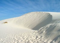 White Sands National Monument - This national monument preserves a portion of
the largest gypsum dune field in the world. The glistening White Sands are one
of the world's great natural wonders. The White Sands National Monument is located
in the south central part of New Mexico between the cities of Alamogordo and
Las Cruces. The white sands dune field is an active dune field, with the dunes
moving from west to east by as many as thirty feet per year.
White Sands National Monument - This national monument preserves a portion of
the largest gypsum dune field in the world. The glistening White Sands are one
of the world's great natural wonders. The White Sands National Monument is located
in the south central part of New Mexico between the cities of Alamogordo and
Las Cruces. The white sands dune field is an active dune field, with the dunes
moving from west to east by as many as thirty feet per year.
The visitor center includes a museum, bookstore, gift shop and restrooms. There is no water available in the dunefield. Water containers can be filled at the visitor center.
The dunes drive is an eight-mile scenic drive that begins at the visitor center and leads into the heart of the dunes. Picnic areas and pit toilets are located near the end of the the drive. The roadway is a hard surface and is suitable for passenger cars and buses. White Sands National Monument has several trails available for hiking. There are five trails in all and they vary in difficulty and what you will see.
Only backcountry camping is available at the monument. There are several public and private campgrounds within an hour's drive of the park for RVs.
Sledding down the dunes is a popular activity. Most sledders use waxed plastic snow saucers (which can be purchased at the park gift shop). Choose a dune that is away from the roadway and parking areas and is free of vegetation. The monument is also the perfect place for stargazing.
For more information visit:
White Sands National Monument
Presidio of San Francisco
 The Presidio is a former military base and part of the Golden Gate Recreation
Area. It was a fortified location from 1776 to 1994 when it was turned over
to the National Park Service. It was first owned by New Spain, then Mexico and
then the United States.
The Presidio is a former military base and part of the Golden Gate Recreation
Area. It was a fortified location from 1776 to 1994 when it was turned over
to the National Park Service. It was first owned by New Spain, then Mexico and
then the United States.
The Presidio contains over 25 miles of hiking trails. Cyclists can explore the area on 14 miles of paved roads and along some unpaved parts of the Bay Area Ridge Trail. A board sailing and kite surfing area borders Crissy Field and fishing and crabbing can be done from the nearby rocks and pier. The park also contains numerous sports facilities, including a golf course, bowling alley, tennis courts, athletic fields, as well as many historic buildings.
Fort Scott: Battery Chamberlin (Located at the north end of the Baker Beach parking lot.) - In 1977, the National Park Service received a 6-inch gun and disappearing carriage from the Smithsonian Institution. Demonstrations of this 50-ton rifle--similar to the original armament--are held on the first weekend of each month. An underground cartridge room also is open to the public and contains photos and small exhibits on the coastal defenses of San Francisco.
The Exploratorium, found in the Palace of Fine Arts, is a world-renowned museum and educational center with hundreds of exhibits on science, art, and human perception.
Fort Point - It stands beneath the Golden Gate Bridge and was completed in 1861, Fort Point is a massive brick and granite fortification constructed to defend the San Francisco Bay from naval attack.It is the only fortification of its type on the Pacific coast. Rendered obsolete with the development of rifled artillery during the Civil War, Fort Point's guns were removed by 1900. It never fired a shot in hostility. There are guided tours, exhibits and materials for self-guided tours available.
The Gulf of the Farallones National Marine Sanctuary Visitor Center features hands-on educational exhibits about local marine life.It is housed in an historic Coast Guard Station and located at the west end of Crissy Field.
For more information:
Presidio of San
Francisco
Haleakala National Park
 Located on the island of Maui. This park is divided into 2 areas - the summit
area and and coastal area. The two sections of the park are not connected by
road but both can be reached from Kahului. On the 2 hour drive to the summit,
you pass through as many ecological zones as you would traveling from Mexico
to Canada. The summit area, at 10,023 feet, is a popular place to view the sunrise
and sunset. The weather is unpredictable and the temperatures are often below
freezing before sunrise and after sunset so come prepared. The weather is often
windy and wet. There are 30 miles of hiking trails in the summit area ranging
from a few minutes to overnight trips. The Hosmer Grove Campground provides
the opportunity to camp without backpacking. It is located at about 7000 feet.
There are also 3 wilderness cabins in the area that are only accessible by hiking
in. The closest cabin is about a 4 mile hike. There are also a couple of wilderness
campsites available that are accessible only by trail. Stop at the overlooks
on the Park road and watch the sky. Rainbows, moonbows and halos around your
shadow are just some of the amazing things you might see. In the summit area,
you can see up to 115 miles out to sea.
Located on the island of Maui. This park is divided into 2 areas - the summit
area and and coastal area. The two sections of the park are not connected by
road but both can be reached from Kahului. On the 2 hour drive to the summit,
you pass through as many ecological zones as you would traveling from Mexico
to Canada. The summit area, at 10,023 feet, is a popular place to view the sunrise
and sunset. The weather is unpredictable and the temperatures are often below
freezing before sunrise and after sunset so come prepared. The weather is often
windy and wet. There are 30 miles of hiking trails in the summit area ranging
from a few minutes to overnight trips. The Hosmer Grove Campground provides
the opportunity to camp without backpacking. It is located at about 7000 feet.
There are also 3 wilderness cabins in the area that are only accessible by hiking
in. The closest cabin is about a 4 mile hike. There are also a couple of wilderness
campsites available that are accessible only by trail. Stop at the overlooks
on the Park road and watch the sky. Rainbows, moonbows and halos around your
shadow are just some of the amazing things you might see. In the summit area,
you can see up to 115 miles out to sea.
The Kipahulu area or coastal area of the park has 3 miles of trails for hiking. The temperatures are generally warm and humid. Swimming is possible in this area of the park when conditions allow. Always check at the visitor center for current conditions. Camping is available just south of the visitor center. The campground overlooks ocean cliffs.
The park is open year round. There are 3 visitor centers and all have exhibits, books and maps. There is no food, supplies or gas available in the park. Restrooms are open 24 hours a day. Haleakala National Park has more endangered species than any other park in the National Park system. There are plants and animals here that are found nowhere else on the earth. The Hawaiian Islands are the most remote major island group on earth, lying 2400 miles from the nearest continent.
For more information visit:
Haleakala National Park
Plimoth Plantation
 An America's Hometown adventure just minutes away from Cape Cod and Boston.
Fun and educational, Plimoth Plantation presents the story of the Native Wampanoag
and 17th century Pilgrim communities from their perspectives.
An America's Hometown adventure just minutes away from Cape Cod and Boston.
Fun and educational, Plimoth Plantation presents the story of the Native Wampanoag
and 17th century Pilgrim communities from their perspectives.
Enjoy this Smithsonian Institution Affiliate-living history museum of the 17th century, perfect for families and groups with our hands on environment, authenticity and engaging personal encounters. Visit role-playing interpreters aboard the Mayflower II and in the English Village or meet contemporary Native people in the Wampanoag Homesite. Experience our newest exhibit -- the Plimoth Grist Mill, where you can explore Colonial and Native history, science, technology and ecology.
Visit the Craft Center and watch as skilled artisans re-create 17th century Native and Colonial items used in our exhibits and sold in our Museum Shops. Finish your fascinating experience at the Patuxet Cafe, sampling from the menu inspired by Native and Colonial recipes.
For more information visit
Plimoth Plantation
Fall Foliage in Vermont
 Vermont has the highest percentage of maple trees in New England which makes
Vermont one of the best places to view Fall colors. Vermont is 76% forested
with more than 50 state parks. Leaves begin to change in early to mid-September
and can extend into late October. The first 2 weekends in October are generally
the busiest of the foliage season so plan ahead if you plan to visit. Different
varieties of trees change at different times and generally trees at higher elevations
turn first. Red maples are some of the first trees to change.
Vermont has the highest percentage of maple trees in New England which makes
Vermont one of the best places to view Fall colors. Vermont is 76% forested
with more than 50 state parks. Leaves begin to change in early to mid-September
and can extend into late October. The first 2 weekends in October are generally
the busiest of the foliage season so plan ahead if you plan to visit. Different
varieties of trees change at different times and generally trees at higher elevations
turn first. Red maples are some of the first trees to change.
People travel from all over the world to see the Fall colors but even in the peak season there are always rooms available. If you want to avoid the huge crowds, travel mid-week. Another way to avoid the crowds is to travel the back-roads. Village stores or local inns are great sources of information for the best places to view the Fall colors.
Besides scenic drives, Fall is also a great time to explore Vermont on a bike, in a canoe or hiking some of the beautiful trails. Enjoy a fall festival showcasing art, food, animals and more. Check out Vermont's Official Website for more detailed information.
Curecanti National Recreation Area
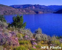 Located about 200 miles southwest of Denver, Colorado, this recreation area
is made up of 3 reservoirs along the Gunnison River. It is open all year. Elk
Creek Visitor Center is located 16 miles west of Gunnison, CO and is open daily.
There is no entrance fee.
Located about 200 miles southwest of Denver, Colorado, this recreation area
is made up of 3 reservoirs along the Gunnison River. It is open all year. Elk
Creek Visitor Center is located 16 miles west of Gunnison, CO and is open daily.
There is no entrance fee.
Things to do in Curecanti: camping, boating, fishing, fly fishing, ice fishing, hiking trails available for all abilities, horseback riding, bird watching, scenic drives and hunting. During the summer take a ride on a pontoon boat through the upper Black Canyon. Reservations are required.
Blue Mesa Reservoir has 96 miles of shoreline and is the largest body of water in Colorado. Windsurfing is popular in several areas. There are secluded canyons for boaters to explore and water skiing is also done in the late summer when the water warms up. There are no designated swimming beaches because the shoreline is steep and rocky and the water is very cold.
Morrow Point Reservoir is for the more adventurous. This one is popular for canoeing or kayaking but you have to haul your boat and gear to the water using the Pine Creek Trail.
Crystal Reservoir is also limited to boats that can be carried to the water. Because of cold water, boaters and skiers should always wear wet suits.
For more information visit
Curecanti National
Recreation Area
Saint Croix National Scenic Riverway
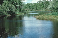 Located in both Wisconsin and Minnesota, the St. Croix River is one of the last
undisturbed, large floodplain rivers in the upper Mississippi River System.
The best way to enjoy the Riverway is paddling out on the waters and camping
on the banks.
Located in both Wisconsin and Minnesota, the St. Croix River is one of the last
undisturbed, large floodplain rivers in the upper Mississippi River System.
The best way to enjoy the Riverway is paddling out on the waters and camping
on the banks.
The upper St. Croix and all of the Namekagon River are much narrower and wilder than the rest of the National Park. They run through mostly undeveloped, diverse terrain and since you are closer to both banks, you will have more opportunities to enjoy nature and wildlife up close.
The river gets much wider in the St. Croix Marshland area. This stretch of the river is one of the best small mouth bass fisheries around. This area also has the fastest moving water so you may have some rapids.
The lower St. Croix is just an hour drive from the Twin Cities and can be a wonderful day trip. The river is much broader here which makes it great for beginners. There are many islands, back channels and sloughs to explore when the water is high. The reservoir creates deeper water which allows for motorboats. Other boats such as houseboats, pontoons, fishing boats and paddle boats are other ways to enjoy the river.
Other activities along the Riverway include fishing, hiking, tubing, bicycling, horseback riding, snowmobiling, hunting and there are ORV trails nearby.
For more information visit
Saint Croix National
Scenic Riverway
Golden Spike National Historic Site
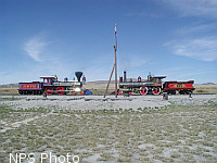 Located 32 miles west of Brigham City in northern Utah. May 10, 1869 the Union
and Central Pacific Railroads completed the first Transcontinental Railroad
at Promontory Summit in the Utah Territory. Reenactments of the "Golden Spike"
ceremony are held on Saturdays and holidays between May 1st and Columbus Day
at 11:00 a.m. and 1:30 p.m., trackside in front of the locomotives, the same
location where the original ceremony was held. Steam Demonstrations take place
every day during the summer season (May 1 - Columbus Day). These demonstrations
are when the Jupiter and No. 119 locomotives move on the tracks.
Check with the Visitor Center for exact times. The Visitor Center is open daily
from 9-5. During the winter the locomotives are stored in the engine house.
Tours are available.
Located 32 miles west of Brigham City in northern Utah. May 10, 1869 the Union
and Central Pacific Railroads completed the first Transcontinental Railroad
at Promontory Summit in the Utah Territory. Reenactments of the "Golden Spike"
ceremony are held on Saturdays and holidays between May 1st and Columbus Day
at 11:00 a.m. and 1:30 p.m., trackside in front of the locomotives, the same
location where the original ceremony was held. Steam Demonstrations take place
every day during the summer season (May 1 - Columbus Day). These demonstrations
are when the Jupiter and No. 119 locomotives move on the tracks.
Check with the Visitor Center for exact times. The Visitor Center is open daily
from 9-5. During the winter the locomotives are stored in the engine house.
Tours are available.
The Big Fill Loop Trail is a mile and a half round-trip walking trail that allows you to see and walk out on the Central Pacific's Big Fill, walk through cuts, over fills, and see drill marks where rock was blasted away. There are also 2 different auto tours that allow you to drive on the original Transcontinental Railroad grade.
There are no services in the park. The closest gas station in 26 miles away. Water and snack foods are available in the Visitor Center. Nearby attractions include the Spiral Jetty, the Bear River Migratory Bird Refuge and the Devil's Playground.
For more information visit
Golden Spike National
Historic Site
Cape Cod National Seashore
 Cape
Cod is a large peninsula that extends 60 miles into the Atlantic ocean from
the coast of Massachusetts. The Cape Cod National Seashore is 44,600 acres and
is located on the outer cape. Millions visit each year for its unspoiled
beaches, nature trails, bicycle trails, lighthouses, picnic areas, scenic overlooks
and historic sites. The park has 2 visitor centers. The Salt Pond Visitor
Center located in Eastham is the primary center and is open year round.
The Province Lands Visitor Center located in Provincetown is open May
through October. Both offer several films that rotate throughout the day.
Cape
Cod is a large peninsula that extends 60 miles into the Atlantic ocean from
the coast of Massachusetts. The Cape Cod National Seashore is 44,600 acres and
is located on the outer cape. Millions visit each year for its unspoiled
beaches, nature trails, bicycle trails, lighthouses, picnic areas, scenic overlooks
and historic sites. The park has 2 visitor centers. The Salt Pond Visitor
Center located in Eastham is the primary center and is open year round.
The Province Lands Visitor Center located in Provincetown is open May
through October. Both offer several films that rotate throughout the day.
Cape Cod National Seashore offers a wide-range of activities from walking beaches and trails year round to ranger-guided programs throughout the year. There are six swimming beaches each with their own interesting natural features. There are twelve Self-Guiding Trails at the seashore that are open year round. Interpretive folders with information on natural and historic features are available at some trailheads. Over 450 species of animals, fish and birds make the seashore their home during all or part of the year.
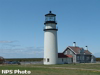
There is no greater concentration of wonderful lighthouses than those of Cape Cod and the Islands of Martha's Vineyard and Nantucket. There are 14 lighthouses along the shoreline of Cape Cod from Falmouth to Provincetown. Nine are still active but 3 of them are privately owned. Some are open for daily tours and others are only open on special days. The ones privately owned are not open for tours. The oldest lighthouse on Cape Cod is the Highland or Cape Cod Light in North Truro. President George Washington approved its construction and it began operating in 1797. The current structures date from 1857.
For more information visit
Cape Cod National
Seashore
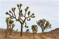
Mojave National Preserve
 This
1.6 million acre park is located between Las Vegas and Los Angeles. There
is currently no entrance fee for this park and it is open year round.
There are 3 visitor and information centers within the preserve.
Kelso Depot which served as a train station, restaurant, and employee
housing for the Union Pacific Railroad beginning in 1924, is now the primary
information center and museum. Three of the four major North American deserts
are found at Mojave National Preserve: the Mojave, Great Basin and Sonoran.
Canyons, mountains, mesas, abandoned mines and homesteads, Joshua tree forests,
volcanic cinder cones and sand dunes are waiting to be explored.
This
1.6 million acre park is located between Las Vegas and Los Angeles. There
is currently no entrance fee for this park and it is open year round.
There are 3 visitor and information centers within the preserve.
Kelso Depot which served as a train station, restaurant, and employee
housing for the Union Pacific Railroad beginning in 1924, is now the primary
information center and museum. Three of the four major North American deserts
are found at Mojave National Preserve: the Mojave, Great Basin and Sonoran.
Canyons, mountains, mesas, abandoned mines and homesteads, Joshua tree forests,
volcanic cinder cones and sand dunes are waiting to be explored.
Cinder Cones National Natural Landmark, located within Mojave National Preserve, is a complex of over 20 large cinder cones with extensive and continuous lava flows. Kelso Dunes at nearly 700 feet high are among the tallest and most extensive dune fields in the United States. The world's largest concentration of Joshua trees is also within the preserve.
Backpacking is just one of the many activities that can be enjoyed at Mojave with nearly 700,000 acres of designated wilderness. There are a few established hiking trails ranging in length from .25 miles to 16 miles and dirt roads, washes and ridges that offer many opportunities for cross-country hiking. The preserve is a camper's paradise with developed campgrounds, roadside camping, and backpacking. Horses and other pack animals are permitted on all trails, backcountry roads, and wilderness areas within the preserve. Although not an annual occurrence, a few well-timed soaking storms will produce a memorable showing of spring wildflowers. Temperatures and precipitation vary with the considerable range in elevation within the preserve ranging from about 900 feet to almost 8000 feet above sea level.
For more information visit
Mojave National Preserve
Big Cypress National Preserve
 Big
Cypress National Preserve, was the first national preserve in the National
Park System. It protects over 700,000 acres of the Big Cypress Swamp
in southern Florida. The Preserve is located on Tamiami Trail (U.S.41) approximately
half-way between Naples and Miami. There is no fee to enter the preserve but
fees are collected at some facilities within the preserve. There are two
visitor centers that are open year-round and are located on the Tamiami
Trail.
Big
Cypress National Preserve, was the first national preserve in the National
Park System. It protects over 700,000 acres of the Big Cypress Swamp
in southern Florida. The Preserve is located on Tamiami Trail (U.S.41) approximately
half-way between Naples and Miami. There is no fee to enter the preserve but
fees are collected at some facilities within the preserve. There are two
visitor centers that are open year-round and are located on the Tamiami
Trail.
Canoeing and kayaking are best from November through March when the water levels have dropped and the temperatures and the bugs are tolerable. Hiking is another activity within the preserve and it can be done on designated trails or by making your own way. Camping is also allowed and campgrounds are available on a first-come, first-served basis. There are areas that are not accessible by foot and many people enjoy exploring these remote areas by airboat.
The Tamiami Trail "Triathlon" began in January 2013. It encourages people to get out and explore the national preserve. Participants will have the opportunity to explore the mysteries of the Everglades/Big Cypress region of southwest Florida. Participants will receive a prize for the completion of the entire "triathlon."
The Preserve is a bird watcher's paradise. Almost 200 species of birds can be seen during the year. You can easily see 50 species in one visit. The Anhinga is a commonly seen bird in many areas of Big Cypress National Preserve, and other park areas in Florida but it is rarely if ever seen in other areas of the United States. Cousins to these birds are more commonly seen in South America and Africa. Egrets, Herons and White Ibis are just a few of the other birds found here.
The Preserve is also home to many mammals and reptiles unique to Florida's climate. The best time to see large congregations of Florida's largest reptile, the American Alligator, is typically from January through May. They can be viewed right at the Oasis Visitor Center in their natural environment. Alligator hatching season is typically September through October. It is also home to one of the most endangered mammals in the United States, the Florida panther.
For more information visit
Big Cypress National
Preserve
Padre Island National Seashore
 Padre
Island National Seashore is located southeast of the city of Corpus Christi,
Texas on North Padre Island and is the longest stretch of undeveloped barrier
island in the world. It separates the Gulf of Mexico from the Laguna Madre
which is one of only six lagoons in the world that is hypersaline or
saltier than the ocean. The park is open 24 hours a day, 365 days a year.
Malaquite Visitor Center is open daily (except Christmas Day), from 9:00
a.m. to 5:00 p.m., throughout the year.
Padre
Island National Seashore is located southeast of the city of Corpus Christi,
Texas on North Padre Island and is the longest stretch of undeveloped barrier
island in the world. It separates the Gulf of Mexico from the Laguna Madre
which is one of only six lagoons in the world that is hypersaline or
saltier than the ocean. The park is open 24 hours a day, 365 days a year.
Malaquite Visitor Center is open daily (except Christmas Day), from 9:00
a.m. to 5:00 p.m., throughout the year.
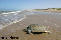
The park protects 70 miles of coastline, dunes and prairies, and is one of only a few places in the world where the Kemp’s ridley sea turtles come to nest. Kemp’s ridley sea turtles are both the smallest and the most endangered sea turtles in the world. Each year the public is invited to attend the releases of hatchlings that have been cared for at the park's incubation facility. Check the park's website for dates and times of the releases.
With 130,00 acres of undeveloped land and the close proximity to Corpus Christi, which has been named the Birdiest City in America for the past 10 years, the park is a great place to watch birds. The best time to watch birds on the island is either during the early spring or fall and winter when thousands of birds either migrate through or spend the winter.
Even before it became a national seashore, fishing has been one of the biggest attractions to Padre Island. You must have a valid Texas fishing license and a salt water stamp to fish anywhere within the park. Bicycling is another popular activity in the park but there are no riding trails and no bicycles for rent in the park. Camping is permitted at the five camping areas which are open year-round. Camping is on a first-come first-served basis.
Temperatures in the summer are usually in the 90’s with humid conditions. Winter temperatures are between 50-70 degrees but can drop into the 30’s. It is humid all year.
For more information visit
Padre Island National
Seashore
Cape Lookout National Seashore
 Cape Lookout National Seashore is located off the North Carolina coast and consists
of 56 miles of undeveloped beach. Unlike neighboring beaches, no bridges
connect the islands to the mainland. A boat ride is a must for reaching the
area. You can use your own boat or take a ferry. Ferry service to the park
is generally offered from mid-March to the first weekend in December. There
are no paved roads, concession stands, showers, stores or trash cans. The seashore
is open 24 hours and 365 days a year. Harkers Island Visitor Center
is open daily except Christmas and New Years from 9-5. The other 2 visitor centers
are open from April to November.
Cape Lookout National Seashore is located off the North Carolina coast and consists
of 56 miles of undeveloped beach. Unlike neighboring beaches, no bridges
connect the islands to the mainland. A boat ride is a must for reaching the
area. You can use your own boat or take a ferry. Ferry service to the park
is generally offered from mid-March to the first weekend in December. There
are no paved roads, concession stands, showers, stores or trash cans. The seashore
is open 24 hours and 365 days a year. Harkers Island Visitor Center
is open daily except Christmas and New Years from 9-5. The other 2 visitor centers
are open from April to November.
There are many activities to enjoy at the seashore. Spring and fall at the seashore offer some of the best fishing on the Atlantic Coast. There are no fishing piers in the park. There are charter boat services located in several towns along the North Carolina coast. Swimming is done at your own risk as there are no lifeguards on the beaches. Primitive camping as well as hiking, birdwatching, shelling and kayaking are also possible activities. Since the islands are only two and three miles from the mainland, even beginning kayakers can enjoy the marshes and shallow waters of the sounds and more experienced kayakers can continue out into the surf.
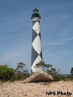
If you are visiting during the summer, you can tour the Keeper's Quarters Museum, visit the Light Station Visitor Center and maybe climb the lighthouse. You can only climb the lighthouse on certain days from the second week in May through the third weekend in September. You can purchase your tickets at the Light Station Visitor Center. It has 207 steps and the climb to the top is strenuous. It was built in 1859 but has only been open to the public for regular climbs since 2010.
Shackleford Banks is the southern-most barrier island and is home to more than 110 wild horses. This is one of the few places in the eastern United States where wild horses can still be seen. Shackleford Banks is approximately nine miles long and averages less than a mile wide.
For more information visit
Cape Lookout National
Seashore
Rocky Mountain National Park
 Within the 416 square miles of wilderness there are 60 mountains over 12,000
feet high, clear lakes, forests, waterfalls, and a variety of wildlife to observe.
Scenic drives are just one of the many activities that can be enjoyed.
Plan at least a half day for a trip on the Trail Ridge Road. Eleven of
the 48 miles of this drive are above treeline where the elevation is near 11,500
feet. This drive offers magnificent views from the comfort of a car.
Within the 416 square miles of wilderness there are 60 mountains over 12,000
feet high, clear lakes, forests, waterfalls, and a variety of wildlife to observe.
Scenic drives are just one of the many activities that can be enjoyed.
Plan at least a half day for a trip on the Trail Ridge Road. Eleven of
the 48 miles of this drive are above treeline where the elevation is near 11,500
feet. This drive offers magnificent views from the comfort of a car.
If you want to be more active, there are 355 miles of hiking trails within the park. They range from flat strolls along a lake to climbing steep mountains. Elevations range from 7,500 feet to over 12,000 feet so it is good to check with the rangers at one of the 7 visitor centers to help in choosing an appropriate hike. Some are open year round and some are closed in the winter. Use the park's free shuttle bus service to access many of the hikes. Winter brings deep snow to the west side of the park but the east side receives less snow so the lower elevation trails are open for hiking even without the aid of skis or snow shoes. There are no ski lifts in the park but cross country skis can be used to navigate even on the west side of the park.
Fishing is permitted in the park but some bodies of water only allow catch and release. There are 5 campgrounds within the park but no hookups at any of them. There are 60 miles of hard-surfaced road for biking but no off road biking is permitted. Wildlife watching is one of the top activities for visitors at the park. With an elk herd over 3000 and about 800 bighorn sheep, as well as mule deer and moose there are ample opportunities to view the animals in their natural habitat. Approximately 260 miles of trails are open to horses, mules, llamas, and burros.
On September 4, 2014, Rocky Mountain National Park will begin a year of festivities celebrating the 100th Anniversary of its creation.
For more information visit
Rocky Mountain National
Park
Ozark National Scenic Riverways
 Ozark National Scenic Riverways is the first national park area to protect a
river system. Two famous rivers, the Current and Jacks Fork Rivers, are
part of the national park as well as hundreds of freshwater springs, caves,
trails and historic sites. The rivers are much less crowded during the off
season and on weekdays in the summer. There are several places to rent canoes
in the area. They will put you in, provide all the equipment and pick you up
at the end of the day. Some offer kayaks, rafts and tubes,
too.
Ozark National Scenic Riverways is the first national park area to protect a
river system. Two famous rivers, the Current and Jacks Fork Rivers, are
part of the national park as well as hundreds of freshwater springs, caves,
trails and historic sites. The rivers are much less crowded during the off
season and on weekdays in the summer. There are several places to rent canoes
in the area. They will put you in, provide all the equipment and pick you up
at the end of the day. Some offer kayaks, rafts and tubes,
too.
There are many things to do in addition to floating the rivers. Bicycling, hiking, horseback riding, bird watching, camping, stargazing, exploring caves, hunting and fishing are just a few. There are many species of birds and animals along the waterways. Late fall migration brings the bald eagles to winter along the rivers. Hawks, herons, owls, whip-poor-wills, and wood ducks are just some of the other birds you might see. Turtles, lizards, snakes, otters, beaver, mink and muskrats are found in the water and along the waterways. Prickly pear cactus and paw paw trees grow near the forests of hardwood trees.
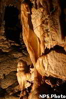
Over 300 caves have been identified within this national park. The largest has almost 7 miles of passages. Eight caves have been designated as outstanding natural features. Currently only 2 caves in the park are open to the public because of the risk of a disease that is killing millions of bats across the United States.
Visit the historic Alley Mill that was built in 1894. Much of the original milling equipment is still in place. It is open daily during the summer and is available any time by request for informal tours. There is also an old country store and a one room school house.
Several visitor centers are open within the park with various hours and seasons. Watercress Headquarters in Van Buren, Missouri is open year round. Akers Visitor Center has a life sized cave exhibit and other centers allow you to borrow a fishing pole or binoculars.
Camping is free from October 15 - April 15. There are developed campsites, back country campsites and primitive campsites. All campgrounds are open year round but facilities are reduced in the winter.
For more information visit
Ozark National Scenic
Riverways
Petrified Forest National Park
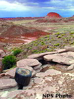 Petrified
Forest National Park is located in northeastern Arizona, about 50 miles from
the New Mexico border on Interstate 40. The best way to enjoy and experience
Petrified Forest National Park is on foot. Designated trails range in length
from less than a half-mile to three miles. Bicycles are not allowed
on trails or off roads at any time. There is no public transportation to or
within the park. There is no lodging in the park or overnight camping. Activities
include photography, hiking, geocaching, horseback riding, backpacking and wildlife
watching.
Petrified
Forest National Park is located in northeastern Arizona, about 50 miles from
the New Mexico border on Interstate 40. The best way to enjoy and experience
Petrified Forest National Park is on foot. Designated trails range in length
from less than a half-mile to three miles. Bicycles are not allowed
on trails or off roads at any time. There is no public transportation to or
within the park. There is no lodging in the park or overnight camping. Activities
include photography, hiking, geocaching, horseback riding, backpacking and wildlife
watching.
Despite its seemingly barren appearance, the ecosystem at the park is not desert. It's one of the largest areas of intact grassland in the Southwest. Hundreds of species of plants and animals can be found in the park, including toads, salamanders, lizards, coyote, fox, bobcat, mule deer, squirrels and birds ranging for eagles to hummingbirds. Early morning is the best time to view mammals while in the park. There are over 800 archeological and historic sites within the park. Paleontologists find new fossils, including new species of plants and animals, each year.
The Painted Desert Visitor Center provides information, exhibits, a restaurant, an orientation film and gift shop. Petrified wood is almost solid quartz, weighing 168 pounds per cubic foot. It is so hard, you can only cut it with a diamond tipped saw. Thousands of years ago it was so abundant that the people in the area used it to build houses.
For more information visit
Petrified Forest
National Park
Sleeping Bear Dunes National Lakeshore
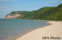 No
matter what the season, there is plenty to do at the Sleeping Bear Dunes National
Lakeshore. There are over 100 miles of hiking trails and many of them
are accessible in winter by skis or snowshoes. The 35 miles of mainland Lake
Michigan beaches offer great swimming and sunbathing in the summer and
incredible views for a quiet hike at any time of the year. Another way to
enjoy the area is to float the Platte River on a tube, raft, canoe, or kayak.
No
matter what the season, there is plenty to do at the Sleeping Bear Dunes National
Lakeshore. There are over 100 miles of hiking trails and many of them
are accessible in winter by skis or snowshoes. The 35 miles of mainland Lake
Michigan beaches offer great swimming and sunbathing in the summer and
incredible views for a quiet hike at any time of the year. Another way to
enjoy the area is to float the Platte River on a tube, raft, canoe, or kayak.
If you have only a few hours to spend at Sleeping Bear Dunes National Lakeshore, start at the Phillip A. Hart Visitor Center in Empire, MI to get oriented, get your maps and see the slide show. Everybody likes to climb the dunes. The Dune Climb offers plenty of sand for your climbing pleasure. You can picnic at the bottom or climb to the top for a view of Glen Lake. If you have 3-4 hours, you can hike through the dunes all the way to Lake Michigan.
Visit the U.S. Coast Guard Museum to learn about the history of the U.S. Life-Saving Service, U.S. Coast Guard, and Great Lakes shipping. Walk through the boathouse next to the museum and see the life-saving equipment used during the early 1900’s. Walk through Glen Haven, a lumbering village restored to the way it was around 1900. You can visit a Blacksmith Shop, walk through the Cannery Boathouse to see the displays of some of the boats used on the Great Lakes, visit the General Store that offers typical merchandise and items related to the history of the area and then take a swim or walk along the beach.If you have a few days in the area, take a day trip to South Manitou Island. Take a tour of the lighthouse which provides a great view of the island and the mainland, walk through the village and imagine what it would have been like to live here 100 years ago or hike the trails to see some of the historic farmsteads and the old schoolhouse.
There are numerous other activities besides climbing, hiking and floating the river. Some of these include bicycling, fishing, snowmobiling, swimming, camping, hunting and scuba diving.
For more information visit
Sleeping Bear Dunes
National Lakeshore
Glacier Bay National Park and Preserve
 Glacier
Bay offers limitless opportunities for adventure and inspiration. The national
park and preserve are almost 3.3 million acres which is roughly the size
of the state of Connecticut. It is part of one of the largest internationally
protected Biosphere Reserves in the world, and it is recognized by the United
Nations as a World Heritage Site. The diverse land and seascape includes
tidewater glaciers, mountain ranges, ocean coastlines, deep fjords, and freshwater
rivers and lakes. Currently glaciers cover 1,375 square miles or 27% of
the Park. There are over 50 named glaciers, 7 of which are active tidewater
glaciers that calve icebergs into the sea.
Glacier
Bay offers limitless opportunities for adventure and inspiration. The national
park and preserve are almost 3.3 million acres which is roughly the size
of the state of Connecticut. It is part of one of the largest internationally
protected Biosphere Reserves in the world, and it is recognized by the United
Nations as a World Heritage Site. The diverse land and seascape includes
tidewater glaciers, mountain ranges, ocean coastlines, deep fjords, and freshwater
rivers and lakes. Currently glaciers cover 1,375 square miles or 27% of
the Park. There are over 50 named glaciers, 7 of which are active tidewater
glaciers that calve icebergs into the sea.
Glacier Bay National Park is largely water and most visitors experience it from a boat. Most visitors arrive on cruise ships and tour boats. The only road is 10 miles from the tiny town of Gustavus. Camping, hiking, backpacking, kayaking, rafting, and mountaineering are just some of the activities that will provide great rewards at this national park.
Glacier Bay is a photographer's paradise with its abundant wildlife and many moods. With 240 species of birds in the park, bird watching is a popular activity. The Kittlitz’s Murrelet is a small, potato-sized seabird found only in Alaska and parts of Russia. It is one of North America's least known bird species. Humpback whales spend the summer in Glacier Bay and swim to Hawaii for the winter.
Summer visitors can expect highs between 50 - 60 F. The area receives 70-75 inches of precipitation annually. April, May, and June are usually the driest months. September and October are usually the wettest. Winter temperatures rarely drop into the single digits. Up in the mountains, conditions are more severe with colder temperatures and more snowfall. With over 100 feet of snow year-round, it is one of the World's snowiest places.
For more information visit
Glacier Bay National
Park and Preserve
Boston National Historical Park
 Many
of the sites of the Boston National Historical Park are located along the
2.5 mile Freedom Trail. There are 16 official sites along the trail including
the Boston Common, The State House, King's Chapel and the Old North Church.
The trail is best experienced on foot. Maps and information can be found
at the new, state-of-the-art, visitor center in historic Faneuil Hall
or at the Navy Yard Visitor Center. Some of the privately owned and operated
sites have admission fees and do not accept the National Parks Pass for admission.
There is no fee at the federally owned sites, including the Bunker Hill Monument,
Bunker Hill Museum, and the U.S.S. CONSTITUTION. Ranger-led programs
on the Freedom Trail and at Faneuil Hall are also free.
Many
of the sites of the Boston National Historical Park are located along the
2.5 mile Freedom Trail. There are 16 official sites along the trail including
the Boston Common, The State House, King's Chapel and the Old North Church.
The trail is best experienced on foot. Maps and information can be found
at the new, state-of-the-art, visitor center in historic Faneuil Hall
or at the Navy Yard Visitor Center. Some of the privately owned and operated
sites have admission fees and do not accept the National Parks Pass for admission.
There is no fee at the federally owned sites, including the Bunker Hill Monument,
Bunker Hill Museum, and the U.S.S. CONSTITUTION. Ranger-led programs
on the Freedom Trail and at Faneuil Hall are also free.
 There
are a variety of ways to enjoy the park including tours, lectures, costumed
programs, exhibits and publications. National park Service Ranger lead 90-minute
walking tours of the downtown portion of the Freedom Trail daily from mid-April
through November. If you want to customize your tour, you can use the
new
official app for the Boston National Historical Park to explore the area
and create your own, special experience of Historic Boston. The free app is
available for both the Android and iPhone or iPad. The app will provide you
with information on important historic sites in Boston as well as visiting hours
and information on each of these sites. In depth walking directions and estimated
travel times are also provided. You can choose thematic tours, ranger picks,
or build your own tour.
There
are a variety of ways to enjoy the park including tours, lectures, costumed
programs, exhibits and publications. National park Service Ranger lead 90-minute
walking tours of the downtown portion of the Freedom Trail daily from mid-April
through November. If you want to customize your tour, you can use the
new
official app for the Boston National Historical Park to explore the area
and create your own, special experience of Historic Boston. The free app is
available for both the Android and iPhone or iPad. The app will provide you
with information on important historic sites in Boston as well as visiting hours
and information on each of these sites. In depth walking directions and estimated
travel times are also provided. You can choose thematic tours, ranger picks,
or build your own tour.
For more information visit
Boston National Historical
Park
The National Park Service Sesquicentennial Commemoration of the Civil War
 There
are over 70 parks in the National Park System which have resources that
are related to the history of the Civil War. They provide opportunities to tour
the real places where this struggle occurred nearly 150 years ago. From
Fort Sumter National Monument in South Carolina where the Civil War began
on April 12, 1861 to Appomattox Court House National Historic Park in
Virginia where Lee surrendered on April 9, 1865 and everywhere in between. There
are forts, visitor centers, cemeteries, museums, quiet battlefields to explore
and living history demonstrations. Take the opportunity to visit some historic
places that shaped our nation.
There
are over 70 parks in the National Park System which have resources that
are related to the history of the Civil War. They provide opportunities to tour
the real places where this struggle occurred nearly 150 years ago. From
Fort Sumter National Monument in South Carolina where the Civil War began
on April 12, 1861 to Appomattox Court House National Historic Park in
Virginia where Lee surrendered on April 9, 1865 and everywhere in between. There
are forts, visitor centers, cemeteries, museums, quiet battlefields to explore
and living history demonstrations. Take the opportunity to visit some historic
places that shaped our nation.
Few people who visit the Outer Banks realize that these islands were battlefields during the Civil War. Whoever could control these barrier islands and sounds could control North Carolina. Although not as famous as other great Civil War battles, they were pivotal for control of North Carolina. One island even became a symbol of hope for slaves seeking a new life.
 The
state of Virginia was the site of 122 battles during the Civil War. 3
times more than in any other state. Visit the
Fredericksburg &
Spotsylvania National Military Park in Virginia to learn more about the
human cost of this war. If you are interested in information about the battles,
visit The American
Battlefield Protection Program to get locations, dates, commanders, estimated
casualties, descriptions of the battles and the results.
The
state of Virginia was the site of 122 battles during the Civil War. 3
times more than in any other state. Visit the
Fredericksburg &
Spotsylvania National Military Park in Virginia to learn more about the
human cost of this war. If you are interested in information about the battles,
visit The American
Battlefield Protection Program to get locations, dates, commanders, estimated
casualties, descriptions of the battles and the results.
Visit Abraham Lincoln Birthplace National Historical Park in Kentucky or Ford's Theatre National Historic Site in Washington, DC to learn more about the president that served during the Civil War and struggled to unite a nation.
For more information visit
The National
Park Service Sesquicentennial Commemoration of the Civil War
Mammoth Cave National Park
 Mammoth
Cave, located in Kentucky, is the world's longest known cave, with
more than 390 miles of connected passages. Even if the second and third
longest caves in the world were joined together, Mammoth would still be more
than 100 miles longer. It is one of the oldest tourist attractions in the
country. Your exploration of the cave will take you to places unlike anything
you have ever seen. Most of the park's facilities are available free of charge.
Fees are charged for cave tours and camping. There are more than a
dozen cave tours ranging in difficulty from easy to strenuous. Cave tours
range from 1/4 mile to over 5 miles. There are specialized tours to meet everyone's
interests. There is a photo tour and a tour just for children ages 8-12. On
this tour, hard hats, knee pads, coveralls and headlamps are provided so they
can hike, crawl and belly slide through rarely visited passages. There are also
tours for older children and adults that offer some of the same experiences
but on a more strenuous scale. Some of the tours show the history of early mining
in the caves, the history and role of the cave during the War of 1812, an underground
hospital and an underground river.
Mammoth
Cave, located in Kentucky, is the world's longest known cave, with
more than 390 miles of connected passages. Even if the second and third
longest caves in the world were joined together, Mammoth would still be more
than 100 miles longer. It is one of the oldest tourist attractions in the
country. Your exploration of the cave will take you to places unlike anything
you have ever seen. Most of the park's facilities are available free of charge.
Fees are charged for cave tours and camping. There are more than a
dozen cave tours ranging in difficulty from easy to strenuous. Cave tours
range from 1/4 mile to over 5 miles. There are specialized tours to meet everyone's
interests. There is a photo tour and a tour just for children ages 8-12. On
this tour, hard hats, knee pads, coveralls and headlamps are provided so they
can hike, crawl and belly slide through rarely visited passages. There are also
tours for older children and adults that offer some of the same experiences
but on a more strenuous scale. Some of the tours show the history of early mining
in the caves, the history and role of the cave during the War of 1812, an underground
hospital and an underground river.
Above the cave, there are several ways to enjoy the park. Over 30 miles of the Green and Nolin Rivers flow through the park and offer many recreational opportunities. Fishing is good throughout the year with almost 100 species of fish including bass, bluegill and catfish. There is no designated swimming areas in the park because of the swift water and no lifeguards on duty. There are 2 ferries that cross the 200 foot wide Green River or enjoy taking a canoe down the river. There are 3 developed campgrounds and more than a dozen primitive sites along the rivers. There are many hiking trails available ranging from less than 1/4 mile to 8 miles. In addition to hiking trails, there are 60 miles of trails open for horseback riding.
For more information visit
Mammoth Cave National Park
Hawai'i Volcanoes National Park
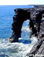 Since
the new eruption at the Pu’u ‘O’o vent on August 3, 2011, there is even more
to see at Hawai’i Volcanoes National Park. Lava from this vent has reached
the ocean within the park boundaries for the first time since 2009. This national
park covers over 300,000 acres of diverse and changing environments.
You will find alpine landscapes, rain forest, desert, active volcanoes and rugged
coastline. The park highlights two of the world's most active volcanoes,
Kilauea and Mauna Loa, and gives insights into the birth of the Hawaiian
Islands.
Since
the new eruption at the Pu’u ‘O’o vent on August 3, 2011, there is even more
to see at Hawai’i Volcanoes National Park. Lava from this vent has reached
the ocean within the park boundaries for the first time since 2009. This national
park covers over 300,000 acres of diverse and changing environments.
You will find alpine landscapes, rain forest, desert, active volcanoes and rugged
coastline. The park highlights two of the world's most active volcanoes,
Kilauea and Mauna Loa, and gives insights into the birth of the Hawaiian
Islands.
The park is open 24 hours a day, year round. The Kilauea Visitor Center is open from 7:45 a.m. 5:00 p.m. Because of the dynamic nature of the two active volcanoes in the park, conditions can change rapidly. Lava flow is always changing. Check at the Kilauea Visitor Center for the most current information. The fee to enter the park is $10 and is good for 7 days. The Kilauea Visitor Center should be your first stop. It features exhibits, a movie and a bookstore. The Jaggar Museum is a museum on volcanology. The overlook offers spectacular views into the summit caldera.
The park can be explored by car in just a few hours or you can spend several days exploring it. If you have only one to three hours, explore the summit of Kilauea volcano via Crater Rim Drive; an 11-mile road that encircles the summit caldera, passes through desert, lush tropical rain forest, traverses the caldera floor, and provides access to well-marked scenic stops and short walks. With over 150 miles of trails in the park, there are many opportunities to explore the park on foot. There are day hikes as well as wilderness hikes. Obtain trail information, maps and permits at the Visitor’s Center. The park has 2 drive-in campgrounds that allow you to camp free of charge. There are no safe beaches or swimming areas within the park.
Weather on the island is unpredictable. Visitors should be prepared for rain and dress in layers. Weather at Kilauea’s summit may be 10-15 degrees cooler than at sea level. December through March typically receive the most rainfall but it may rain any time of the year. Visitors should wear sturdy close-toed shoes and long pants if planning to walk or hike on the lava because falling on lava is like falling on broken glass.
For more information visit
Hawai'i Volcanoes National
Park
Gulf Islands National Seashore
 Gulf
Islands National Seashore is a park rich in natural resources. There are
sparkling blue waters, magnificent white beaches, coastal marshes, and winding
nature trails. It is America’s largest national seashore and is located
in Mississippi and Florida. The two districts are about a two-hour drive apart.
Although Gulf Islands National Seashore is 80% underwater, the islands
and mainland sites attract millions of visitors each year. In Florida all areas
are accessible by car, and in Mississippi, only the Davis Bayou Area is accessible
by car. The passenger ferry to West Ship Island, MS operates spring through
fall and leaves from the Gulfport Yacht Harbor. All areas of the Florida District
are open year-round unless posted. Operating hours vary seasonally and from
unit to unit. The park operates four visitor centers in both states.
Gulf
Islands National Seashore is a park rich in natural resources. There are
sparkling blue waters, magnificent white beaches, coastal marshes, and winding
nature trails. It is America’s largest national seashore and is located
in Mississippi and Florida. The two districts are about a two-hour drive apart.
Although Gulf Islands National Seashore is 80% underwater, the islands
and mainland sites attract millions of visitors each year. In Florida all areas
are accessible by car, and in Mississippi, only the Davis Bayou Area is accessible
by car. The passenger ferry to West Ship Island, MS operates spring through
fall and leaves from the Gulfport Yacht Harbor. All areas of the Florida District
are open year-round unless posted. Operating hours vary seasonally and from
unit to unit. The park operates four visitor centers in both states.
Whether you visit for a day or a week, there are many activities to choose from and many places to explore. Activities include bicycling, snorkeling, fishing, beach combing, and wildlife watching. Both districts offer developed campgrounds as well as primitive camping. There are miles of shoreline and opportunities to swim but it is best to swim at beaches with lifeguards or designated swim beaches. The Santa Rosa Sound shoreline is popular for people with small children who want to avoid the rough surf at the beach. The Okaloosa Day Use Area is a quiet water area that features white sandy beaches, calm waters, picnic tables, a boat launch, parking, and public restrooms with outdoor showers. There are also a variety of ranger-led tours to visit historic forts, hike through dune and salt marsh habitats or walk along the barrier islands. The forts of Gulf Islands National Seashore span almost 150 years, from the Spanish colonial time period in the late 1700’s to the World War Two-era. All of the forts saw action during the Civil War and will be part of the National Park service commemoration of the 150th anniversary of the Civil War.
For more information visit
Gulf Islands National Seashore
Channel Islands National Park
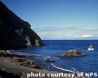 Close
to the California mainland, yet worlds apart, Channel Islands National Park
encompasses five remarkable islands and their surrounding one mile of
ocean. Each of the islands is a fascinating world unto itself. Isolation over
thousands of years has created unique animals, plants, and archeological
resources found nowhere else on Earth. The Channel Islands are often called
the "North American Galapagos" because they are home to over 150 endemic
or unique species. There are wonderful places to hike, camp, snorkel,
kayak, birdwatch, take photographs, sketch, or just relax to the soothing
sounds of the natural world.
Close
to the California mainland, yet worlds apart, Channel Islands National Park
encompasses five remarkable islands and their surrounding one mile of
ocean. Each of the islands is a fascinating world unto itself. Isolation over
thousands of years has created unique animals, plants, and archeological
resources found nowhere else on Earth. The Channel Islands are often called
the "North American Galapagos" because they are home to over 150 endemic
or unique species. There are wonderful places to hike, camp, snorkel,
kayak, birdwatch, take photographs, sketch, or just relax to the soothing
sounds of the natural world.
The mainland visitor centers in Ventura and Santa Barbara are readily accessible by car or public transportation, but the islands are only accessible by park concessionaire boats and planes or private boat. Transportation to the islands is available year-round. There is no transportation available on the islands. All areas must be accessed on foot or by private boat or kayak.
In general, the islands have a Mediterranean climate year-round. Temperatures average highs in the mid-60s (°F) and lows in the low-50s. Visitors to the islands must be prepared for high winds, fog, rough seas, and sea spray at any time. Visitors should be aware that ocean and weather conditions vary considerably from day-to-day and island-to-island.
For more information visit
Channel
Islands National Park
Dinosaur National Monument
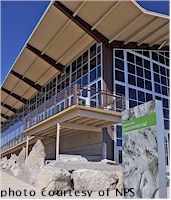 Most
visitors come to Dinosaur National Monument to see dinosaur fossils.
After being closed for over 5 years, the world-famous Carnegie Dinosaur Quarry
re-opened on October 4, 2011. Excavations were started here in 1909 and
numerous fossil specimens found here are displayed in museums around the world.
When the excavations ended, over 1500 fossils were left in place on the
cliff face so visitors can view them as they were found. Fossils at Dinosaur
National Monument represent only 10 of the many dinosaur species that existed.
Most
visitors come to Dinosaur National Monument to see dinosaur fossils.
After being closed for over 5 years, the world-famous Carnegie Dinosaur Quarry
re-opened on October 4, 2011. Excavations were started here in 1909 and
numerous fossil specimens found here are displayed in museums around the world.
When the excavations ended, over 1500 fossils were left in place on the
cliff face so visitors can view them as they were found. Fossils at Dinosaur
National Monument represent only 10 of the many dinosaur species that existed.
First stop is the visitors center where you will find a twelve minute film, exhibits, and a bookstore. During the summer, you can only access the Quarry by shuttle bus. Weather can be a factor in your visit. Highs range from 30 degrees in the winter with some roads closed because of snow to 100 degrees in July. Check with the visitors center for road conditions. About 1000 years ago, the Fremont people lived in this area and left evidence of their lives in the form of petroglyphs and pictographs. Several areas in the monument allow visitors easy access to these designs and allow up-close viewing.
Besides viewing dinosaur fossils, hiking and river rafting are two of the most popular activities here. Biking, fishing, camping, horseback riding and scenic drives are also available activities.
For more information visit
Dinosaur
National Monument
Mount Rushmore National Memorial
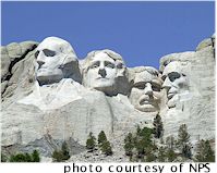 What started as an idea to bring tourists to South Dakota turned into a monument
that conveyed the meaning of America. A state historian originally wanted
the sculpture to be a parade of Indian leaders and American explorers who shaped
the frontier. Gutzon Borglum was asked to take on the project but he
wanted the sculpture to be a monument that conveyed the meaning of America.
He chose 4 U.S. Presidents: Washington represents the birth of the
country, Jefferson represents the expansion of the country,
Lincoln symbolizes the preservation of the country and Roosevelt
represents the development of the country.
What started as an idea to bring tourists to South Dakota turned into a monument
that conveyed the meaning of America. A state historian originally wanted
the sculpture to be a parade of Indian leaders and American explorers who shaped
the frontier. Gutzon Borglum was asked to take on the project but he
wanted the sculpture to be a monument that conveyed the meaning of America.
He chose 4 U.S. Presidents: Washington represents the birth of the
country, Jefferson represents the expansion of the country,
Lincoln symbolizes the preservation of the country and Roosevelt
represents the development of the country.
Work on the monument was begun in the Fall of 1927. 90% of the heads were carved by dynamite. Washington’s head was completed in less than 3 years. The head of Thomas Jefferson was originally started on the right side of Washington but after 18 months of work, it had to be blasted off the mountain and started on his left side. Each of the heads were completed and dedicated at different times. The monument took 14 years to complete. Once a year the park service staff repels over the side of the faces to inspect and caulk any cracks.
There is no entrance fee to Mount Rushmore but there is a parking fee. The park is open year round except for December 25. The weather in the area is highly variable and changes quickly so it is best to check weather conditions before going. There is no overnight camping in the park.
For more information visit
Mount Rushmore National Memorial
Mesa Verde National Park
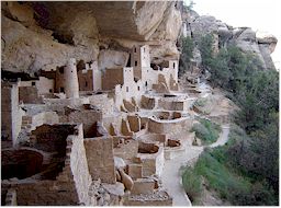 Mesa Verde, located in southwestern Colorado, remains one of the most spectacular
parks anywhere in the world. It was the first national park designed to preserve
the works of man. It preserves more than 4,000 archeological sites which
include 600 cliff dwellings. It offers a look into the lives of the ancestral
Pueblo people who lived in the area from 600 A.D. to 1300 A.D.
Mesa Verde, located in southwestern Colorado, remains one of the most spectacular
parks anywhere in the world. It was the first national park designed to preserve
the works of man. It preserves more than 4,000 archeological sites which
include 600 cliff dwellings. It offers a look into the lives of the ancestral
Pueblo people who lived in the area from 600 A.D. to 1300 A.D.
The park is open year round, but some of the tours and access to sites are seasonal. Ranger guided tours are offered seasonally, and allow you to hike into some of the sites. Cliff Palace is the largest cliff dwelling at Mesa Verde National Park. It has 150 rooms and an additional 75 open areas. This is one of the ranger guided tours and is available from April to November. Ninety percent of the cliff dwellings at Mesa Verde contain 10 rooms or less. Tours can be strenuous so you should be in good physical condition.
There are also several self-guided tours including the Spruce Tree House which is the best preserved cliff dwelling and has over 100 rooms. This self-guided tour is only a half mile round trip walk. There is also a 6-mile driving tour that has 12 easily accessible sites. There is also a museum, a visitors center, lodge, restaurant, cafeteria and gift shop.
For more information visit
Mesa Verde National Park
Yellowstone National Park
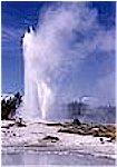 Yellowstone
is located in parts of Wyoming, Montana and Idaho and is America's first
national park. A large variety of wildlife lives in the park including grizzly
bears, wolves, bison, and elk. Yellowstone is open every day of the year.
Summer activities include bicycling, boating, camping, backcountry hiking,
day hikes, fishing, and horseback riding. Winter activities include cross
country skiing, and snowmobile and snowcoach tours.
Yellowstone
is located in parts of Wyoming, Montana and Idaho and is America's first
national park. A large variety of wildlife lives in the park including grizzly
bears, wolves, bison, and elk. Yellowstone is open every day of the year.
Summer activities include bicycling, boating, camping, backcountry hiking,
day hikes, fishing, and horseback riding. Winter activities include cross
country skiing, and snowmobile and snowcoach tours.
With half of the earth's geogthermal features, Yellowstone holds the planet's most diverse and intact collection of geysers, hot springs, mudpots, and fumaroles. There are more geysers here than anywhere else on earth, with Old Faithful being the most famous. Steamboat, the largest geyser in the world, reaches heights of 300-400 feet.
Most of the park is above 7,500 feet so unpredictability more than anything else characterizes the weather. Bring a warm jacket and rain gear even in the summer. Summer temperatures are often in the 70's and may drop to below freezing at night in the higher elevations.
For more information visit
Yellowstone National Park
Olympic National Park
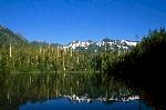 Olympic
National Park has ocean beaches, rain forest valleys, and snow covered mountains.
The park is open all year but some roads and park facilities are closed in the
winter.
Olympic
National Park has ocean beaches, rain forest valleys, and snow covered mountains.
The park is open all year but some roads and park facilities are closed in the
winter.
With over 900,000 acres, there are endless possibilities for recreation and relaxation. Backpacking, camping, fishing, walking along sandy beaches or an easy stroll through the rain forest are just some of the activities to choose from.
Olympic has a wide range of climate conditions. About twelve feet of rain falls each year on the west-facing valleys and only about 2 feet of rain falls on the east side of the mountains. Come prepared for a wide range of conditions regardless of when you visit. Rain gear is essential. July, August and September are the driest months.
For more information visit
Olympic National Park
Glacier National Park
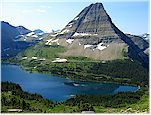 Glacier
National Park is celebrating its 100th anniversary in 2010. One of the most
amazing highlights of visiting this park is the drive on the Going-to-the-Sun
Road. Although the park is open all year, generally all visitor facilities are
open from late May to early September. The average visitor spends 3 to 4 days
in the park. Some scientists predict that the glaciers may be gone by 2020.
Glacier
National Park is celebrating its 100th anniversary in 2010. One of the most
amazing highlights of visiting this park is the drive on the Going-to-the-Sun
Road. Although the park is open all year, generally all visitor facilities are
open from late May to early September. The average visitor spends 3 to 4 days
in the park. Some scientists predict that the glaciers may be gone by 2020.
There are over 700 miles of trails that lead to some of the most spectacular scenery around. Besides hiking and biking other activities include boating, camping, fishing, horseback rides and cross country skiing in the winter. It is an outdoor paradise. It is home to over 70 species of mammals and over 200 species of birds. The weather is diverse and can change rapidly. It can be as hot as 90 degrees in the afternoon and drop to freezing at night. Dress in layers and always be prepared for rain.
click
here for more information
Big Bend National Park
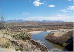 Big
Bend National Park includes more than 800,000 acres in southwest Texas. It is
located in one of the most sparsely populated areas of the country. It includes
mountain, desert, and river environments. An hour’s drive can take you from
the banks of the Rio Grande to a mountain basin nearly a mile high. Here, you
can explore one of the last remaining wild corners of the United States. The
wide range in altitude from 1800 feet to over 7000 feet contributes to diversity
in plant and animal life.
Big
Bend National Park includes more than 800,000 acres in southwest Texas. It is
located in one of the most sparsely populated areas of the country. It includes
mountain, desert, and river environments. An hour’s drive can take you from
the banks of the Rio Grande to a mountain basin nearly a mile high. Here, you
can explore one of the last remaining wild corners of the United States. The
wide range in altitude from 1800 feet to over 7000 feet contributes to diversity
in plant and animal life.
Winters are normally mild but below freezing temperatures can occur. The
diversity of Big Bend offers something for just about everyone. To really experience
the park, you should get out on foot and enjoy some of the more than 200 miles
of trails.
click
here for more information
Everglades National Park
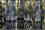 This
national park is the 3rd largest in the lower 48 states, covering 2500 square
miles. It is the largest subtropical wilderness in the United States and proclaimed
as one of the great biologic wonders of the world. Over 50 distinct kinds of
reptiles can be found in the park. Over 360 species of birds have been recorded
in the park. It boasts a lush growth of plant life, over 1,000 species of plants,
from both the temperate North American climate and the tropical Caribbean climate.
This
national park is the 3rd largest in the lower 48 states, covering 2500 square
miles. It is the largest subtropical wilderness in the United States and proclaimed
as one of the great biologic wonders of the world. Over 50 distinct kinds of
reptiles can be found in the park. Over 360 species of birds have been recorded
in the park. It boasts a lush growth of plant life, over 1,000 species of plants,
from both the temperate North American climate and the tropical Caribbean climate.
Winter is the busy season and most facilities are open. It is mild and pleasant
from December through April with temperatures averaging in the upper 70's. The
diverse habitats allow for hiking, canoe and kayaking, biking, fresh and saltwater
fishing, and camping.
click
here for more information
Acadia National Park
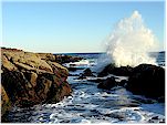 Acadia
National Park was the first National Park east of the Mississippi River. The
tallest mountain on the U.S. Atlantic coast is located here. The park is open
all year but many of the facilities are closed in the winter.
Acadia
National Park was the first National Park east of the Mississippi River. The
tallest mountain on the U.S. Atlantic coast is located here. The park is open
all year but many of the facilities are closed in the winter.
You can enjoy this park on bike, foot or horse-drawn carriage tour. It has 125 miles of historic hiking trails through forests and up mountains. You could also take a ranger-narrated boat cruise to learn about sea life.
The summer temperatures average in the 70's so it is important to dress in layers. The Maine coast is ranked second in the U.S. for annual precipitation and fog is common in the summer.
For more information visit
Acadia National Park